
Soubor:Abandoning the Arctic Exploration Ship Jeanette, by James Gale Tyler.jpg
Původní soubor (852 × 581 pixelů, velikost souboru: 148 KB, MIME typ: image/jpeg)
| Tento soubor pochází z Wikimedia Commons. Níže jsou zobrazeny informace, které obsahuje jeho tamější stránka s popisem souboru. |
Popis
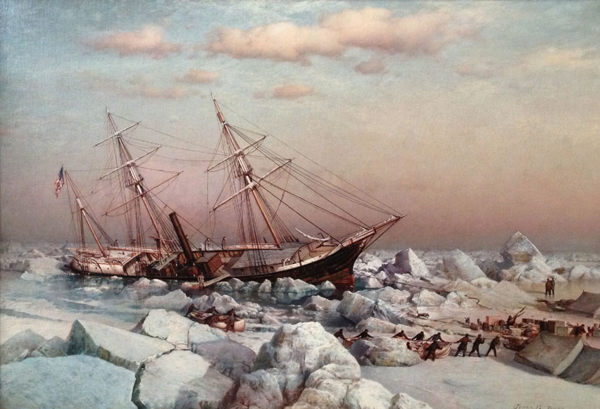
| James Gale Tyler: Abandoning the Arctic Exploration Ship Jeanette on June 12th 1891
|
||||||||||||||||||
|---|---|---|---|---|---|---|---|---|---|---|---|---|---|---|---|---|---|---|
| Tvůrce |
|
 | ||||||||||||||||
| Název |
Abandoning the Arctic Exploration Ship Jeanette on June 12th 1891 |
|||||||||||||||||
| Druh objektu | malba | |||||||||||||||||
| Popis |
English: Abandoning the Arctic Exploration Ship Jeanette on June 12th 1891, by James Gale Tyler. A time-line of the expedition illustrates the enormity of the challenge the men faced. Publisher James Gordon Bennett, Jr. purchased the ship, previously the HMS Pandora, and allied with the U.S. Government to fund the expedition. The Jeanette left San Francisco on July 8, 1879 and was held fast in ice east of Wrangell Island by September. The ship drifted northwest in the ice for the rest of 1879, all of 1880 and landed at an island they named Henrietta Island, in honor of Bennett, on May 9, 1881. This was more than 600 miles from where they first became stuck. While trapped, the men led by Lieut. Commander George W. DeLong, Assistant Surgeon James Ambler, Lieut. Charles Chipp and Chief Engineer George W. Melville battled hunger and fierce atmospheric conditions, all while conducting their scientific assignments, hunting, and maintaining their ship. |
|||||||||||||||||
| Datum | 1883 | |||||||||||||||||
| Historie | India House, New York | |||||||||||||||||
| Zdroj/Fotograf | Vallejo Gallery | |||||||||||||||||
| Pozice fotografa | | Tento snímek a mnohé další na: OpenStreetMap |
|---|
Licence
|
Toto je věrná fotografická reprodukce původního dvourozměrného uměleckého díla. Ono dílo je samo volným dílem, a to z následujícího důvodu:
Oficiálním stanoviskem nadace Wikimedia Foundation je, že „věrné reprodukce dvourozměrných volných děl jsou také volné a opačná tvrzení jsou útokem na samotný koncept volných děl.“ Podrobnosti naleznete na stránce Commons:When to use the PD-Art tag.
Tato fotografická reprodukce se tedy také považuje za volné dílo. Uvědomte si, že v závislosti na místních zákonech může být další užití tohoto díla ve vaší jurisdikci zakázáno či omezeno. Vizte Commons:Reuse of PD-Art photographs. | ||||
Historie souboru
Kliknutím na datum a čas se zobrazí tehdejší verze souboru.
| Datum a čas | Náhled | Rozměry | Uživatel | Komentář | |
|---|---|---|---|---|---|
| současná | 21. 5. 2019, 20:26 | | 852 × 581 (148 KB) | Broichmore | Cropped 1 % horizontally, 3 % vertically using CropTool with precise mode. |
| 21. 5. 2019, 20:24 |  | 864 × 599 (133 KB) | Broichmore | User created page with UploadWizard |
Využití souboru
Tento soubor používá následující stránka:
Globální využití souboru
Tento soubor využívají následující wiki:
- Využití na ca.wikipedia.org
- Využití na en.wikipedia.org
- Využití na es.wikipedia.org
- Využití na ja.wikipedia.org
- Využití na lv.wikipedia.org
- Využití na ru.wikipedia.org
- Využití na www.wikidata.org