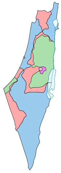
Soubor:1947-UN-Partition-Plan-1949-Armistice-Comparison.svg

Velikost tohoto PNG náhledu tohoto SVG souboru: 213 × 597 pixelů. Jiná rozlišení: 85 × 240 pixelů | 171 × 480 pixelů | 274 × 768 pixelů | 365 × 1 024 pixelů | 730 × 2 048 pixelů | 367 × 1 029 pixelů.
Původní soubor (soubor SVG, nominální rozměr: 367 × 1 029 pixelů, velikost souboru: 48 KB)
Historie souboru
Kliknutím na datum a čas se zobrazí tehdejší verze souboru.
| Datum a čas | Náhled | Rozměry | Uživatel | Komentář | |
|---|---|---|---|---|---|
| současná | 8. 11. 2013, 21:38 | 367 × 1 029 (48 KB) | Ori~ | Reverted to version as of 16:16, 7 May 2013 | |
| 8. 11. 2013, 21:36 | 367 × 1 029 (61 KB) | Ori~ | ED | ||
| 7. 5. 2013, 18:16 | 367 × 1 029 (48 KB) | Wickey-nl | Extended vertical border in Dead Sea, as half of the Dead Sea was included in the partition map, the right half assigned to Transjordan. The horizontal border is part of the 1949 armistice demarcation lines. | ||
| 6. 5. 2013, 16:53 | 367 × 1 029 (37 KB) | Wickey-nl | Not sure if upload was correct. | ||
| 6. 5. 2013, 16:45 | 367 × 1 029 (36 KB) | Wickey-nl | Added line Dead Sea. Source: http://unispal.un.org/UNISPAL.NSF/0/f03d55e48f77ab698525643b00608d34/$FILE/Arm_1949.jpg | ||
| 15. 7. 2007, 13:32 | 367 × 1 029 (21 KB) | AnonMoos | exact SVG conversion of original vector PostScript source | ||
| 13. 7. 2007, 21:35 | 367 × 1 029 (16 KB) | Retama | == Sumario == {{Information |Description=Vectorizado de Image:1947-UN-Partition-Plan-1949-Armistice-Comparison.png |Source=Own work, User:Electionworld file-based. |Date=13 jul 2007 |Author=Retama 19:03, 13 July 2007 (UTC) |Permis |
Využití souboru
Tento soubor nepoužívá žádná stránka.
Globální využití souboru
Tento soubor využívají následující wiki:
- Využití na ar.wikipedia.org
- Využití na arz.wikipedia.org
- Využití na azb.wikipedia.org
- Využití na bg.wikipedia.org
- Využití na ca.wikipedia.org
- Využití na cy.wikipedia.org
- Využití na de.wikipedia.org
- Využití na en.wikipedia.org
- Palestinians
- West Bank
- 1948 Arab–Israeli War
- History of the State of Palestine
- Palestinian territories
- United Nations Partition Plan for Palestine
- 1949 Armistice Agreements
- Lausanne Conference of 1949
- History of the Arab–Israeli conflict
- Arab–Israeli conflict
- Talk:Triangle (Israel)
- Jordan Valley
- Palestine 194
- Template:Partition Plan-Armistice Lines comparison map legend
- Palestinian Declaration of Independence
- Talk:State of Palestine/Archive 11
- Nakba
- User:Skingames2012/sandbox
- User:Falcaorib/Israel and Palestine
- Využití na eo.wikipedia.org
- Využití na es.wikipedia.org
- Využití na et.wikipedia.org
- Využití na eu.wikipedia.org
- Využití na fa.wikipedia.org
- Využití na fr.wikipedia.org
- Využití na ha.wikipedia.org
- Využití na he.wikipedia.org
- Využití na hy.wikipedia.org
Zobrazit další globální využití tohoto souboru.


