Soubor:1806 Cary Map of Tartary or Central Asia - Geographicus - Tartary-cary-1806.jpg

Obsah stránky není podporován v jiných jazycích.
Z Wikipedie, otevřené encyklopedie

Původní soubor(5 000 × 4 569 pixelů, velikost souboru: 8,57 MB, MIME typ: image/jpeg)

John Cary: A New Map of Mongolian & Independent Tartary , From the Latest Authorities.   (Wikidata search (Cirrus search) Wikidata query (SPARQL)  Create new Wikidata item based on this file)
Tvůrce
John Cary  (–1835)  wikidata:Q3446124 s:en:Author:John Cary
 
Pseudonym
J. Cary
Popis kartograf, rytec, mapseller, prodejce tisků a grafik
Datum narození / úmrtí 23. února 1755 / 1754 Edit this at Wikidata 16. srpna 1835 Edit this at Wikidata
Místo narození / úmrtí Corsley Mortlake
Období tvorby 1788 / 1793 / 1797 Edit this at Wikidata
Místo tvorby
Soubor autorit
artist QS:P170,Q3446124
Název
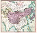
A New Map of Mongolian & Independent Tartary , From the Latest Authorities.
Popis
English: An exceptionally beautiful example of John Cary’s important 1806 map of Mongolian and Independent Tartary. Covers Central Asia from the Caspian Sea to Japan, extends as far north as the Obskaia Sea and as far south as India, Burma and the Philippines. Includes the modern day nations of Uzbekistan, Kazakhstan, Turkmenistan, Kirgizstan, Tajikistan and Mongolia. One of Cary’s most interesting maps. Central Asia, despite hundreds of years of passing trade on the Silk Routes, was still, at the turn of the century a largely unknown land. Cary attempts to show some of the Silk Route passages, especially to the north of the Gobi, but ultimately admits, “The Geography of these parts is extremely obscure.” All in all, one of the most interesting and few maps of Central Asia to appear in first years of the 19th century. Prepared in 1806 by John Cary for issue in his magnificent 1808 New Universal Atlas. (NOTE: The reproduction of the colors in this map appear to be incorrect, as Japan and Tibet were never part of Chinese Tartary yet appear to be the same color as it.)
Datum 1806 (dated)
Rozměry výška: 18,5 in (46,9 cm); šířka: 20 in (50,8 cm)
dimensions QS:P2048,18.5U218593
dimensions QS:P2049,20U218593
Inventární číslo
Geographicus link: Tartary-cary-1806
Zdroj/Fotograf

Cary, John, Cary's New Universal Atlas, containing distinct maps of all the principal states and kingdoms throughout the World. From the latest and best authorities extant. London: Printed for J. Cary, Engraver and Map-seller, No. 181, near Norfolk Street, Strand, 1808.

Svolení
(Užití tohoto souboru)
Toto je věrná fotografická reprodukce původního dvourozměrného uměleckého díla. Ono dílo je samo volným dílem, a to z následujícího důvodu:
Public domain

Toto dílo je volné také v zemích, jejichž právní řád chrání majetková autorská práva po dobu života autora a 100 let po jeho smrti.


You must also include a United States public domain tag to indicate why this work is in the public domain in the United States.
Oficiálním stanoviskem nadace Wikimedia Foundation je, že „věrné reprodukce dvourozměrných volných děl jsou také volné a opačná tvrzení jsou útokem na samotný koncept volných děl.“ Podrobnosti naleznete na stránce Commons:When to use the PD-Art tag.
Tato fotografická reprodukce se tedy také považuje za volné dílo. Uvědomte si, že v závislosti na místních zákonech může být další užití tohoto díla ve vaší jurisdikci zakázáno či omezeno. Vizte Commons:Reuse of PD-Art photographs.
Další verze
Poznámky
InfoField
K tomuto souboru existují poznámky: Prohlédnout si poznámky na Commons

Popisky

Přidejte jednořádkové vysvětlení, co tento soubor představuje

Položky vyobrazené v tomto souboru

zobrazuje

3d7f1be3ae7a9539d26d91394bee37e7dc951779

8 990 511 bajt

4 569 pixel

5 000 pixel

Historie souboru

Kliknutím na datum a čas se zobrazí tehdejší verze souboru.

Datum a časNáhledRozměryUživatelKomentář
současná19. 8. 2019, 10:56Náhled verze z 19. 8. 2019, 10:565 000 × 4 569 (8,57 MB)SoerfmBrightness, color
22. 3. 2011, 12:56Náhled verze z 22. 3. 2011, 12:565 000 × 4 569 (7,81 MB)BotMultichillT{{subst:User:Multichill/Geographicus |link=http://www.geographicus.com/P/AntiqueMap/Tartary-cary-1806 |product_name=1806 Cary Map of Tartary or Central Asia |map_title=A New Map of Chinese & Independent Tartary , From the Latest Authorities. |description=

Tento soubor používá následující stránka:

Globální využití souboru

Tento soubor využívají následující wiki:

Metadata