
Soubor:PIA22217 – Rock Stripes Pattern in Mars' 'Perseverance Valley'.jpg

Původní soubor (3 741 × 1 361 pixelů, velikost souboru: 588 KB, MIME typ: image/jpeg)
| Tento soubor pochází z Wikimedia Commons. Níže jsou zobrazeny informace, které obsahuje jeho tamější stránka s popisem souboru. |
Popis
| Popis |
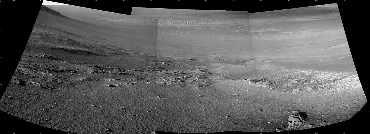
English: Textured rows on the ground in this portion of "Perseverance Valley" are under investigation by NASA's Mars Exploration Rover Opportunity, which used its Navigation Camera (Navcam) to take the component images of this downhill-looking scene.
The rover took this image on Jan. 4, 2018, during the 4,958th Martian day, or sol, of its work on Mars, looking downhill from a position about one-third of the way down the valley. Perseverance Valley descends the inboard slope of the western rim of Endeavour Crater. A view on the same sol with the rover's front Hazard Avoidance Camera includes ground even closer to the rover at this site. Opportunity was still working close by as it reached the mission's Sol 5,000 (Feb. 16, 2018). In the portion of the valley seen here, soil and gravel have been shaped into a striped pattern in the foreground and partially bury outcrops visible in the midfield. The long dimensions of the stripes are approximately aligned with the downhill direction. The striped pattern resembles a type of feature on Earth (such as on Hawaii's Mauna Kea) that is caused by repeated cycles of freezing and thawing, though other possible origins are also under consideration for the pattern in Perseverance Valley. The view is spans from north on the left to east-southeast on the right. For scale, the foreground rock clump in the lower right is about 11 inches (28 centimeters) in width. NASA's Jet Propulsion Laboratory, a division of the California Institute of Technology in Pasadena, manages the Mars Exploration Rover Project for NASA's Science Mission Directorate, Washington. For more information about Opportunity, visit http://www.nasa.gov/rovers and http://marsrovers.jpl.nasa.gov. |
| Datum | 4 January 2018 (published 15 January 2018) |
| Zdroj | Catalog page · Full-res (JPEG · TIFF) |
| Autor | NASA/JPL-Caltech |
| Poloha na Marsu | Tento snímek a mnohé další na: Mapy Google |
|---|
Tento mediální soubor byl katalogizován v Jet Propulsion Laboratory amerického Národního úřadu pro letectví a kosmonautiku (NASA)pod Photo ID: PIA22217. Toto oznámení nepopisuje autorskoprávní status tohoto souboru. Stále je vyžadován běžný popisek licence. Další informace najdete na Commons:Licencování. Jiné jazyky:
|
| This media is a product of the Mars Exploration Rover mission Credit and attribution belongs to the mission team, if not already specified in the "author" row |
Licence
| This file is in the public domain in the United States because it was solely created by NASA. NASA copyright policy states that "NASA material is not protected by copyright unless noted". (See Template:PD-USGov, NASA copyright policy page or JPL Image Use Policy.) | ||
 |
Warnings:
|
Historie souboru
Kliknutím na datum a čas se zobrazí tehdejší verze souboru.
| Datum a čas | Náhled | Rozměry | Uživatel | Komentář | |
|---|---|---|---|---|---|
| současná | 16. 2. 2018, 06:57 | 3 741 × 1 361 (588 KB) | PhilipTerryGraham | User created page with UploadWizard |
Využití souboru
Tento soubor používá následující stránka: