
Soubor:Location of the BOTs.svg

Velikost tohoto PNG náhledu tohoto SVG souboru: 735 × 433 pixelů. Jiná rozlišení: 320 × 189 pixelů | 640 × 377 pixelů | 1 024 × 603 pixelů | 1 280 × 754 pixelů | 2 560 × 1 508 pixelů.
Původní soubor (soubor SVG, nominální rozměr: 735 × 433 pixelů, velikost souboru: 1,26 MB)
| Tento soubor pochází z Wikimedia Commons. Níže jsou zobrazeny informace, které obsahuje jeho tamější stránka s popisem souboru. |
Popis
| Popis |
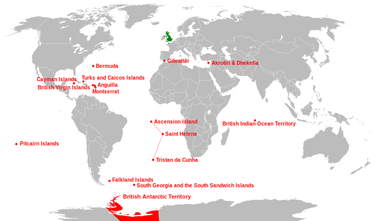
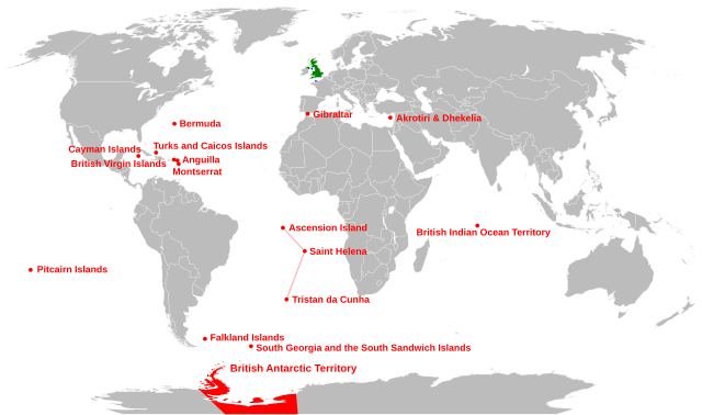
English: Location of the British Overseas Territories (red), Crown dependencies (blue), and Great Britain and Northern Ireland (green) |
| Datum | |
| Zdroj |
Tento soubor byl odvozen z: |
| Autor | Richardprins |
| Další verze |
Díla odvozená od tohoto souboru: |
| SVG vývoj | Tento vektorový obrázek byl vytvořen programem Inkscape, or with something else. |


Licence
| Já, autor tohoto díla, jej tímto uvolňuji jako volné dílo, a to celosvětově. V některých zemích to není podle zákona možné; v takovém případě: Poskytuji komukoli právo užívat toto dílo za libovolným účelem, a to bezpodmínečně s výjimkou podmínek vyžadovaných zákonem. |
Historie souboru
Kliknutím na datum a čas se zobrazí tehdejší verze souboru.
| Datum a čas | Náhled | Rozměry | Uživatel | Komentář | |
|---|---|---|---|---|---|
| současná | 29. 4. 2024, 05:30 | | 735 × 433 (1,26 MB) | Illchy | File uploaded using svgtranslate tool (https://svgtranslate.toolforge.org/). Added translation for id. |
| 29. 4. 2015, 09:01 |  | 735 × 433 (1,28 MB) | Carnby | South Sudan border | |
| 25. 1. 2011, 00:23 |  | 735 × 433 (1,26 MB) | Malus Catulus | fixed country borders | |
| 23. 1. 2011, 17:37 |  | 735 × 433 (1,28 MB) | Malus Catulus | typo fix and pitcairn location fix | |
| 23. 1. 2011, 17:15 |  | 735 × 433 (1,28 MB) | Malus Catulus | Changed font size of Antartic... | |
| 23. 1. 2011, 17:03 |  | 735 × 433 (1,28 MB) | Malus Catulus | Faulty text be fixed, yarrr | |
| 23. 1. 2011, 14:48 |  | 735 × 433 (1,26 MB) | Malus Catulus | Minor corrections | |
| 22. 1. 2011, 18:20 |  | 735 × 433 (1,26 MB) | Malus Catulus | few adjustments, corrected Atlantic Ocean Islands | |
| 1. 10. 2010, 08:30 |  | 735 × 433 (1,21 MB) | Pfly | Attempt to improve graphics of previous edit fix | |
| 1. 10. 2010, 08:23 |  | 735 × 433 (1,21 MB) | Pfly | Moved British Indian Ocean Territory to correct location. |
Využití souboru
Tento soubor používají následující 2 stránky:
Globální využití souboru
Tento soubor využívají následující wiki:
- Využití na af.wikipedia.org
- Využití na an.wikipedia.org
- Využití na ast.wikipedia.org
- Využití na azb.wikipedia.org
- Využití na az.wikipedia.org
- Využití na br.wikipedia.org
- Využití na ca.wikipedia.org
- Využití na da.wikipedia.org
- Využití na de.wikipedia.org
- Využití na el.wikipedia.org
- Využití na en.wikipedia.org
- Využití na es.wikipedia.org
- Využití na eu.wikipedia.org
- Erresuma Batua
- Ingalaterra
- Eskozia
- Gibraltar
- Ipar Irlanda
- Gales
- Ascension
- Santa Helena
- Falklandak
- Man
- Jersey
- Guernesey
- Hegoaldeko Georgiak
- Pitcairn uharteak
- Hegoaldeko Sandwichak
- Hegoaldeko Georgiak eta Hegoaldeko Sandwichak
- Birjina britainiar uharteak
- Bermuda
- Kaiman uharteak
- Montserrat (uhartea)
- Turkak eta Caicoak
- Aingira (dependentzia)
- Txantiloi:Erresuma Batuko lurralde antolaketa
- Akrotiri eta Dhekelia
- Britainiar koroaren dependentzia
- Erresuma Batuaren banaketa administratiboa
- Itsasoaz haraindiko britainiar lurralde
Zobrazit další globální využití tohoto souboru.