
Soubor:Extent of territorial control in sri lanka.png
Velikost tohoto náhledu: 375 × 599 pixelů. Jiná rozlišení: 150 × 240 pixelů | 601 × 960 pixelů.
Původní soubor (601 × 960 pixelů, velikost souboru: 243 KB, MIME typ: image/png)
| Tento soubor pochází z Wikimedia Commons. Níže jsou zobrazeny informace, které obsahuje jeho tamější stránka s popisem souboru. |
Popis

|
Tento obrázek (skupina military map) by měl být vytvořen pomocí vektorové grafiky jako SVG soubor. To má několik výhod; podrobnosti najdete na stránce Commons:Media for cleanup. Je-li SVG verze tohoto obrázku již k dispozici, prosím nahrajte ji. Po nahrání nahraďte tuto šablonu šablonou {{Vector version available|jméno nového obrázku.svg}}.
|
Licence

|
Tento dokument smí být kopírován, šířen nebo upravován podle podmínek Svobodné licence GNU pro dokumenty verze 1.2 nebo libovolné vyšší verze publikované nadací Free Software Foundation. Dokument nemá neměnné části ani texty na předním či zadním přebalu. Kopie textu licence je k dispozici v oddíle nazvaném GNU Free Documentation License. |
| Tento soubor podléhá licenci Creative Commons Uveďte autora-Zachovejte licenci 3.0 Unported | ||
| ||
| Tato licenční šablona byla k tomuto souboru přidána v rámci změny licencování. |
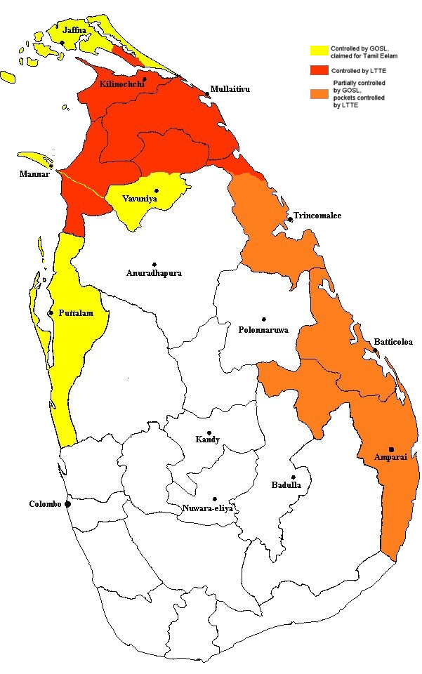
According to the creator, the source was a humanitarian aid decision by the EU (reference no. ECHO/-SA/BUD/2005/02000, available online at http://ec.europa.eu/echo/pdf_files/decisions/2005/dec_sa_02000.pdf).
Historie souboru
Kliknutím na datum a čas se zobrazí tehdejší verze souboru.
| Datum a čas | Náhled | Rozměry | Uživatel | Komentář | |
|---|---|---|---|---|---|
| současná | 29. 12. 2005, 00:19 | | 601 × 960 (243 KB) | Vadakkan | This map approximately shows the areas of Sri Lanka controlled by the LTTE and the Government, as of December 2005. The information as to areas of control was taken from a report issued by the European Union. The map was originally uploaded to :en by [[:e |
Využití souboru
Tento soubor používají následující 2 stránky:
Globální využití souboru
Tento soubor využívají následující wiki:
- Využití na ar.wikipedia.org
- Využití na ast.wikipedia.org
- Využití na az.wikipedia.org
- Využití na bg.wikipedia.org
- Využití na br.wikipedia.org
- Využití na ca.wikipedia.org
- Využití na da.wikipedia.org
- Využití na de.wikinews.org
- Využití na en.wikipedia.org
- Využití na eo.wikipedia.org
- Využití na fi.wikipedia.org
- Využití na fr.wikipedia.org
- Využití na hr.wikipedia.org
- Využití na hu.wikipedia.org
- Využití na is.wikipedia.org
- Využití na it.wikipedia.org
- Využití na ja.wikipedia.org
- Využití na ja.wikinews.org
- Využití na ko.wikipedia.org
- Využití na kw.wikipedia.org
- Využití na la.wikipedia.org
- Využití na nl.wikipedia.org
- Využití na no.wikipedia.org
- Využití na pl.wikipedia.org
- Využití na ps.wikipedia.org
- Využití na pt.wikipedia.org
- Využití na scn.wikipedia.org
- Využití na sh.wikipedia.org
- Využití na sv.wikipedia.org
- Využití na ta.wikipedia.org
- Využití na tr.wikipedia.org
- Využití na www.wikidata.org
- Využití na zh.wikipedia.org