
Soubor:Three Mile Island (color).jpg
Velikost tohoto náhledu: 625 × 600 pixelů. Jiná rozlišení: 250 × 240 pixelů | 500 × 480 pixelů | 800 × 768 pixelů | 1 067 × 1 024 pixelů | 2 134 × 2 048 pixelů | 2 592 × 2 488 pixelů.
Původní soubor (2 592 × 2 488 pixelů, velikost souboru: 2,62 MB, MIME typ: image/jpeg)
| Tento soubor pochází z Wikimedia Commons. Níže jsou zobrazeny informace, které obsahuje jeho tamější stránka s popisem souboru. |
Popis
| Popis |
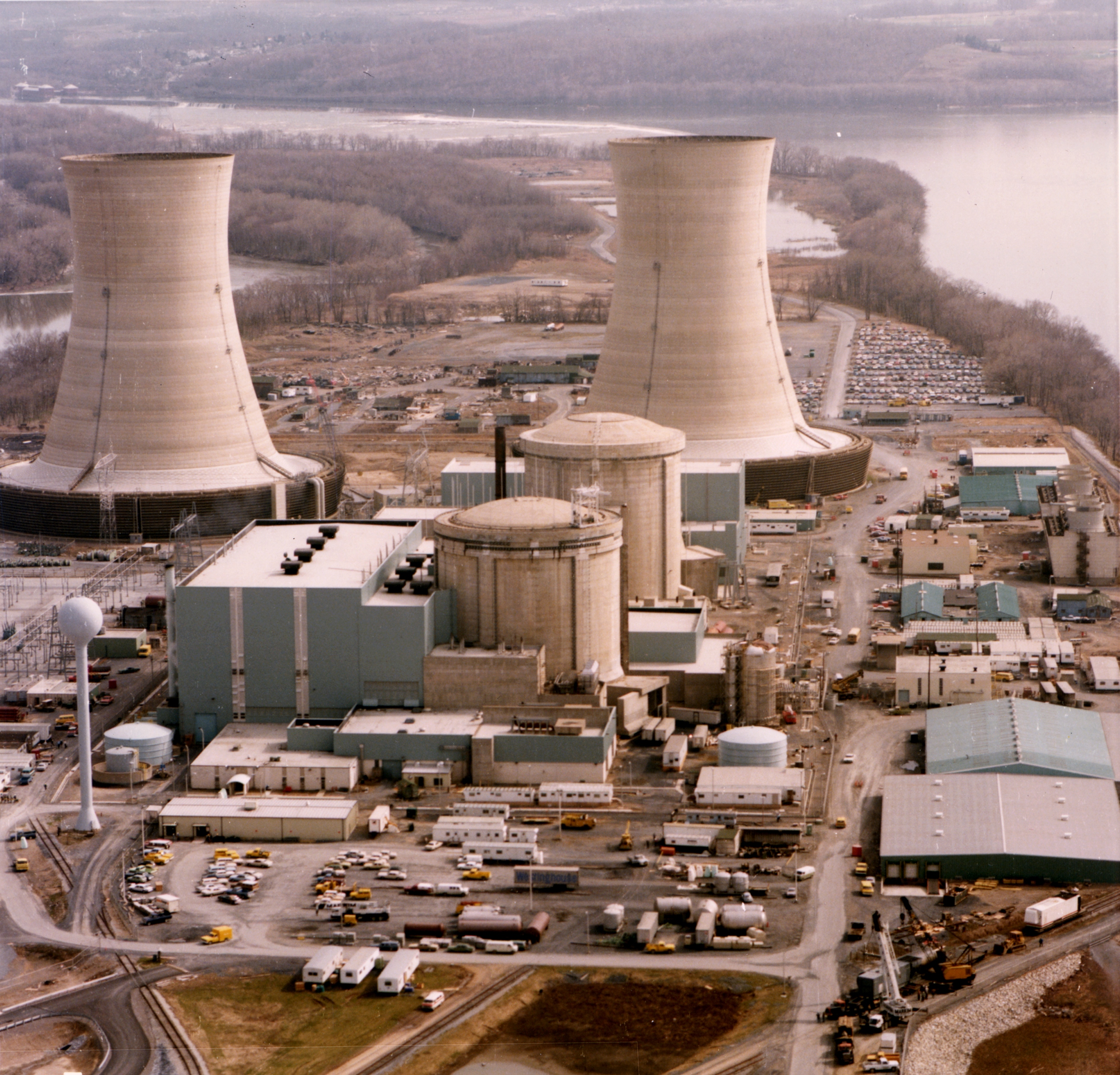
English: Color photograph of the Three Mile Island nuclear generating station, which suffered a partial meltdown in 1979. The reactors are in the smaller domes with rounded tops (the large smokestacks are just cooling towers).
Français : Photographie en couleurs de la centrale nucléaire de Three Mile Island, aux états-Unis, qui a subi une fusion partielle d'un de ses réacteurs, en 1979. Les réacteurs sont dans les dômes en béton. Les grandes cheminées ne sont que de tours de refroidissement. |
| Datum | |
| Zdroj | http://ma.mbe.doe.gov/me70/history/photos.htm |
| Autor | United States Department of Energy |
| Svolení (Užití tohoto souboru) |
Identified on DOE page as "DOE photo", i.e. not copyrighted. |
| Další verze |
|
-2.jpg)
.jpg)
| Pozice fotografa | | Tento snímek a mnohé další na: OpenStreetMap |
|---|
.jpg¶ms=040.156606_N_-076.725812_E_globe:Earth_type:camera_region:US_heading:180.00&language=cs)

|
Tento obrázek byl posouzen podle kritérií pro hodnotné obrázky a je považován za nejhodnotnější obrázek na Commons v rámci pole působnosti: Three Mile Island Nuclear Generating Station. Nominační stránku si můžete prohlédnout na Commons:Valued image candidates/Three Mile Island (color).jpg. |
.jpg)
Licence
| This image is a work of a United States Department of Energy (or predecessor organization) employee, taken or made as part of that person's official duties. As a work of the U.S. federal government, the image is in the public domain.
Please note that national laboratories operate under varying licences and some are not free. Check the site policies of any national lab before crediting it with this tag.
|

|
Historie souboru
Kliknutím na datum a čas se zobrazí tehdejší verze souboru.
| Datum a čas | Náhled | Rozměry | Uživatel | Komentář | |
|---|---|---|---|---|---|
| současná | 4. 11. 2011, 11:36 | | 2 592 × 2 488 (2,62 MB) | Yann | higher resolution, better colors |
| 21. 10. 2009, 17:24 |  | 2 592 × 2 500 (2,59 MB) | Pieter Kuiper | Higher resolution from http://narademo.umiacs.umd.edu/cgi-bin/isadg/viewobject.pl?object=77214 | |
| 1. 8. 2005, 14:48 |  | 678 × 532 (420 KB) | Fastfission~commonswiki | Color photograph of the Three Mile Island nuclear generating station. Source: http://ma.mbe.doe.gov/me70/history/photos.htm Copyright status: Identified on DOE page as "DOE photo", i.e. not copyrighted. {{PD-USGov-DOE}} |
Využití souboru
Tento soubor používá následující stránka:
Globální využití souboru
Tento soubor využívají následující wiki:
- Využití na de.wikipedia.org
- Využití na en.wikibooks.org
- Využití na es.wikipedia.org
- Využití na it.wikipedia.org
- Využití na ja.wikipedia.org
- Využití na ko.wikipedia.org
- Využití na ms.wikipedia.org
- Využití na pt.wikipedia.org
- Využití na sk.wikipedia.org
- Využití na sl.wikipedia.org
- Využití na th.wikipedia.org
- หน้าหลัก
- ผู้ใช้:Phisite/หน้าหลัก
- วิกิพีเดีย:วันนี้ในอดีต/มีนาคม
- วิกิพีเดีย:วันนี้ในอดีต/28 มีนาคม
- สถานีย่อย:หน้าหลัก (โมบายล์)
- ผู้ใช้:Yada supimaros
- ผู้ใช้:นายสมเกียรติ รักการงาน
- วิกิพีเดีย:ทางเลือกหน้าหลัก (แก้ได้)
- ผู้ใช้:Patsagorn Y./กระบะทราย/หน้าหลัก
- ผู้ใช้:Chainwit./experiments3
- ผู้ใช้:Chainwit./experiments4
- ผู้ใช้:MP.MTB21/ทดลองเขียน
- ผู้ใช้:MP.MTB21
- Využití na tr.wikipedia.org
- Využití na zh-classical.wikipedia.org
- Využití na zh.wikipedia.org
.jpg)