
Soubor:Salar de Atacama, Chile ESA386674.jpg

Původní soubor (2 000 × 2 000 pixelů, velikost souboru: 2,13 MB, MIME typ: image/jpeg)
| Tento soubor pochází z Wikimedia Commons. Níže jsou zobrazeny informace, které obsahuje jeho tamější stránka s popisem souboru. |
Popis
| Popis |
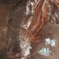
English: From the Salar de Atacama salt flat in the east to the Cordillera Domeyko mountains in the west, Sentinel-2 takes us over part of the Atacama Desert in northern Chile.
The desert runs along part of South America’s central west coast. It is considered one of the driest places on Earth. Being a ‘coastal desert’, the cold, upwelling waters in the Pacific Ocean inhibit rain from reaching the land. Instead, the winds that blow from the ocean bring fog. Because of the Atacama plateau’s high altitude, low cloud cover and lack of light pollution, it is one of the best places in the world to conduct astronomical observations and home to two major observatories. Some areas of the desert have been compared to the planet Mars, and have been used as a location for filming scenes set on the red planet. ESA has even tested a self-steering rover in the Atacama, which was selected for its similarities to martian conditions. In the lower right, the geometric shapes of large evaporation ponds dominate the Salar de Atacama –Chile’s largest salt flat. At about 3000 sq km, it is the world’s third largest salt flat as well as one of the largest active sources of lithium. From evaporation ponds like the ones pictured here, lithium bicarbonate is isolated from salt brine. Lithium is used in the manufacturing of batteries, and the increasing demand has significantly increased its value in recent years – especially for the production of electric-car batteries. This image, also featured on theEarth from Space video programme, was captured by the Copernicus Sentinel-2A satellite on 29 April 2017. |
| Datum | |
| Zdroj | http://www.esa.int/spaceinimages/Images/2017/11/Salar_de_Atacama_Chile |
| Autor | European Space Agency |
| Svolení (Užití tohoto souboru) |
contains modified Copernicus Sentinel data (2017), processed by ESA,CC BY-SA 3.0 IGO |
| Další verze |
|
| Title | Salar de Atacama, Chile |
| System | Copernicus |
| Set | Earth observation image of the week |
| Location | Atacama Desert |
| Mission | Sentinel-2 |
| Activity | Observing the Earth |
Licence
This media was created by the European Space Agency (ESA).
Where expressly so stated, images or videos are covered by the Creative Commons Attribution-ShareAlike 3.0 IGO (CC BY-SA 3.0 IGO) licence, ESA being an Intergovernmental Organisation (IGO), as defined by the CC BY-SA 3.0 IGO licence. The user is allowed under the terms and conditions of the CC BY-SA 3.0 IGO license to Reproduce, Distribute and Publicly Perform the ESA images and videos released under CC BY-SA 3.0 IGO licence and the Adaptations thereof, without further explicit permission being necessary, for as long as the user complies with the conditions and restrictions set forth in the CC BY-SA 3.0 IGO licence, these including that:
See the ESA Creative Commons copyright notice for complete information, and this article for additional details.
|
 | |
Tento soubor podléhá licenci Creative Commons Uveďte autora-Zachovejte licenci 3.0 IGO.
| ||

|
This image contains data from a satellite in the Copernicus Programme, such as Sentinel-1, Sentinel-2 or Sentinel-3. Attribution is required when using this image.
Uveďte autora: Contains modified Copernicus Sentinel data 2017
The use of Copernicus Sentinel Data is regulated under EU law (Commission Delegated Regulation (EU) No 1159/2013 and Regulation (EU) No 377/2014). Relevant excerpts:
Free access shall be given to GMES dedicated data [...] made available through GMES dissemination platforms [...].
Access to GMES dedicated data [...] shall be given for the purpose of the following use in so far as it is lawful:
GMES dedicated data [...] may be used worldwide without limitations in time.
GMES dedicated data and GMES service information are provided to users without any express or implied warranty, including as regards quality and suitability for any purpose. |
Historie souboru
Kliknutím na datum a čas se zobrazí tehdejší verze souboru.
| Datum a čas | Náhled | Rozměry | Uživatel | Komentář | |
|---|---|---|---|---|---|
| současná | 17. 11. 2017, 18:56 | | 2 000 × 2 000 (2,13 MB) | Fæ | European Space Agency, Id 386674, http://www.esa.int/spaceinimages/Images/2017/11/Salar_de_Atacama_Chile, User:Fæ/Project_list/ESA |
Využití souboru
Tento soubor používá následující stránka:
Globální využití souboru
Tento soubor využívají následující wiki:
- Využití na es.wikipedia.org
- Využití na pl.wikipedia.org