
Soubor:Roosevelt Island, Antarctica - satellite image.jpg
Velikost tohoto náhledu: 391 × 600 pixelů. Jiná rozlišení: 156 × 240 pixelů | 313 × 480 pixelů | 720 × 1 104 pixelů.
Původní soubor (720 × 1 104 pixelů, velikost souboru: 89 KB, MIME typ: image/jpeg)
| Tento soubor pochází z Wikimedia Commons. Níže jsou zobrazeny informace, které obsahuje jeho tamější stránka s popisem souboru. |
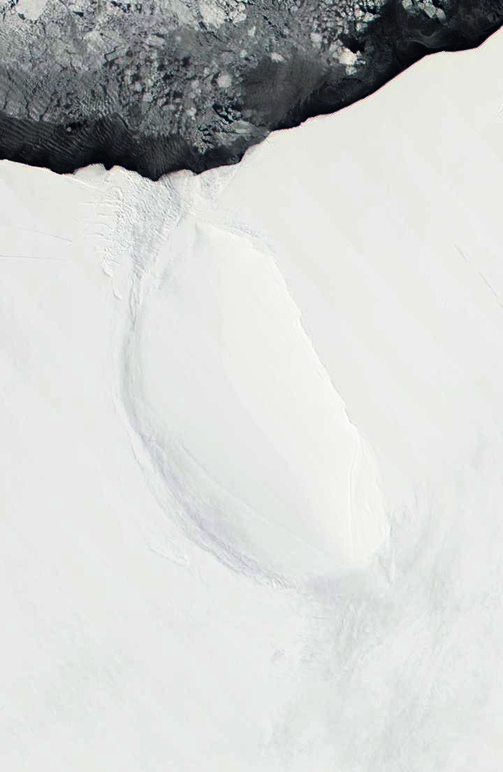
| Popis | Roosevelt Island and coast of Ross Ice Shelf, Antarctica. Darkened and cropped from a wider view of the ice shelf, a true-color image from NASA’s Moderate Resolution Imaging Spectroradiometer (MODIS) taken on November 11 and 12, 2001. |
| Datum | 11-12 November 2001 |
| Zdroj | |
| Autor |
|
| Toto je upravený obrázek, což znamená, že byl oproti původní verzi digitálně změněn. Úpravy: Cropped to focus on Roosevelt Island, and darkened. Původní verzi je možné zhlédnout zde: Ross Ice Shelf and Saunders Coast, Antarctica.A2001315.1840.250m.jpg. Úpravy provedl Avenue.
|
| This file is in the public domain in the United States because it was solely created by NASA. NASA copyright policy states that "NASA material is not protected by copyright unless noted". (See Template:PD-USGov, NASA copyright policy page or JPL Image Use Policy.) | ||
 |
Warnings:
|
Původní historie souboru
This image is a derivative work of the following images:
- File:Ross_Ice_Shelf_and_Saunders_Coast,_Antarctica.A2001315.1840.250m.jpg licensed with PD-USGov-NASA
- 2010-09-23T01:55:56Z Avenue 6800x5200 (1958559 Bytes) {{Information |Description=Ross Ice Shelf and Saunders Coast, Antarctica. Original NASA description: "This pair of true-color images from NASA’s Moderate Resolution Imaging Spectroradiometer (MODIS) show the Ross Ice Shelf
Uploaded with derivativeFX
Historie souboru
Kliknutím na datum a čas se zobrazí tehdejší verze souboru.
| Datum a čas | Náhled | Rozměry | Uživatel | Komentář | |
|---|---|---|---|---|---|
| současná | 23. 9. 2010, 04:13 | | 720 × 1 104 (89 KB) | Avenue | Darkened to show island better. |
| 23. 9. 2010, 04:12 |  | 720 × 1 104 (58 KB) | Avenue | {{Information |Description=Roosevelt Island and coast of Ross Ice Shelf, Antarctica. Cropped from wider view of the ice shelf, a true-color images from NASA’s Moderate Resolution Imaging Spectroradiometer (MODIS) on November 11 and 12, 2001. |Source=*[ |
Využití souboru
Tento soubor používá následující stránka:
Globální využití souboru
Tento soubor využívají následující wiki:
- Využití na ast.wikipedia.org
- Využití na az.wikipedia.org
- Využití na bg.wikipedia.org
- Využití na ca.wikipedia.org
- Využití na ceb.wikipedia.org
- Využití na de.wikipedia.org
- Využití na el.wikipedia.org
- Využití na en.wikipedia.org
- Využití na es.wikipedia.org
- Využití na fa.wikipedia.org
- Využití na fi.wikipedia.org
- Využití na fr.wikipedia.org
- Využití na gl.wikipedia.org
- Využití na he.wikipedia.org
- Využití na it.wikipedia.org
- Využití na ja.wikipedia.org
- Využití na lv.wikipedia.org
- Využití na nl.wikipedia.org
- Využití na nn.wikipedia.org
- Využití na no.wikipedia.org
- Využití na pl.wikipedia.org
- Využití na ru.wikipedia.org
- Využití na sv.wikipedia.org
- Využití na uk.wikipedia.org
- Využití na www.wikidata.org
- Využití na zh.wikipedia.org