
Soubor:Rakahanga.jpg
Velikost tohoto náhledu: 509 × 600 pixelů. Jiná rozlišení: 204 × 240 pixelů | 634 × 747 pixelů.
Původní soubor (634 × 747 pixelů, velikost souboru: 131 KB, MIME typ: image/jpeg)
| Tento soubor pochází z Wikimedia Commons. Níže jsou zobrazeny informace, které obsahuje jeho tamější stránka s popisem souboru. |
Popis
| Popis |
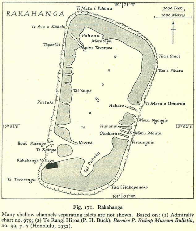
English: Map of Rakahanga Atoll, Northern Cook Islands |
| Datum | |
| Zdroj | http://www.lib.utexas.edu/maps/historical/pacific_islands_1943_1945/rakahanga.jpg |
| Autor | US Army |
Licence
This file is in the public domain because it has been taken from a collection of public domain maps at the University of Texas Library
|
Historie souboru
Kliknutím na datum a čas se zobrazí tehdejší verze souboru.
| Datum a čas | Náhled | Rozměry | Uživatel | Komentář | |
|---|---|---|---|---|---|
| současná | 10. 8. 2008, 19:19 | | 634 × 747 (131 KB) | Ratzer | {{Information |Description={{en|1=Map of Rakahanga Atoll, Northern Cook Islands}} |Source=http://www.lib.utexas.edu/maps/historical/pacific_islands_1943_1945/rakahanga.jpg |Author=US Army |Date=1943 |Permission= |other_versions= }} {{ImageUpload|full}} |
Využití souboru
Tento soubor používá následující stránka:
Globální využití souboru
Tento soubor využívají následující wiki:
- Využití na bcl.wikipedia.org
- Využití na ca.wikipedia.org
- Využití na ceb.wikipedia.org
- Využití na de.wikipedia.org
- Využití na en.wikipedia.org
- Využití na es.wikipedia.org
- Využití na fr.wikipedia.org
- Využití na id.wikipedia.org
- Využití na is.wikipedia.org
- Využití na it.wikipedia.org
- Využití na ka.wikipedia.org
- Využití na la.wikipedia.org
- Využití na lt.wikipedia.org
- Využití na mt.wikipedia.org
- Využití na ru.wikipedia.org
- Využití na simple.wikipedia.org
- Využití na su.wikipedia.org
- Využití na sv.wikipedia.org
- Využití na tr.wikipedia.org
- Využití na www.wikidata.org