
Soubor:Pakistan-Waziristan-Map.png

Velikost tohoto náhledu: 606 × 599 pixelů. Jiná rozlišení: 243 × 240 pixelů | 486 × 480 pixelů | 700 × 692 pixelů.
Původní soubor (700 × 692 pixelů, velikost souboru: 96 KB, MIME typ: image/png)
| Tento soubor pochází z Wikimedia Commons. Níže jsou zobrazeny informace, které obsahuje jeho tamější stránka s popisem souboru. |
Popis
| Popis |
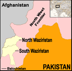
English: Map showing location of North and South Waziristan in northern Pakistan and bordering on Afghanistan |
||||
| Datum | |||||
| Zdroj | drawn by uploader using Jasc Paint Shop, using as insert map a reference map in Public Domain from the United States Central Intelligence Agency | ||||
| Autor | Thaddeus P. Bejnar | ||||
| Svolení (Užití tohoto souboru) |
Public Domain, I (Thaddeus P. Bejnar) hereby release this work to the Public Domain | ||||
| Další verze |
|


.svg)

.png)


.svg)


.svg)


_Territory_Change_2014-2016.gif)

_(within_Northern_Syria).svg)


.png)
.svg)


_map.png)
.svg)


.svg)


Licence
| Já, autor tohoto díla, jej tímto uvolňuji jako volné dílo, a to celosvětově. V některých zemích to není podle zákona možné; v takovém případě: Poskytuji komukoli právo užívat toto dílo za libovolným účelem, a to bezpodmínečně s výjimkou podmínek vyžadovaných zákonem. |
Historie souboru
Kliknutím na datum a čas se zobrazí tehdejší verze souboru.
| Datum a čas | Náhled | Rozměry | Uživatel | Komentář | |
|---|---|---|---|---|---|
| současná | 7. 11. 2006, 23:59 | | 700 × 692 (96 KB) | Bejnar | {{Information |Description=Map showing location of North and South Waziristan in northern Pakistan and bordering on Afghanistan |Source=drawn by uploader using Jasc Paint Shop |Date=7 November 2006 |Author=Thaddeus P. Bejnar |Permission=Public Domain, I ( |
Využití souboru
Tento soubor používá následující stránka:
Globální využití souboru
Tento soubor využívají následující wiki:
- Využití na ar.wikipedia.org
- Využití na ca.wikipedia.org
- Využití na cy.wikipedia.org
- Využití na de.wikinews.org
- Využití na en.wikinews.org
- 17 troops killed in bombing on Afghanistan-Pakistan border; Separate bombing kills dozens of civilians
- High level al-Qaeda leader reported dead
- Pakistani military launches ground offensive against Taliban and al-Qaeda
- Pakistan: Twelve militants killed in recent fighting
- Suspected US drone attack kills at least fourteen in Pakistan
- Využití na fr.wikipedia.org
- Využití na it.wikipedia.org
- Využití na nl.wikipedia.org
- Využití na pt.wikipedia.org
- Využití na pt.wikinews.org