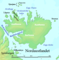
Soubor:Nordaustlandet labelled.png
Nordaustlandet_labelled.png (524 × 528 pixelů, velikost souboru: 119 KB, MIME typ: image/png)
Historie souboru
Kliknutím na datum a čas se zobrazí tehdejší verze souboru.
| Datum a čas | Náhled | Rozměry | Uživatel | Komentář | |
|---|---|---|---|---|---|
| současná | 29. 7. 2006, 04:47 |  | 524 × 528 (119 KB) | TheGrappler | Remove cursor |
| 29. 7. 2006, 03:08 |  | 524 × 528 (119 KB) | TheGrappler | Correct spelling | |
| 29. 7. 2006, 02:40 |  | 524 × 528 (119 KB) | TheGrappler | == Summary == {{English}} Map detailing the marine features of Spitsbergen in the Svalbard archipelago. Settlements and mountains are indicated and labelled. See also Image:Spitsbergen mountains and marine features labelled.png. Locations were labell |
Využití souboru
Tento soubor používá následující stránka:
Globální využití souboru
Tento soubor využívají následující wiki:
- Využití na af.wikipedia.org
- Využití na ast.wikipedia.org
- Využití na az.wikipedia.org
- Využití na ca.wikipedia.org
- Využití na ceb.wikipedia.org
- Využití na cy.wikipedia.org
- Využití na da.wikipedia.org
- Využití na de.wikipedia.org
- Využití na el.wikipedia.org
- Využití na en.wikipedia.org
- Nordaustlandet
- Wahlenbergfjorden
- Austfonna
- Wilhelm Island
- Hinlopen Strait
- Sjuøyane
- Vestfonna
- Augusta Bay (Nordaustlandet)
- Whalers Bay (Svalbard)
- Gustav Adolf Land
- Gustav V Land
- Bråsvellbreen
- Leighbreen
- Orvin Land
- Duvefjorden
- Rijpfjorden
- Etonbreen
- Prins Oscars Land
- Nordkappsundet
- Nordkapp (Nordaustlandet)
- Adlersparrefjorden
- Finn Malmgren Fjord
- Glenhalvøya
- Murchisonfjorden
- Lady Franklinfjorden
Zobrazit další globální využití tohoto souboru.

