
Soubor:NPS glacier-map.jpg
Velikost tohoto náhledu: 548 × 599 pixelů. Jiná rozlišení: 219 × 240 pixelů | 439 × 480 pixelů | 702 × 768 pixelů | 936 × 1 024 pixelů | 1 872 × 2 048 pixelů | 3 311 × 3 622 pixelů.
Původní soubor (3 311 × 3 622 pixelů, velikost souboru: 2,06 MB, MIME typ: image/jpeg)
| Tento soubor pochází z Wikimedia Commons. Níže jsou zobrazeny informace, které obsahuje jeho tamější stránka s popisem souboru. |
Popis
| Popis |
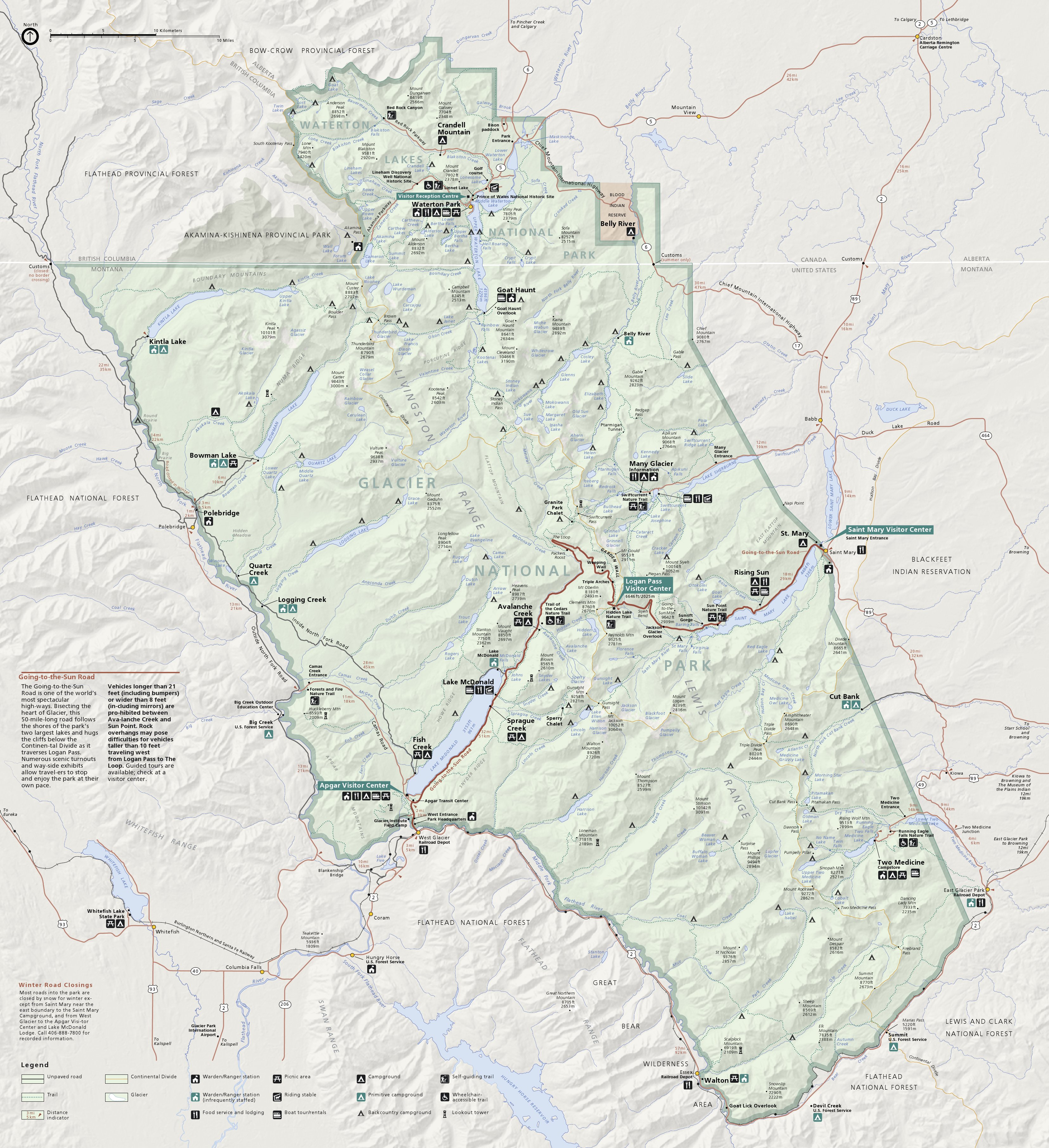
English: Official Glacier National Park map from the park brochure. It also shows Canada’s Waterton Lakes National Park. |
| Datum | |
| Zdroj | U.S. National Park Service (http://npmaps.com/wp-content/uploads/glacier-map.jpg) |
| Autor | U.S. National Park Service, restoration/cleanup by Matt Holly |
| Další verze |
 |
Licence
| This image or media file contains material based on a work of a National Park Service employee, created as part of that person's official duties. As a work of the U.S. federal government, such work is in the public domain in the United States. See the NPS website and NPS copyright policy for more information. |
Historie souboru
Kliknutím na datum a čas se zobrazí tehdejší verze souboru.
| Datum a čas | Náhled | Rozměry | Uživatel | Komentář | |
|---|---|---|---|---|---|
| současná | 16. 5. 2017, 23:39 | | 3 311 × 3 622 (2,06 MB) | RKBot | =={{int:filedesc}}== {{Information |description= {{en|1=Official Glacier National Park map from the park brochure. It also shows Canada’s Waterton Lakes National Park.}} |date= 2013-10-30 |source= U.S. National Park Service (http://npmaps.com/wp-cont... |
Využití souboru
Tento soubor používá následující stránka:
Globální využití souboru
Tento soubor využívají následující wiki:
- Využití na www.wikidata.org