
Soubor:MiG Alley Map.JPG
Větší rozlišení není k dispozici
MiG_Alley_Map.JPG (348 × 375 pixelů, velikost souboru: 52 KB, MIME typ: image/jpeg)
| Tento soubor pochází z Wikimedia Commons. Níže jsou zobrazeny informace, které obsahuje jeho tamější stránka s popisem souboru. |
Popis

|
K tomuto obrázku existuje vektorová verze (v SVG). Pokud je lepší, používejte raději tu.
File:MiG Alley Map.JPG → File:MiG Alley Map (en).svg
Podrobnější informace o vektorové grafice najdete na stránce Commons:Transition to SVG. Také si můžete přečíst informace o podpoře formátu SVG v MediaWiki. |
.svg) |
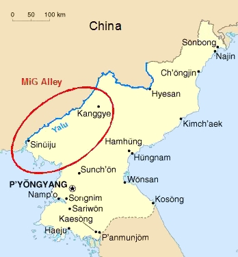
| Popis |
Deutsch: Das Gebiet an der chinesisch-nordkoreanischen Grenze, das während des Koreakrieges (1950-53) als "MiG Alley" berühmt wurde.
English: The area called "MiG Alley" during the Korean War (1950-53) on the Chinese-North Korean border. |
| Datum | 01.06.2006 |
| Zdroj | Vlastní dílo based on CIA Factbook map on North Korea |
| Autor | Triggerhappy |
| Další verze |
Chinese: Russian: Russian: |
Licence
| Já, autor tohoto díla, jej tímto uvolňuji jako volné dílo, a to celosvětově. V některých zemích to není podle zákona možné; v takovém případě: Poskytuji komukoli právo užívat toto dílo za libovolným účelem, a to bezpodmínečně s výjimkou podmínek vyžadovaných zákonem. |
Historie souboru
Kliknutím na datum a čas se zobrazí tehdejší verze souboru.
| Datum a čas | Náhled | Rozměry | Uživatel | Komentář | |
|---|---|---|---|---|---|
| současná | 27. 1. 2012, 22:09 | | 348 × 375 (52 KB) | Hohum | Cleanup |
| 1. 6. 2006, 19:27 |  | 348 × 375 (21 KB) | Triggerhappy | {{Information |Description=*'''de:''' Das Gebiet an der chinesisch-nordkoreanischen Grenze, das während des Koreakrieges (1950-53) als "MiG Alley" berühmt wurde. *'''en:''' The area called "MiG Alley" during the Korean War (1950-53) on the chinese-north |
Využití souboru
Tento soubor nepoužívá žádná stránka.
Globální využití souboru
Tento soubor využívají následující wiki:
- Využití na zh.wikipedia.org