
Soubor:MSH80 eruption mount st helens 05-18-80.jpg

Velikost tohoto náhledu: 399 × 600 pixelů. Jiná rozlišení: 160 × 240 pixelů | 319 × 480 pixelů | 511 × 768 pixelů | 681 × 1 024 pixelů | 1 362 × 2 048 pixelů | 2 994 × 4 500 pixelů.
Původní soubor (2 994 × 4 500 pixelů, velikost souboru: 1,43 MB, MIME typ: image/jpeg)
| Tento soubor pochází z Wikimedia Commons. Níže jsou zobrazeny informace, které obsahuje jeho tamější stránka s popisem souboru. |
| Popis |
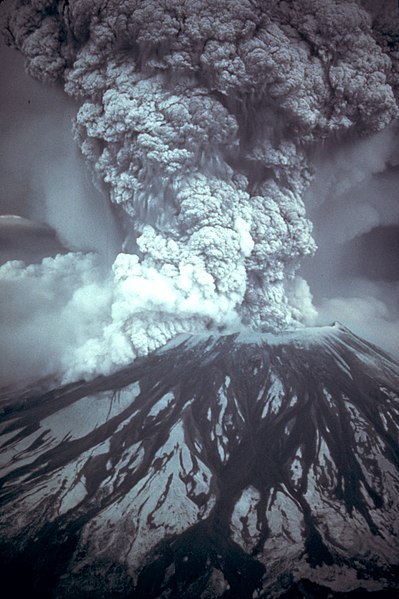
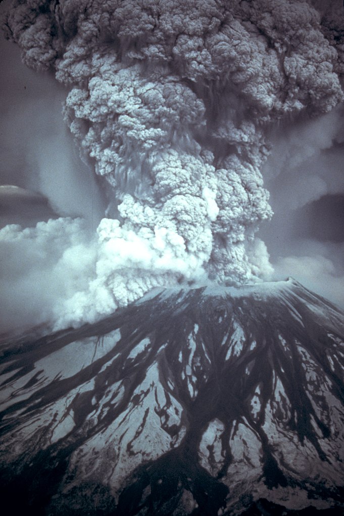
English: On May 18, 1980, at 8:32 a.m. Pacific Daylight Time, a magnitude 5.1 earthquake shook Mount St. Helens. The bulge and surrounding area slid away in a gigantic rockslide and debris avalanche, releasing pressure, and triggering a major pumice and ash eruption of the volcano. Thirteen-hundred feet (400 meters) of the peak collapsed or blew outwards. As a result, 24 square miles (62 square kilometers) of valley was filled by a debris avalanche, 250 square miles (650 square kilometers) of recreation, timber, and private lands were damaged by a lateral blast, and an estimated 200 million cubic yards (150 million cubic meters) of material was deposited directly by lahars (volcanic mudflows) into the river channels. Sixty-one people were killed or are still missing.
USGS Photograph taken on May 18, 1980, by Austin Post.
Català: El 18 de maig, a les 8:32 a. m. Temps del Pacífic, un terratrèmol de una magnitud de 5,1 va fer trontollar la muntanya St. Helens. La protuberància l'àrea circumdant relliscà en una gegantina esllavissada de roques i un allau de rocam, alliberant la pressió, desencadenà una erupció de pedra tosca i cendra del volcà. 400 metres del puig van col·lapsar o van sortir volant. Com a resultat 62 quilometres quadrats de la vall van ser emplenats per la runa, 650 quilometres quadrats de llocs d'esbarjo, bosc, i finques privades van ser damnificades per una ràfega lateral, i una quantitat estimada en 150 milions de metres cúbics de material van ser dipositats per corrents de fang volcànic en els canals del riu. Cinquanta set persones van morir o han desaparegut (18 de Maig de 1980, Austin Post, USGS)
Español: Erupción del Monte Santa Helena
Français : Le 18 mai 1980, à 8h32 minutes (heure du Pacifique), un tremblement de terre de 5,1 sur l'échelle de Richter secoue le Mont Saint Helens, marquant le début de l'éruption du mont Saint Helens en 1980. |
|||||||||||||
| Datum | ||||||||||||||
| Zdroj |
Huge tif converted to jpeg and caption from USGS Mount St. Helens, Washington May 18, 1980 Eruption Images |
|||||||||||||
| Autor |
|
|||||||||||||
| Svolení (Užití tohoto souboru) |
|
|||||||||||||
| Další verze |
 |
|||||||||||||
Historie souboru
Kliknutím na datum a čas se zobrazí tehdejší verze souboru.
| Datum a čas | Náhled | Rozměry | Uživatel | Komentář | |
|---|---|---|---|---|---|
| současná | 28. 11. 2007, 13:30 | | 2 994 × 4 500 (1,43 MB) | CarolSpears | {{Information |Description={{en|On May 18, 1980, at 8:32 a.m. Pacific Daylight Time, a magnitude 5.1 earthquake shook Mount St. Helens. The bulge and surrounding area slid away in a gigantic rockslide and debris avalanche, releasing pressure, and triggeri |
Využití souboru
Tento soubor používá následujících 5 stránek:
Globální využití souboru
Tento soubor využívají následující wiki:
- Využití na af.wikipedia.org
- Využití na ang.wikipedia.org
- Využití na ar.wikipedia.org
- Využití na ast.wikipedia.org
- Využití na az.wikipedia.org
- Využití na ca.wikipedia.org
- Využití na co.wikipedia.org
- Využití na da.wikipedia.org
- Využití na de.wikipedia.org
- Využití na el.wikipedia.org
- Využití na en.wikipedia.org
- Mount St. Helens
- Wikipedia:Selected anniversaries/May 18
- Wikipedia:Recent additions 9
- Wikipedia:Today's featured article/September 2004
- Wikipedia:Today's featured article/September 13, 2004
- 1980 United States Senate elections
- History of Washington (state)
- Prediction of volcanic activity
- 1980 in the United States
- User:Asenine/FePi/Feb07
- Portal:United States/Anniversaries/May
- Portal:United States/Anniversaries/All
- Geology of the Pacific Northwest
- Portal:United States/Anniversaries/May/May 18
- Reid Blackburn
- Portal:Oregon/Selected article
- User:Anynobody/eruption
- Portal:Oregon/Selected article/22
- Wikipedia:Recent additions/2004/May
- Talk:Mount St. Helens/Archive 2
- 1980 United States Senate election in Oregon
- Portal:Trains/Did you know/August 2010
- Wikipedia:Main Page history/2013 May 18
- Barry Voight
- Symphony No. 50 (Hovhaness)
Zobrazit další globální využití tohoto souboru.