
Soubor:Lotharingia-1508.jpg

Velikost tohoto náhledu: 437 × 599 pixelů. Jiná rozlišení: 175 × 240 pixelů | 350 × 480 pixelů | 560 × 768 pixelů | 747 × 1 024 pixelů | 1 521 × 2 086 pixelů.
Původní soubor (1 521 × 2 086 pixelů, velikost souboru: 2,05 MB, MIME typ: image/jpeg)
| Tento soubor pochází z Wikimedia Commons. Níže jsou zobrazeny informace, které obsahuje jeho tamější stránka s popisem souboru. |
Popis
| Popis |
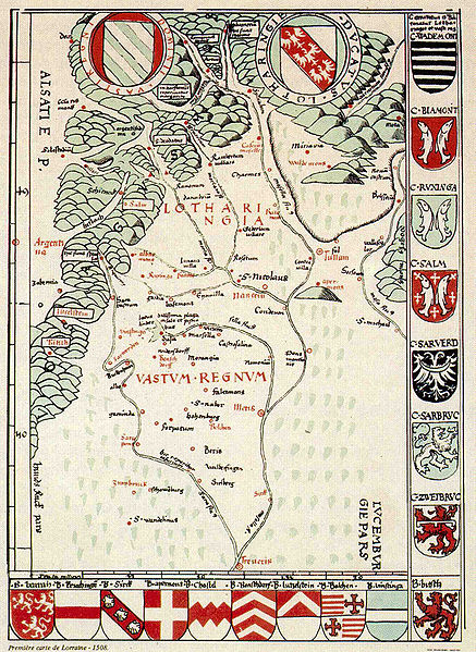
Français : Première carte connue de la Lorraine. (note: Le nord est en bas) English: First known map of Lorraine (North is at bottom) Deutsch: Erste bekannte Karte Lothringens (Norden ist unten) |
|||||||||||||||||||||||
| Datum | cca 1508 | |||||||||||||||||||||||
| Zdroj | Bibliothèque municipale de Saint-Dié-des-Vosges (catalogue de l'exposition America, L'amérique est née à Saint-Dié-des-Vosges en 1507) - 1992 | |||||||||||||||||||||||
| Autor |
|
|||||||||||||||||||||||

|
Toto dílo je volné také v zemích, jejichž právní řád chrání majetková autorská práva po dobu života autora a 100 let po jeho smrti. | |
| Bylo zjištěno, že u tohoto souboru nejsou známa žádná omezení daná autorským právem a právy s ním souvisejícími. | |
Historie souboru
Kliknutím na datum a čas se zobrazí tehdejší verze souboru.
| Datum a čas | Náhled | Rozměry | Uživatel | Komentář | |
|---|---|---|---|---|---|
| současná | 14. 5. 2006, 11:03 | | 1 521 × 2 086 (2,05 MB) | Ji-Elle | {{Information| |Description=Première carte connue de la Lorraine |Source=Bibliothèque municipale de Saint-Dié-des-Vosges (cataloge de l'exposition America, 1992) |Date=1508 (?) |Author=Martin Waldseemüller |Permission= |other_versions= }} {{PD-old}} |
Využití souboru
Tento soubor používá následující stránka:
Globální využití souboru
Tento soubor využívají následující wiki:
- Využití na als.wikipedia.org
- Využití na de.wikipedia.org
- Využití na en.wikipedia.org
- Využití na eo.wikipedia.org
- Využití na es.wikipedia.org
- Využití na fr.wikipedia.org
- Využití na hu.wikipedia.org
- Využití na hu.wikibooks.org
- Využití na la.wikipedia.org
- Využití na ms.wikipedia.org
- Využití na sr.wikipedia.org