
Soubor:Lithuania Minor.png
Velikost tohoto náhledu: 800 × 519 pixelů. Jiná rozlišení: 320 × 208 pixelů | 640 × 415 pixelů | 1 024 × 665 pixelů | 1 471 × 955 pixelů.
Původní soubor (1 471 × 955 pixelů, velikost souboru: 3,56 MB, MIME typ: image/png)
| Tento soubor pochází z Wikimedia Commons. Níže jsou zobrazeny informace, které obsahuje jeho tamější stránka s popisem souboru. |
Popis
| Popis |
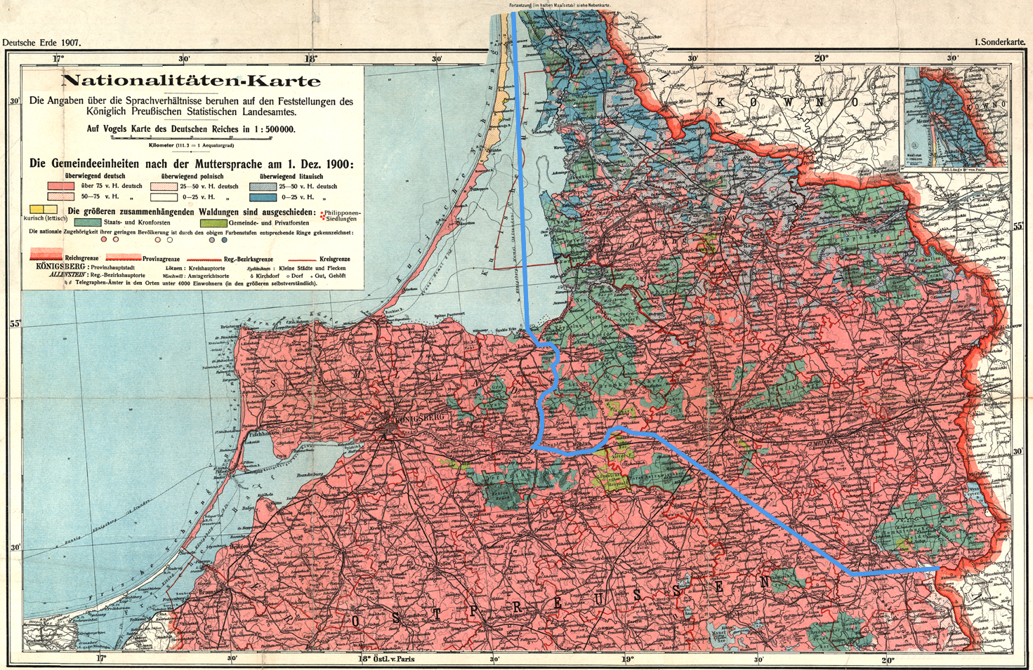
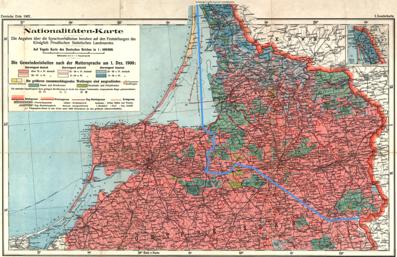
English: The language situation in Lithuania Minor (German: Kleinlitauen) in 1900. The blue line indicates the extent of the Lithuanian language are in 1876 as described by Friedrich Kurschat in 1876:
|
| Datum | (UTC) |
| Zdroj | |
| Autor |
|
| Toto je upravený obrázek, což znamená, že byl oproti původní verzi digitálně změněn. Úpravy: Added the 1876 border between the Lithuanian and German language areas as described by Friedrich Kurschat in 1876; cropped. Původní verzi je možné zhlédnout zde: Ethnic map East Prussia 1907.jpeg. Úpravy provedl Fentener van Vlissingen.
|
Licence
|
Autor zemřel v roce 1952, takže toto dílo je volné také v zemích, jejichž právní řád chrání majetková autorská práva po dobu života autora a 70 let po jeho smrti. Toto dílo je ve Spojených státech amerických dílem volným (public domain), protože tam bylo registrováno u U.S. Copyright Office nebo zveřejněno před 1. lednem 1929. | |
| Bylo zjištěno, že u tohoto souboru nejsou známa žádná omezení daná autorským právem a právy s ním souvisejícími. | |
Původní historie souboru
This image is a derivative work of the following images:
- File:Ethnic_map_East_Prussia_1907.jpeg licensed with PD-old
- 2009-04-25T16:53:31Z Fentener van Vlissingen 1682x2139 (4979293 Bytes) == Summary == {{Information |Description={{de|Nationalitäten-Karte der Provinz Ostpreussen / auf Grund amtlicher Angaben entworfen von Paul Langhans}} {{en|Nationalities map of the Province of East Prussia / on the basis of
Uploaded with derivativeFX
Historie souboru
Kliknutím na datum a čas se zobrazí tehdejší verze souboru.
| Datum a čas | Náhled | Rozměry | Uživatel | Komentář | |
|---|---|---|---|---|---|
| současná | 19. 9. 2009, 18:08 | | 1 471 × 955 (3,56 MB) | Fentener van Vlissingen | {{Information |Description={{en|The language situation in Lithuania Minor (German: ''Kleinlitauen'') in 1900. The blue line indicates the extent of the Lithuanian language are in 1876 as described by Friedrich Kurschat in 1876: :''Die Grenze des littauis |
Využití souboru
Tento soubor nepoužívá žádná stránka.
Globální využití souboru
Tento soubor využívají následující wiki:
- Využití na de.wikipedia.org
- Využití na lv.wikipedia.org
- Využití na uk.wikipedia.org