
Soubor:Kuwaiti islands.jpg

Velikost tohoto náhledu: 667 × 600 pixelů. Jiná rozlišení: 267 × 240 pixelů | 534 × 480 pixelů | 854 × 768 pixelů | 1 139 × 1 024 pixelů | 2 277 × 2 048 pixelů | 4 242 × 3 815 pixelů.
Původní soubor (4 242 × 3 815 pixelů, velikost souboru: 5,39 MB, MIME typ: image/jpeg)
| Tento soubor pochází z Wikimedia Commons. Níže jsou zobrazeny informace, které obsahuje jeho tamější stránka s popisem souboru. |
Popis
| Kuwaiti islands | |
|---|---|
| Fotograf |
Envisat satellite |
| Název |
Kuwaiti islands |
| Popis |
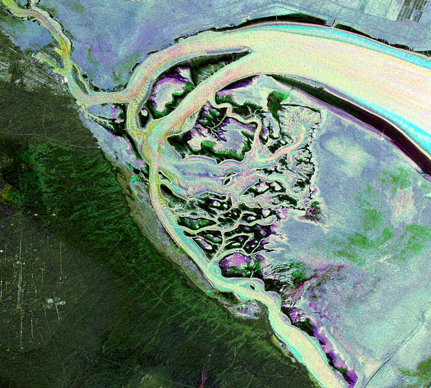
English: This Envisat image features the Kuwait islands of Warbah and Bubiyan, located at the head of the Persian Gulf.
What appears to be water across the top and right side of the image (lilac, green and blue) is land. The brighter yellow, aqua and pink colours represent water. Here, the water currents in these channels can be observed thanks to the radar imagery as they flow out into the gulf. The image was created by combining three Advanced Synthetic Aperture Radar (ASAR) acquisitions (22 August 2009, 26 September 2009 and 31 October 2009) taken over the same area. The colours in the image result from variations in the surface that occurred between acquisitions. |
| Depicted place | Kuvajt |
| Datum | mezi 22. srpnem 2009 a 31. říjnem 2009 |
| Sbírka | European Space Agency |
| Inventární číslo |
236846 |
| Způsob získání | ESA |
| Zdroj | http://www.esa.int/spaceinimages/Images/2010/02/Kuwaiti_islands |
Licence
Tento soubor podléhá licenci Creative Commons Uveďte autora-Zachovejte licenci 3.0 IGO.
- Dílo smíte:
- šířit – kopírovat, distribuovat a sdělovat veřejnosti
- upravovat – pozměňovat, doplňovat, využívat celé nebo částečně v jiných dílech
- Za těchto podmínek:
- uveďte autora – Máte povinnost uvést autorství, poskytnout odkaz na licenci a uvést, pokud jste provedli změny. Toho můžete docílit jakýmkoli rozumným způsobem, avšak ne způsobem naznačujícím, že by poskytovatel licence schvaloval nebo podporoval vás nebo vaše užití díla.
- zachovejte licenci – Pokud tento materiál jakkoliv upravíte, přepracujete nebo použijete ve svém díle, musíte své příspěvky šířit pod stejnou nebo slučitelnou licencí jako originál.
Historie souboru
Kliknutím na datum a čas se zobrazí tehdejší verze souboru.
| Datum a čas | Náhled | Rozměry | Uživatel | Komentář | |
|---|---|---|---|---|---|
| současná | 27. 2. 2017, 09:12 | | 4 242 × 3 815 (5,39 MB) | Revent | =={{int:filedesc}}== {{Photograph |photographer = Envisat satellite |title = Kuwaiti islands |description = {{en|1=This Envisat image features the Kuwait islands of Warbah and Bubiyan, located at the head of the Persian Gul... |
Využití souboru
Tento soubor používá následující stránka:
Globální využití souboru
Tento soubor využívají následující wiki:
- Využití na de.wikipedia.org
- Využití na en.wikipedia.org
- Využití na es.wikipedia.org
- Využití na fr.wikipedia.org
- Využití na pt.wikipedia.org
- Využití na uk.wikipedia.org