
Soubor:ISS-36 Salton Trough.jpg

Velikost tohoto náhledu: 800 × 532 pixelů. Jiná rozlišení: 320 × 213 pixelů | 640 × 426 pixelů | 1 024 × 681 pixelů | 1 280 × 852 pixelů | 2 560 × 1 703 pixelů | 4 256 × 2 832 pixelů.
Původní soubor (4 256 × 2 832 pixelů, velikost souboru: 2,82 MB, MIME typ: image/jpeg)
| Tento soubor pochází z Wikimedia Commons. Níže jsou zobrazeny informace, které obsahuje jeho tamější stránka s popisem souboru. |
Popis
| Popis |
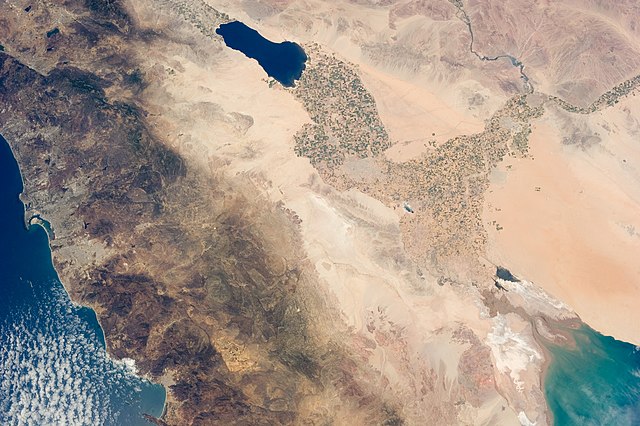
English: The Salton Trough is featured in this image photographed by an Expedition 36 crew member on the International Space Station.
|
| Datum | |
| Zdroj | http://spaceflight.nasa.gov/gallery/images/station/crew-36/html/iss036e011034.html |
| Autor | NASA |
Tento mediální soubor byl katalogizován v Johnsonově vesmírném středisku amerického Národního úřadu pro letectví a kosmonautiku (NASA)pod Photo ID: ISS036-E-011034. Toto oznámení nepopisuje autorskoprávní status tohoto souboru. Stále je vyžadován běžný popisek licence. Další informace najdete na Commons:Licencování. Jiné jazyky:
|
Licence
This file is in the public domain in the United States because it was created by the Image Science & Analysis Laboratory, of the NASA Johnson Space Center. NASA copyright policy states that "NASA material is not protected by copyright unless noted". (NASA media use guidelines or Conditions of Use of Astronaut Photographs).
Photo source: ISS036-E-11034.
|
Historie souboru
Kliknutím na datum a čas se zobrazí tehdejší verze souboru.
| Datum a čas | Náhled | Rozměry | Uživatel | Komentář | |
|---|---|---|---|---|---|
| současná | 18. 8. 2013, 01:41 | | 4 256 × 2 832 (2,82 MB) | Ras67 | 180 degree rotated high quality rendering from NASA's raw data |
| 30. 7. 2013, 03:30 |  | 4 256 × 2 832 (1,55 MB) | Ras67 | == {{int:filedesc}} == {{Information |Description={{en|1=The Salton Trough is featured in this image photographed by an Expedition 36 crew member on the International Space Station. * The Imperial and Coachella Valleys of southern California – and th... |
Využití souboru
Tento soubor používá následující stránka:
Globální využití souboru
Tento soubor využívají následující wiki:
- Využití na en.wikipedia.org
- Využití na he.wikipedia.org