
Soubor:Haupteinheitengruppen Tiefland Westteil.png
Velikost tohoto náhledu: 647 × 599 pixelů. Jiná rozlišení: 259 × 240 pixelů | 518 × 480 pixelů | 1 000 × 926 pixelů.
Původní soubor (1 000 × 926 pixelů, velikost souboru: 1,22 MB, MIME typ: image/png)
| Tento soubor pochází z Wikimedia Commons. Níže jsou zobrazeny informace, které obsahuje jeho tamější stránka s popisem souboru. |
Popis
| Popis |
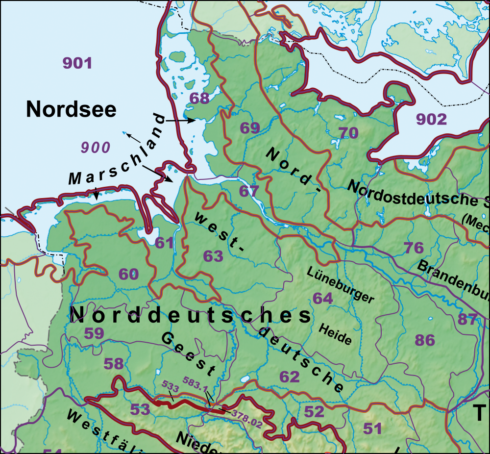
Deutsch: Haupteinheitengruppen im Westen des Norddeutschen Tieflandes nebst Lössbörden |
| Zdroj | |
| Autor | |
| Další verze | Siehe komplette Galerie |
Licence
Já, držitel autorských práv k tomuto dílu, ho tímto zveřejňuji za podmínek následujících licencí:

|
Tento dokument smí být kopírován, šířen nebo upravován podle podmínek Svobodné licence GNU pro dokumenty verze 1.2 nebo libovolné vyšší verze publikované nadací Free Software Foundation. Dokument nemá neměnné části ani texty na předním či zadním přebalu. Kopie textu licence je k dispozici v oddíle nazvaném GNU Free Documentation License. |
Tento soubor podléhá licenci Creative Commons Uveďte autora-Zachovejte licenci 3.0 Unported
- Dílo smíte:
- šířit – kopírovat, distribuovat a sdělovat veřejnosti
- upravovat – pozměňovat, doplňovat, využívat celé nebo částečně v jiných dílech
- Za těchto podmínek:
- uveďte autora – Máte povinnost uvést autorství, poskytnout odkaz na licenci a uvést, pokud jste provedli změny. Toho můžete docílit jakýmkoli rozumným způsobem, avšak ne způsobem naznačujícím, že by poskytovatel licence schvaloval nebo podporoval vás nebo vaše užití díla.
- zachovejte licenci – Pokud tento materiál jakkoliv upravíte, přepracujete nebo použijete ve svém díle, musíte své příspěvky šířit pod stejnou nebo slučitelnou licencí jako originál.
Můžete si zvolit libovolnou z těchto licencí.
Historie souboru
Kliknutím na datum a čas se zobrazí tehdejší verze souboru.
| Datum a čas | Náhled | Rozměry | Uživatel | Komentář | |
|---|---|---|---|---|---|
| současná | 23. 12. 2020, 20:55 | | 1 000 × 926 (1,22 MB) | Elop | |
| 26. 12. 2014, 01:20 |  | 1 000 × 926 (1,19 MB) | Elop | war falscher Ausschnitt | |
| 25. 12. 2014, 21:01 |  | 1 000 × 926 (1,14 MB) | Elop | update | |
| 22. 11. 2014, 15:49 |  | 1 000 × 924 (1 009 KB) | Elop | update | |
| 1. 7. 2012, 17:34 |  | 1 000 × 924 (1,07 MB) | Elop | update | |
| 25. 10. 2011, 02:32 |  | 1 000 × 896 (2,57 MB) | Elop | k | |
| 24. 10. 2011, 18:28 |  | 1 000 × 889 (2,55 MB) | Elop | Grenzkorrektur Weser/Aller | |
| 24. 10. 2011, 17:25 |  | 1 000 × 876 (2,51 MB) | Elop | smaller | |
| 24. 10. 2011, 14:48 |  | 1 000 × 1 289 (3,7 MB) | Elop | more details | |
| 2. 10. 2011, 16:25 |  | 913 × 999 (2,61 MB) | Elop | == {{int:filedesc}} == {{Information |Description={{de|1=Haupteinheitengruppen im Westen des Norddeutschen Tieflandes nebst Lössbörden}} |Source=*[[:Image:Deutschland_Naturräumliche Haupteinheiten.png|Deutschland_Naturräumli |
Využití souboru
Tento soubor používá následující stránka:
Globální využití souboru
Tento soubor využívají následující wiki:
- Využití na de.wikipedia.org
- Norddeutsches Tiefland
- Naturräumliche Großregionen Deutschlands
- Dümmer-Geestniederung
- Ostfriesisch-Oldenburgische Geest
- Hohe Heide
- Südheide
- Luheheide
- Benutzer:Aeroid/List DE NI-WL
- Benutzer:Aeroid/Geo North European Plain
- Benutzer:Aeroid/Natural region DE 64
- Benutzer:Aeroid/List DE NI Natural region
- Benutzer:Aeroid/List DE HH-unmittelbar
- Využití na en.wikipedia.org
- Využití na nds.wikipedia.org
- Využití na www.wikidata.org