
Soubor:Great Basin National Park map 2007.04.png

Velikost tohoto náhledu: 679 × 600 pixelů. Jiná rozlišení: 272 × 240 pixelů | 543 × 480 pixelů | 869 × 768 pixelů | 1 159 × 1 024 pixelů | 1 647 × 1 455 pixelů.
Původní soubor (1 647 × 1 455 pixelů, velikost souboru: 649 KB, MIME typ: image/png)
| Tento soubor pochází z Wikimedia Commons. Níže jsou zobrazeny informace, které obsahuje jeho tamější stránka s popisem souboru. |
Popis
| Popis |
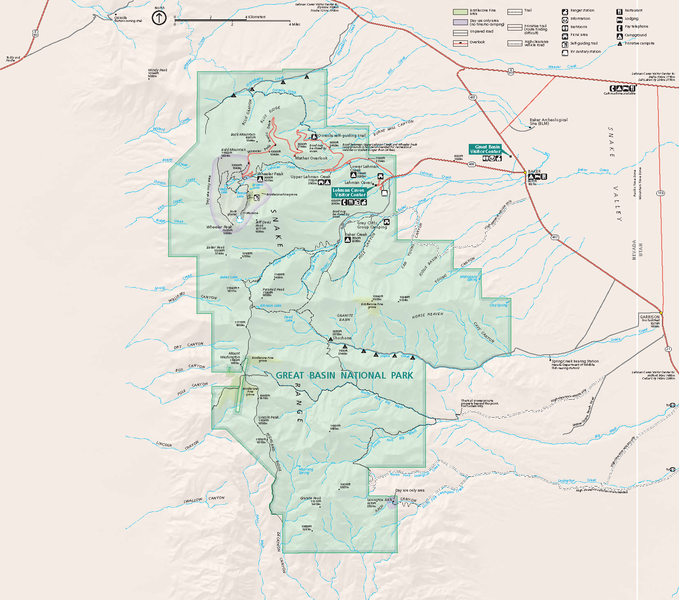
Official National Park Service map — of Great Basin National Park.
GRBAmap1.pdf |
| Datum | |
| Zdroj | [1] |
| Autor | National Park Service, Harpers Ferry Center |
| Svolení (Užití tohoto souboru) |
"The maps at this site are in the public domain. You may use National Park Service maps provided that you agree to assume complete legal responsibility for problems resulting from their use. Although National Park Service maps are easy to modify, understand that modifications can adversely alter the meaning and accuracy of the original data. Law prohibits you from using the National Park Service seal or claiming National Park Service endorsement with downloaded maps." [2] |
Licence
| This image or media file contains material based on a work of a National Park Service employee, created as part of that person's official duties. As a work of the U.S. federal government, such work is in the public domain in the United States. See the NPS website and NPS copyright policy for more information. |
Historie souboru
Kliknutím na datum a čas se zobrazí tehdejší verze souboru.
| Datum a čas | Náhled | Rozměry | Uživatel | Komentář | |
|---|---|---|---|---|---|
| současná | 14. 10. 2007, 06:48 | | 1 647 × 1 455 (649 KB) | Werewombat | == Summary == {{Information |Description = Official National Park Service map of en:Great Basin National Park, en:Nevada. Converted from PDF using Adobe Acrobat 7.0 Professional. O |
Využití souboru
Tento soubor používá následující stránka:
Globální využití souboru
Tento soubor využívají následující wiki:
- Využití na da.wikipedia.org
- Využití na fr.wikipedia.org
- Využití na he.wikipedia.org
- Využití na hu.wikipedia.org
- Využití na is.wikipedia.org
- Využití na nl.wikipedia.org
- Využití na pl.wikipedia.org
- Využití na ru.wikipedia.org
- Využití na tr.wikipedia.org