
Soubor:Glacial lakes, Bhutan.jpg

Původní soubor (3 000 × 1 665 pixelů, velikost souboru: 1,98 MB, MIME typ: image/jpeg)
| Tento soubor pochází z Wikimedia Commons. Níže jsou zobrazeny informace, které obsahuje jeho tamější stránka s popisem souboru. |
|

Tento soubor byl vybrán jako obrázek dne na 21. března 2007. Nadpis tohoto obrázku: Další jazyky:
Қазақша: Хималайя арқаларындағы мұздықтар мен көлдер, Бутан |
Popis
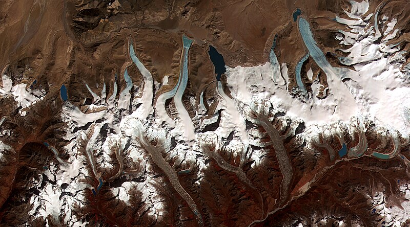
| Popis |
English: This image shows the termini of the glaciers in the Bhutan-Himalaya. Glacial lakes have been rapidly forming on the surface of the debris-covered glaciers in this region during the last few decades. USGS researchers have found a strong correlation between increasing temperatures and glacial retreat in this region. According to a joint press release issued by NASA and the U.S. Geological Survey, the great majority of the world’s glaciers appear to be declining at rates equal to or greater than long-established trends. This image from the ASTER (Advanced Spaceborne Thermal Emission and Reflection Radiometer) instrument aboard NASA’s Terra satellite shows the termini of the glaciers in the Bhutan-Himalaya. Glacial lakes have been rapidly forming on the surface of the debris-covered glaciers in this region during the last few decades. Français : Image de l'instrument ASTER (Advanced Spaceborne Thermal Emission and Reflection Radiometer) embarqué à bord du satellite Terra de la NASA montrant l'extrémité des glaciers hymalayens du Bhoutan.
Depuis quelques décennies, des lacs glaciaires se forment rapidement sur la surface couverte de débris de ces glaciers. Les scientifiques de l'USGS (United States Geological Survey) ont montré une forte corrélation entre la montée des températures et le retrait des glaciers dans la région. En Himalaya, les glaciers reculent a une vitesse alarmante et de plus en plus importante, ce qui est établi par la comparaison des données actuelles et historiques, ainsi que par la multiplication et la croissance rapide des lacs de surface de ces glaciers, selon Jeffrey Kargel, de l'USGS. |
|||||
| Datum | Data acquired on June 4, 2002, image released on June 8, 2006. | |||||
| Zdroj | http://visibleearth.nasa.gov/view_rec.php?id=2876 | |||||
| Autor | NASA | |||||
| Svolení (Užití tohoto souboru) |
|

| Pozice fotografa | | Tento snímek a mnohé další na: OpenStreetMap |
|---|
Historie souboru
Kliknutím na datum a čas se zobrazí tehdejší verze souboru.
| Datum a čas | Náhled | Rozměry | Uživatel | Komentář | |
|---|---|---|---|---|---|
| současná | 14. 2. 2006, 00:19 | | 3 000 × 1 665 (1,98 MB) | Brian0918 | larger version |
| 29. 10. 2005, 15:39 |  | 2 500 × 1 387 (1,68 MB) | Brian0918 | ||
| 26. 10. 2005, 18:34 |  | 2 000 × 1 110 (1,17 MB) | Brian0918 | Glacial lakes from retreating glaciers, Bhutan According to a joint press release issued by NASA and the U.S. Geological Survey, the great majority of the world’s glaciers appear to be declining at rates equal to or greater than long-established trends |
Využití souboru
Tento soubor používá následujících 5 stránek:
Globální využití souboru
Tento soubor využívají následující wiki:
- Využití na az.wikipedia.org
- Využití na ba.wikipedia.org
- Využití na bn.wikipedia.org
- Využití na bo.wikipedia.org
- Využití na bs.wikipedia.org
- Využití na ca.wikipedia.org
- Využití na ce.wikipedia.org
- Využití na da.wikipedia.org
- Využití na de.wikipedia.org
- Využití na el.wikipedia.org
- Využití na en.wikipedia.org
- Geography of Bhutan
- Glacial motion
- Wikipedia:Featured pictures thumbs/03
- Wikipedia:Featured picture candidates/Glacial lakes, Bhutan.jpg
- User:Axezz/Miscellaneous
- Wikipedia:Featured picture candidates/November-2005
- Wikipedia:Wikipedia Signpost/2005-11-14/Features and admins
- User talk:Brian0918/Archive 14
- Portal:Earth sciences
- User talk:Brian0918/Featured gallery
- User:Cyde/Featured pictures
- Wikipedia:Picture of the day/February 2006
- Wikipedia:Picture of the day/February 14, 2006
- Wikipedia:POTD/February 14, 2006
- Wikipedia:POTD column/February 14, 2006
- User talk:Brian0918/Archive 19
- Retreat of glaciers since 1850
- Portal:Geography/Featured picture/2006, week 27
- Wikipedia:WikiProject Glaciers
- Wikipedia:Featured pictures/Space/Looking back
- Portal:Geography/Featured picture archive/2006
- Glacier terminus
- Portal:Earth sciences/Selected pictures
- User:Danielhammocks
- User:Mytwocents/Globalnull Warmingnull
- Glaciers in Bhutan
- Lakes of Bhutan
- User:Skimble skamble
- Wikipedia:Wikipedia Signpost/Single/2005-11-14
- Využití na en.wikibooks.org
- Využití na en.wikinews.org
Zobrazit další globální využití tohoto souboru.