
Soubor:Franz Josef Land, Aug 2011.jpg
Původní soubor (2 400 × 1 800 pixelů, velikost souboru: 812 KB, MIME typ: image/jpeg)
| Tento soubor pochází z Wikimedia Commons. Níže jsou zobrazeny informace, které obsahuje jeho tamější stránka s popisem souboru. |
Popis
| Popis |
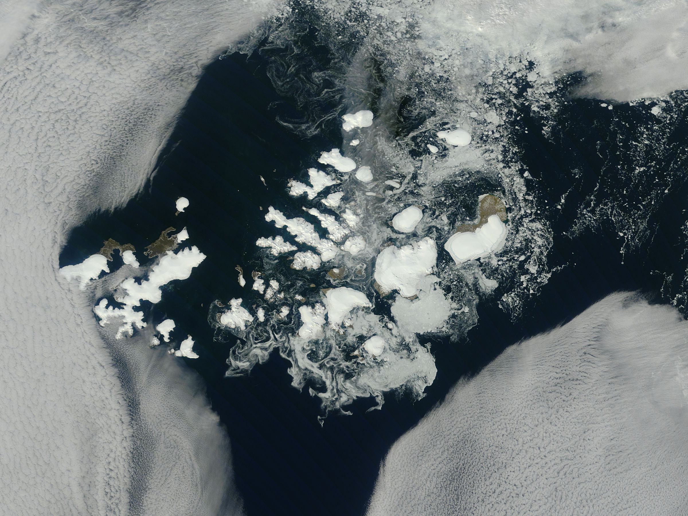
NASA image captured this true-color image on August 14, 2011 The clouds parted over the northeast Barents Sea region of the Arctic Ocean in late summer allowing a view of the ice-covered islands of Franz Josef Land (Russia) forming a stark-white contrast to the surrounding dark sea water. The Moderate Resolution Imaging Spectroradiometer (MODIS) aboard the Terra satellite captured this true-color image on August 14, 2011. Franz Josef Land is an archipelago of 6 main islands and about 135 small islands, with a total landmass of about 16,134 square kilometers (6,229 square miles). The terrain is primarily elevated table lands and low hills, with the highest point rising to 620 m (2034 feet). The glaciers on the islands of Franz Josef are currently in a state of retreat, and in this image large areas of the main islands clearly appear ice free. However, up to 85% of the island’s landmass is permanently ice-covered, with an average ice thickness of about 180 m (590 feet). On Graham Bell Island —the large island on the eastern edge of the group— the Windy Dome Ice Cap reaches a depth of greater than 500 m (1,640 feet). Although being late summer, sea ice can still be seen surrounding many of the islands. Credit: NASA/GSFC/Jeff Schmaltz/MODIS Land Rapid Response Team NASA Goddard Space Flight Center enables NASA’s mission through four scientific endeavors: Earth Science, Heliophysics, Solar System Exploration, and Astrophysics. Goddard plays a leading role in NASA’s accomplishments by contributing compelling scientific knowledge to advance the Agency’s mission. Follow us on Twitter Like us on Facebook Find us on Instagram |
| Datum | |
| Zdroj |
Franz Josef Land, Arctic Ocean
|
| Autor | NASA Goddard Space Flight Center from Greenbelt, MD, USA |
Licence
| This file is in the public domain in the United States because it was solely created by NASA. NASA copyright policy states that "NASA material is not protected by copyright unless noted". (See Template:PD-USGov, NASA copyright policy page or JPL Image Use Policy.) | ||
 |
Warnings:
|
- Dílo smíte:
- šířit – kopírovat, distribuovat a sdělovat veřejnosti
- upravovat – pozměňovat, doplňovat, využívat celé nebo částečně v jiných dílech
- Za těchto podmínek:
- uveďte autora – Máte povinnost uvést autorství, poskytnout odkaz na licenci a uvést, pokud jste provedli změny. Toho můžete docílit jakýmkoli rozumným způsobem, avšak ne způsobem naznačujícím, že by poskytovatel licence schvaloval nebo podporoval vás nebo vaše užití díla.
| Tento obrázek, který byl původně zveřejněn na Flickru, zkontroloval August 31, 2011 správce nebo kontrolor File Upload Bot (Magnus Manske) a potvrdil, že je na Flickru dostupný pod správnou licencí. |
Historie souboru
Kliknutím na datum a čas se zobrazí tehdejší verze souboru.
| Datum a čas | Náhled | Rozměry | Uživatel | Komentář | |
|---|---|---|---|---|---|
| současná | 31. 8. 2011, 23:04 | | 2 400 × 1 800 (812 KB) | File Upload Bot (Magnus Manske) | {{Information |Description=NASA image captured this true-color image on August 14, 2011 The clouds parted over the northeast Barents Sea region of the Arctic Ocean in late summer, 2011 allowing a view of the ice-covered islands of Franz Josef Land, Russi |
Využití souboru
Tento soubor používá následující stránka:
Globální využití souboru
Tento soubor využívají následující wiki:
- Využití na af.wikipedia.org
- Využití na ar.wikipedia.org
- Využití na avk.wikipedia.org
- Využití na az.wikipedia.org
- Využití na ba.wikipedia.org
- Využití na ca.wikipedia.org
- Využití na cv.wikipedia.org
- Využití na da.wikipedia.org
- Využití na de.wikipedia.org
- Využití na el.wikipedia.org
- Využití na en.wikipedia.org
- Využití na fr.wikipedia.org
- Využití na lt.wikipedia.org
- Využití na oc.wikipedia.org
- Využití na pl.wikipedia.org
- Využití na ru.wikipedia.org
- Využití na sco.wikipedia.org
- Využití na simple.wikipedia.org
- Využití na vi.wikipedia.org