
Soubor:Europe 814.svg

Původní soubor (soubor SVG, nominální rozměr: 1 399 × 919 pixelů, velikost souboru: 3,4 MB)
| Tento soubor pochází z Wikimedia Commons. Níže jsou zobrazeny informace, které obsahuje jeho tamější stránka s popisem souboru. |
Popis
| Popis |
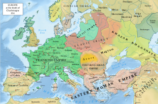
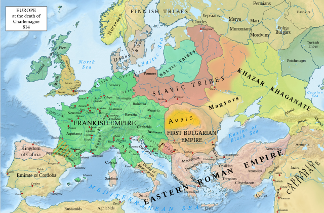
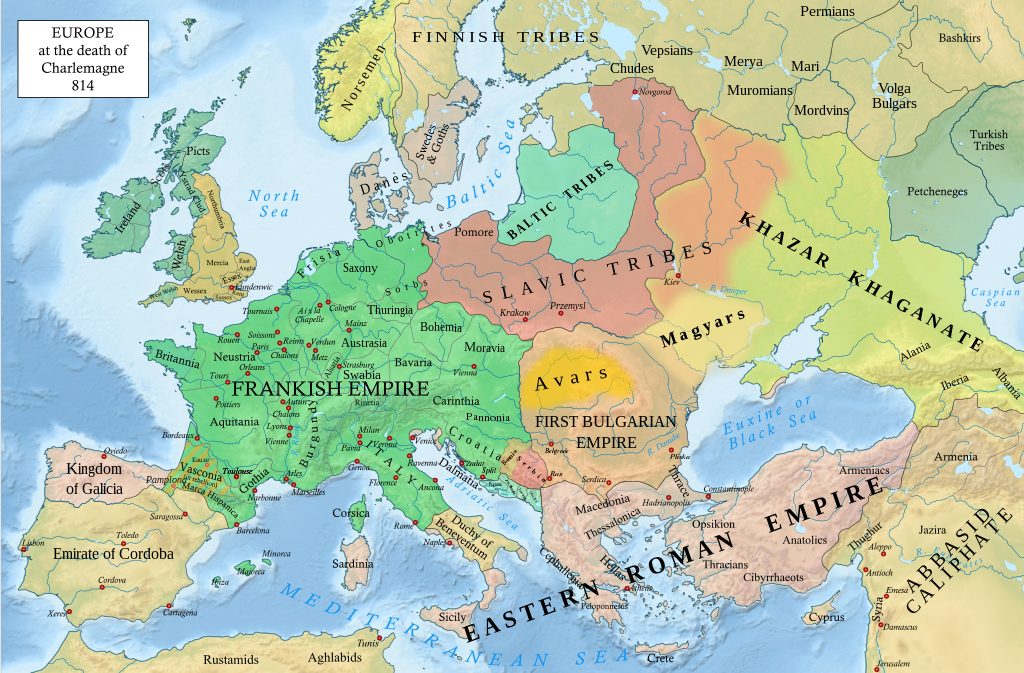
English: An svg version of File:Europe 814.jpg with corrections.
List of corrections:
|
| Datum | |
| Zdroj | "The Public Schools Historical Atlas" by Charles Colbeck. Longmans, Green; New York; London; Bombay. 1905. |
| Autor | Hel-hama |
| Další verze |
|


_en.png)
.png)
.jpg)
Licence
- Dílo smíte:
- šířit – kopírovat, distribuovat a sdělovat veřejnosti
- upravovat – pozměňovat, doplňovat, využívat celé nebo částečně v jiných dílech
- Za těchto podmínek:
- uveďte autora – Máte povinnost uvést autorství, poskytnout odkaz na licenci a uvést, pokud jste provedli změny. Toho můžete docílit jakýmkoli rozumným způsobem, avšak ne způsobem naznačujícím, že by poskytovatel licence schvaloval nebo podporoval vás nebo vaše užití díla.
- zachovejte licenci – Pokud tento materiál jakkoliv upravíte, přepracujete nebo použijete ve svém díle, musíte své příspěvky šířit pod stejnou nebo slučitelnou licencí jako originál.
Toto dílo je ve Spojených státech volným dílem. To platí pro americká díla, jejichž autorská práva vypršela, často proto, že byla poprvé zveřejněna před 1. lednem 1929. Podívejte se na tuto stránku pro další vysvětlení.
|
 | |
 |
Tento obrázek nemusí být volným dílem mimo Spojené státy; to se týká zvláště těch zemí a oblastí, kde pro americká díla neplatí pravidlo kratší doby, jako jsou Kanada, Kontinentální Čína (ne Hong Kong nebo Macao), Německo, Mexiko a Švýcarsko. Tvůrce a rok publikace jsou nezbytné informace a musí být uvedeny. Viz Wikipedie:Autorské právo pro více informací.
|
.svg)
|
This file is licensed under the Open Government Licence version 1.0 (OGL v1.0).
|
|---|---|
|
You are free to:
See the Open Government Licence page on Meta-Wiki for more information.
|
This work is in the public domain in India because its term of copyright has expired.
The Indian Copyright Act applies in India to works first published in India. According to the Indian Copyright Act, 1957, as amended up to Act No. 27 of 2012 (Chapter V, Section 25):
|
 |
Historie souboru
Kliknutím na datum a čas se zobrazí tehdejší verze souboru.
| Datum a čas | Náhled | Rozměry | Uživatel | Komentář | |
|---|---|---|---|---|---|
| současná | 8. 1. 2023, 22:05 | | 1 399 × 919 (3,4 MB) | Miki Filigranski | correction of Bosnian border, which was a separate land according to modern scholarship, contested but never completelly under Serbian or Croatian control |
| 29. 11. 2022, 23:32 |  | 1 399 × 919 (3,39 MB) | Gyalu22 | Added Avar ethnic territory, see Bulgarians_and_Slavs_VI-VII_century.png. Also extended Magyar ethnic territory to Bessarabia | |
| 1. 11. 2022, 12:26 |  | 1 399 × 919 (3,38 MB) | Miki Filigranski | Reverted to version as of 07:20, 31 July 2022 (UTC) | |
| 3. 8. 2022, 06:47 |  | 1 399 × 919 (3,38 MB) | Bernd21t | (shrnutí editace odstraněno) | |
| 31. 7. 2022, 09:20 |  | 1 399 × 919 (3,38 MB) | Miki Filigranski | Reverted to version as of 16:51, 27 March 2022 (UTC) | |
| 18. 7. 2022, 07:13 |  | 1 399 × 919 (3,38 MB) | Ionelen | Reverted to version as of 19:41, 13 April 2022 (UTC) | |
| 12. 7. 2022, 09:41 |  | 1 399 × 919 (3,38 MB) | Ahmet Q. | Reverted to version as of 16:51, 27 March 2022 (UTC) | |
| 13. 4. 2022, 21:41 |  | 1 399 × 919 (3,38 MB) | Wojsław12 | Reverted to version as of 11:43, 14 January 2022 (UTC) | |
| 27. 3. 2022, 18:51 |  | 1 399 × 919 (3,38 MB) | Silverije | Reverted to version as of 12:43, 1 June 2021 (UTC) | |
| 14. 1. 2022, 13:43 |  | 1 399 × 919 (3,38 MB) | TómasdeAquino2 | Corrected POV issues of blocked sock of Crovata Miki Filigranski |
Využití souboru
Tento soubor používají následující 4 stránky:
Globální využití souboru
Tento soubor využívají následující wiki:
- Využití na af.wikipedia.org
- Využití na ar.wikipedia.org
- Využití na arz.wikipedia.org
- Využití na bg.wikipedia.org
- Využití na bn.wikipedia.org
- Využití na ca.wikipedia.org
- Využití na cy.wikipedia.org
- Využití na de.wikipedia.org
- Využití na el.wikipedia.org
- Využití na en.wikipedia.org
- Charlemagne
- History of Europe
- Vikings
- 814
- History of Estonia
- Bulgars
- Principality of Serbia (early medieval)
- Saare County
- Early Middle Ages
- Kvenland
- Askold and Dir
- Duchy of Benevento
- Portal:Estonia
- Franks
- Višeslav of Serbia
- History of Christian thought on persecution and tolerance
- Borna (duke)
- Vlastimir
- Arab–Khazar wars
- Duchy of Gascony
- Muslim conquest of Sicily
- Prosigoj
- Rus' people
- Early Slavs
- Radoslav of Serbia
- Barbarian kingdoms
- Agriculture in the Middle Ages
- Gersuinda
- User:Falcaorib
- Využití na en.wikibooks.org
- Využití na en.wikiversity.org
- Využití na et.wikipedia.org
Zobrazit další globální využití tohoto souboru.