
Soubor:English kingdoms.svg

Velikost tohoto PNG náhledu tohoto SVG souboru: 481 × 599 pixelů. Jiná rozlišení: 192 × 240 pixelů | 385 × 480 pixelů | 616 × 768 pixelů | 822 × 1 024 pixelů | 1 643 × 2 048 pixelů | 678 × 845 pixelů.
Původní soubor (soubor SVG, nominální rozměr: 678 × 845 pixelů, velikost souboru: 434 KB)
| Tento soubor pochází z Wikimedia Commons. Níže jsou zobrazeny informace, které obsahuje jeho tamější stránka s popisem souboru. |
Popis
| Popis |
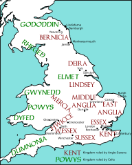
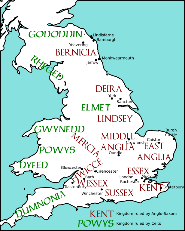
English: Map of England and Wales, showing Anglo-Saxon and Celtic kingdoms as of c. 600.
Redrawn from a map in James Campbell, The Anglo-Saxons, Penguin Books, 1991. |
||
| Datum | 26. června 2007 (datum prvotního načtení souboru) | ||
| Zdroj | The file was created using DMIS. On that site it is stated that "We do not claim copyright on the images, so you can use them for Wikipedia." | ||
| Autor | Mike Christie na projektu Wikipedie v jazyce angličtina | ||
| Svolení (Užití tohoto souboru) |
|
||
| Další verze | File:English kingdoms 600.png, File:English kingdoms 600.gif |
Původní historie souboru
Na Commons přenesl z en.wikipedia uživatel NuclearWarfare pomocí nástroje CommonsHelper.
Původní stránka s popisem souboru byla zde. Všechna následující uživatelská jména odkazují na projekt en.wikipedia.
- 2007-06-26 01:36 Mike Christie 651×897× (285282 bytes) Map of England and Wales, showing Anglo-Saxon and Celtic kingdoms as of c. 600. The file was created using [http://www.demis.nl/home/pages/home.htm DMIS]. On that site it is [http://support.demis.nl/forums/thread/1295.aspx stated] that "We do not claim
Licence
| Já, autor tohoto díla, jej tímto uvolňuji jako volné dílo, a to celosvětově. V některých zemích to není podle zákona možné; v takovém případě: Poskytuji komukoli právo užívat toto dílo za libovolným účelem, a to bezpodmínečně s výjimkou podmínek vyžadovaných zákonem. |
Historie souboru
Kliknutím na datum a čas se zobrazí tehdejší verze souboru.
| Datum a čas | Náhled | Rozměry | Uživatel | Komentář | |
|---|---|---|---|---|---|
| současná | 31. 12. 2010, 04:04 | | 678 × 845 (434 KB) | AnonMoos | margins, land should not be transparent |
| 27. 5. 2010, 00:39 |  | 689 × 905 (441 KB) | Marnanel | {{Information |Description={{en|1={{svg|map}} {{Information |Description={{en|Map of England and Wales, showing Anglo-Saxon and Celtic kingdoms as of c. 600. Redrawn from a map in James Campbell, ''The Anglo-Saxons'', Penguin Books, 1991.}} |Source=Tran |
Využití souboru
Tento soubor používají následující 2 stránky:
Globální využití souboru
Tento soubor využívají následující wiki:
- Využití na de.wikipedia.org
- Využití na en.wikipedia.org
- Využití na it.wikipedia.org
- Discussione:Adda di Bernicia
- Discussione:Aethelric di Bernicia
- Discussione:Glappa di Bernicia
- Discussione:Cearl di Mercia
- Discussione:Ceawlin dei Gewisse
- Discussione:Ceol dei Gewisse
- Discussione:Ceolwulf dei Gewisse
- Discussione:Eowa
- Discussione:Etelrico di Deira
- Discussione:Hussa di Bernicia
- Discussione:Theodric di Bernicia
- Využití na nl.wikipedia.org
- Využití na pl.wikipedia.org