
Soubor:Empire of the Kökturks.png

Velikost tohoto náhledu: 800 × 499 pixelů. Jiná rozlišení: 320 × 200 pixelů | 640 × 399 pixelů | 1 024 × 638 pixelů | 1 280 × 798 pixelů | 1 745 × 1 088 pixelů.
Původní soubor (1 745 × 1 088 pixelů, velikost souboru: 2,56 MB, MIME typ: image/png)
| Tento soubor pochází z Wikimedia Commons. Níže jsou zobrazeny informace, které obsahuje jeho tamější stránka s popisem souboru. |
Popis
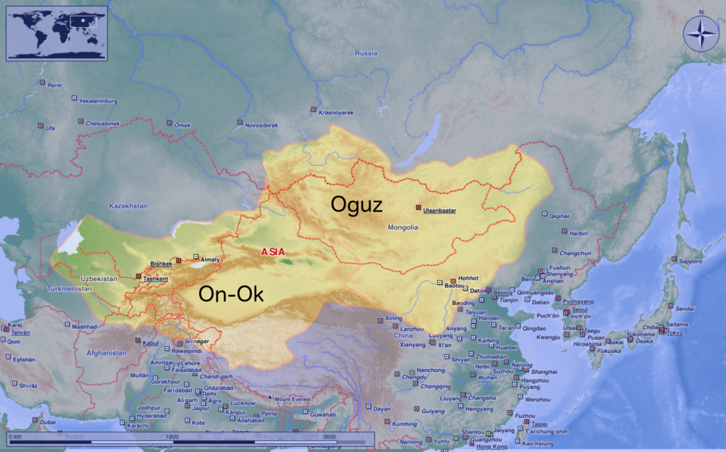
| Popis | This map shows the kingdom of Kökturks after the division of the kingdom in 552. The grey area shows the area of On-Ok or the western Kökturks. The white area shows the area of the eastern Kökturk. This area was still in the sixth Century a Chinese protectorate. 745 the Kökturks were part of the Uyghur empire. After 840 Kökturks and the Uyghurs were conquered by the Kyrgyz. The source of this map: "Der große Atlas Weltgeschichte", Orbis Verlag 1990, ISBN 3-572-04755-2, P. 47 & 51 |
| Datum | |
| Zdroj | Vlastní dílo |
| Autor | Hardcore-Mike |
Licence
Já, držitel autorských práv k tomuto dílu, ho tímto zveřejňuji za podmínek následující licence:
Tento soubor podléhá licenci Creative Commons Uveďte autora 3.0 Unported
- Dílo smíte:
- šířit – kopírovat, distribuovat a sdělovat veřejnosti
- upravovat – pozměňovat, doplňovat, využívat celé nebo částečně v jiných dílech
- Za těchto podmínek:
- uveďte autora – Máte povinnost uvést autorství, poskytnout odkaz na licenci a uvést, pokud jste provedli změny. Toho můžete docílit jakýmkoli rozumným způsobem, avšak ne způsobem naznačujícím, že by poskytovatel licence schvaloval nebo podporoval vás nebo vaše užití díla.
Historie souboru
Kliknutím na datum a čas se zobrazí tehdejší verze souboru.
| Datum a čas | Náhled | Rozměry | Uživatel | Komentář | |
|---|---|---|---|---|---|
| současná | 10. 8. 2020, 12:16 | | 1 745 × 1 088 (2,56 MB) | MicBy67 | Leichte Überarbeitung der Grenzverläufe, Änderung des westl. Teilreiches in "On-Ok" |
| 26. 7. 2020, 02:48 |  | 1 745 × 1 088 (2,56 MB) | MicBy67 | Überarbeitung | |
| 1. 11. 2012, 21:59 |  | 1 056 × 850 (1,17 MB) | MicBy67 | Map fault repaired | |
| 1. 11. 2012, 20:17 |  | 1 056 × 850 (1,17 MB) | MicBy67 | {{Information |Description=This map shows the kingdom of Kökturks after the division of the kingdom in 552. The grey area shows the area of On-Ok or the western Kökturks. The white area shows the area of the eastern Kökturk. This area was still in t... |
Využití souboru
Tento soubor používá následující stránka:
Globální využití souboru
Tento soubor využívají následující wiki:
- Využití na ast.wikipedia.org
- Využití na de.wikipedia.org
- Využití na en.wikipedia.org
- Využití na es.wikipedia.org
- Využití na fr.wikipedia.org
- Využití na mn.wikipedia.org
- Využití na pnb.wikipedia.org
- Využití na sl.wikipedia.org
- Využití na zh.wikipedia.org