
Soubor:El Vizcaíno Biosphere Reserve Landsat picture annotated.jpg
Původní soubor (720 × 720 pixelů, velikost souboru: 184 KB, MIME typ: image/jpeg)
| Tento soubor pochází z Wikimedia Commons. Níže jsou zobrazeny informace, které obsahuje jeho tamější stránka s popisem souboru. |
Popis
| Popis |
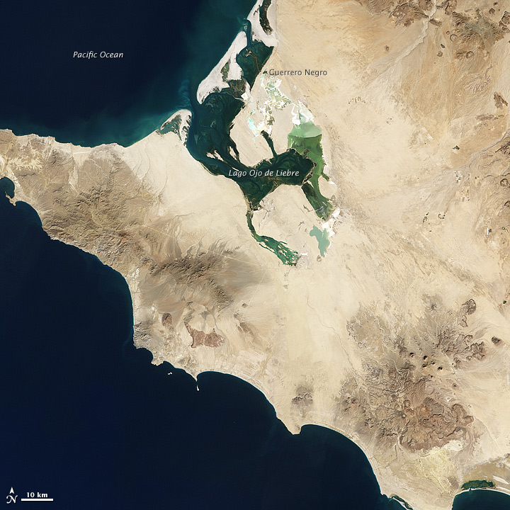
English: El Vizcaíno Biosphere Reserve — located midway down the Baja California Peninsula, in the Mulegé Municipality, northern Baja California Sur state, northwestern México.
Deutsch: Etwa in der Mitte der Halbinsel Niederkalifornien liegt ein Naturreservat, das die United Nations Educational, Scientific, and Cultural Organization (UNESCO) zu einer Welterbestätte erklärt hat. Es umfaßt zwei Lagunen und einen großen Landstreifen dazwischen. Das El-Vizcaíno-Biosphärenreservat ist eine Überwinterungsstätte für Grauwale und andere Meeressäugetiere und Habitat für tausende von Wasserzugvögeln. Zur Vegetation in dem Reservat gehören die für die Sonora typische Wüstenvegetation und, am Uferstreifen, Mangroven.
Am 5. Dezember 2002 hat der Enhanced Thematic Mapper Plus an Bord des Satelliten Landsat 7 dieses Bild vom westlichen Teil des Reservats aufgenommen, einschließlich des Lago Ojo de Liebre. In den westlichen Ausläufern von El Vizcaíno liegt das Gelände nur wenig über dem Meeresspiegel, und das Land ist trocken. Die jährliche Niederschlagsmenge liegt im allgemeinen unter 80 Millimetern, und Wasser verdunstet hier so rasch, dass die Fließgewässer kaum die Küste erreichen. Gleichzeitig häufen andauernde Winde losen Sand zu Dünen auf. Doch ist das Land nicht vollständig der Dürre ausgesetzt; mehr als 400 Pflanzenspezies wurden in dem Biosphärenreservat gezählt, viele von ihnen Gestrüpp oder Krautpflanzen. Das Gestein in dieser Region entstand weitgehend durch Sedimentierung von Material, das durh Wind oder Wasser erodiert worden war und an anderer Stelle abgelagert wurde. Vulkanisches Gestein ist zwischen den Sedimentschichten verschiedentlich anstehend und kann durch seine dunklere Farbe und die stäarker zerklüftete Oberfläche. Eine Ansammlung vulkanischen Gesteins ist auf dem Bild südöstlich des Lago Ojo de Liebre sichtbar. Dieses Bild zeigt auch Spuren menschlicher Aktivität. So stammen einige der am deutlichsten grünen Gebiete nicht von üppiger Vegetation sondern von der Salzgewinnung. Entlang der Ufer des Lago Ojo de Liebre und in der Nähe der Stadt Guerrero Negro erzeugt ein Salzwerk jährlich etwa sieben Millionen Tonnen Salz. Die Salzgärten kontrastieren durch ihre regelmäßigen rechteckigen Formen und grüne Färbung mit der Umgebung. |
| Datum | |
| Zdroj | http://earthobservatory.nasa.gov/IOTD/view.php?id=77499 |
| Autor | NASA Earth Observatory image by Jesse Allen and Robert Simmon, using Landsat data from the United States Geological Survey. Caption by Michon Scott. |
| Další verze | File:El Vizcaíno Biosphere Reserve Landsat picture big.jpg |
Licence
| This file is in the public domain in the United States because it was solely created by NASA. NASA copyright policy states that "NASA material is not protected by copyright unless noted". (See Template:PD-USGov, NASA copyright policy page or JPL Image Use Policy.) | ||
 |
Warnings:
|
Historie souboru
Kliknutím na datum a čas se zobrazí tehdejší verze souboru.
| Datum a čas | Náhled | Rozměry | Uživatel | Komentář | |
|---|---|---|---|---|---|
| současná | 25. 3. 2012, 22:31 | | 720 × 720 (184 KB) | Matthiasb | {{Information |Description ={{en|1=Midway down the Baja California Peninsula lies a wildlife reserve that the United Nations Educational, Scientific, and Cultural Organization (UNESCO) has declared a World Heritage site. Encompassing two lagoons and... |
Využití souboru
Tento soubor používá následující stránka:
Globální využití souboru
Tento soubor využívají následující wiki:
- Využití na de.wikipedia.org
- Využití na en.wikipedia.org
- Využití na he.wikipedia.org
- Využití na hr.wikipedia.org
- Využití na mk.wikipedia.org
- Využití na mt.wikipedia.org
- Využití na sk.wikipedia.org
- Využití na vec.wikipedia.org
- Využití na zh.wikipedia.org