
Soubor:Duchy of Wesphalia and other states, circa 1645.svg

Velikost tohoto PNG náhledu tohoto SVG souboru: 800 × 516 pixelů. Jiná rozlišení: 320 × 206 pixelů | 640 × 413 pixelů | 1 024 × 660 pixelů | 1 280 × 826 pixelů | 2 560 × 1 651 pixelů.
Původní soubor (soubor SVG, nominální rozměr: 800 × 516 pixelů, velikost souboru: 176 KB)
| Tento soubor pochází z Wikimedia Commons. Níže jsou zobrazeny informace, které obsahuje jeho tamější stránka s popisem souboru. |
Popis
| Popis |
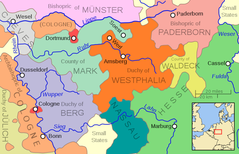
English: A map showing the Duchy of Westphalia and other eastern German states in the year 1645. Cologne and Dortmund were w:en:Free Imperial Cities. The various small Nassau and Hessian states are not shown separately. The smaller states are also not differentiated, but rather are shown in a light cream color. |
| Datum | |
| Zdroj | Vlastní dílo |
| Autor | MapMaster |
| Další verze | Díla odvozená od tohoto souboru: Herzogtum Westfalen und Umland etwa 1645.svg |
References
This map was built using Roke Astrokey's excellent map File:Holy Roman Empire 1648.svg. This basic outline was modified using information from the Willem Janszoon and Joan Blaeu maps of 1645 as well as:
- "L'area' tedesca nel 1648" (1999) Atlante Storico Agostini, p. 107, ISBN 8841566841.
Licence
Já, držitel autorských práv k tomuto dílu, ho tímto zveřejňuji za podmínek následující licence:
Tento soubor podléhá licenci Creative Commons Uveďte autora 3.0 Unported
- Dílo smíte:
- šířit – kopírovat, distribuovat a sdělovat veřejnosti
- upravovat – pozměňovat, doplňovat, využívat celé nebo částečně v jiných dílech
- Za těchto podmínek:
- uveďte autora – Máte povinnost uvést autorství, poskytnout odkaz na licenci a uvést, pokud jste provedli změny. Toho můžete docílit jakýmkoli rozumným způsobem, avšak ne způsobem naznačujícím, že by poskytovatel licence schvaloval nebo podporoval vás nebo vaše užití díla.
Historie souboru
Kliknutím na datum a čas se zobrazí tehdejší verze souboru.
| Datum a čas | Náhled | Rozměry | Uživatel | Komentář | |
|---|---|---|---|---|---|
| současná | 6. 5. 2011, 15:44 | | 800 × 516 (176 KB) | Ras67 | valid svg code |
| 6. 5. 2011, 05:45 |  | 800 × 516 (144 KB) | Ras67 | frame removed, 800px | |
| 16. 10. 2009, 06:03 |  | 704 × 459 (216 KB) | MapMaster | Needed to change page size to properly reflect enlarged drawing | |
| 15. 10. 2009, 23:48 |  | 352 × 229 (216 KB) | MapMaster | More river names, strict font usage, twice as large. | |
| 15. 10. 2009, 19:42 |  | 352 × 229 (208 KB) | MapMaster | {{Information |Description={{en|1=A map showing the Duchy of Westphalia and other eastern German states in the year 1645.}} |Source=Own work |Author=MapMaster |Date=15 October 2009 |Permission= |other_versions= }} [[Category:Maps of th |
Využití souboru
Tento soubor používá následující stránka:
Globální využití souboru
Tento soubor využívají následující wiki:
- Využití na bg.wikipedia.org
- Využití na es.wikipedia.org
- Využití na et.wikipedia.org
- Využití na fr.wikipedia.org
- Využití na it.wikipedia.org
- Využití na ja.wikipedia.org
- Využití na ru.wikipedia.org