
Soubor:Concord Retreat.png
Velikost tohoto náhledu: 800 × 342 pixelů. Jiná rozlišení: 320 × 137 pixelů | 640 × 273 pixelů | 1 024 × 437 pixelů | 1 280 × 546 pixelů | 3 235 × 1 381 pixelů.
Původní soubor (3 235 × 1 381 pixelů, velikost souboru: 780 KB, MIME typ: image/png)
| Tento soubor pochází z Wikimedia Commons. Níže jsou zobrazeny informace, které obsahuje jeho tamější stránka s popisem souboru. |
Popis
| Popis |
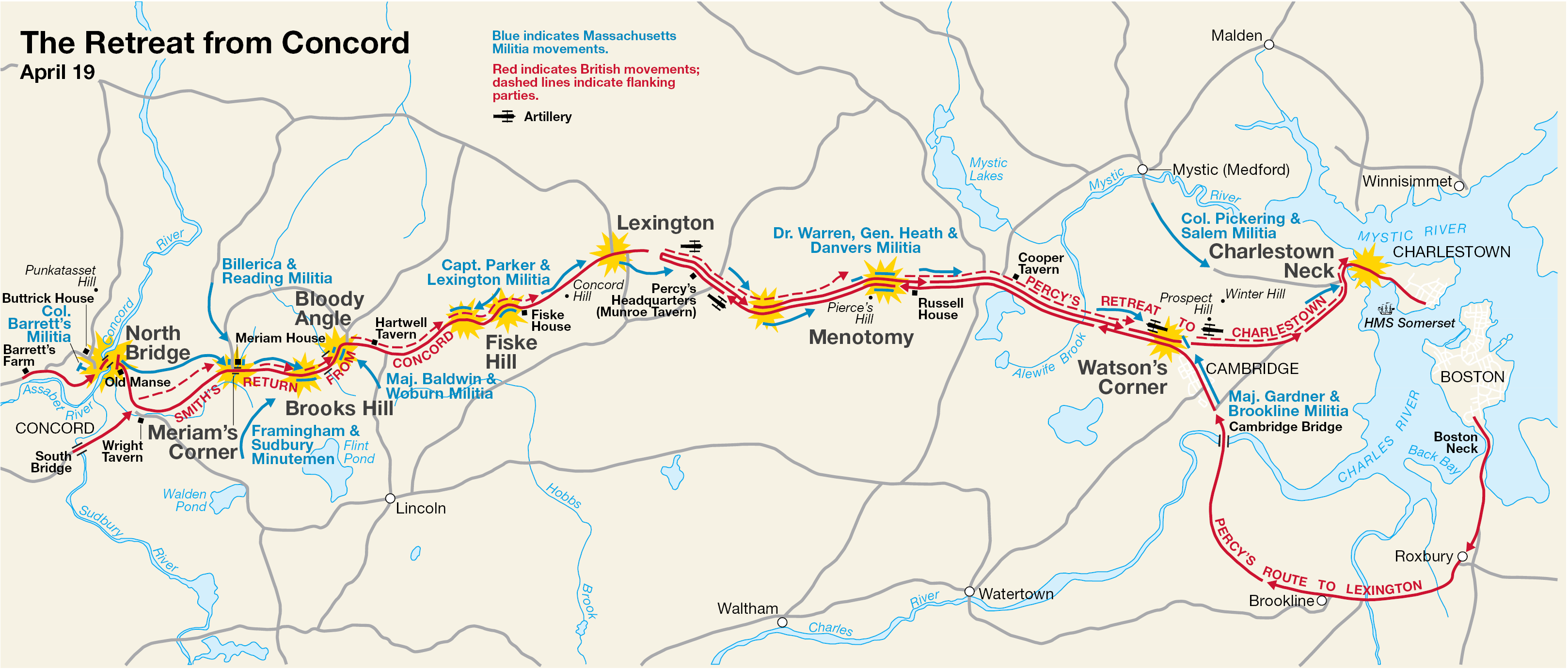
English: This is a map showing the route of the British army's 18-mile retreat from Concord to Charlestown in the Battles of Lexington and Concord on April 19, 1775. It shows the major points of conflict, as well as showing the route taken by Hugh, Earl Percy's reinforcements. |
| Datum | neznámé datum; source PDF created in 2000 |
| Zdroj | http://data2.itc.nps.gov/parks/mima/ppMaps/MIMAmap2.pdf |
| Autor | National Park Service |
| Další verze |
|

Licence
| This image or media file contains material based on a work of a National Park Service employee, created as part of that person's official duties. As a work of the U.S. federal government, such work is in the public domain in the United States. See the NPS website and NPS copyright policy for more information. |
Původní historie souboru
Na Commons přenesl z en.wikipedia uživatel Andrei Stroe pomocí nástroje CommonsHelper.
Původní stránka s popisem souboru byla zde. Všechna následující uživatelská jména odkazují na projekt en.wikipedia.
- 2006-11-30 17:35 Irayo 3235×1381× (799048 bytes) The Retreat from Concord April 19 (1775) Minute Man National Historical Park Battle Map http://data2.itc.nps.gov/parks/mima/ppMaps/MIMAmap2.pdf {{PD-USGov-Interior-NPS}}
Historie souboru
Kliknutím na datum a čas se zobrazí tehdejší verze souboru.
| Datum a čas | Náhled | Rozměry | Uživatel | Komentář | |
|---|---|---|---|---|---|
| současná | 29. 11. 2010, 21:11 | | 3 235 × 1 381 (780 KB) | File Upload Bot (Magnus Manske) | {{BotMoveToCommons|en.wikipedia|year={{subst:CURRENTYEAR}}|month={{subst:CURRENTMONTHNAME}}|day={{subst:CURRENTDAY}}}} {{Information |Description={{en|This is a map showing the route of the British army's 18-mile retreat from [[:en:Concord, Massachusetts |
Využití souboru
Tento soubor používá následující stránka:
Globální využití souboru
Tento soubor využívají následující wiki:
- Využití na ar.wikipedia.org
- Využití na azb.wikipedia.org
- Využití na en.wikipedia.org
- Využití na es.wikipedia.org
- Využití na fr.wikipedia.org
- Využití na it.wikipedia.org
- Využití na ro.wikipedia.org
- Využití na ru.wikipedia.org
- Využití na th.wikipedia.org
- Využití na zh.wikipedia.org