Soubor:Breakup of Yugoslavia.gif
Obsah stránky není podporován v jiných jazycích.
Z Wikipedie, otevřené encyklopedie

Původní soubor(1 545 × 1 242 pixelů, velikost souboru: 187 KB, MIME typ: image/gif, ve smyčce, 14 snímků, 44 s)

This image could be re-created using vector graphics as an SVG file. This has several advantages; see Commons:Media for cleanup for more information. If an SVG form of this image is available, please upload it and afterwards replace this template with {{vector version available|new image name}}. It is recommended to name the SVG file "Breakup of Yugoslavia.svg" - then the template Vector version available (or Vva) does not need the new image name parameter.

Popis

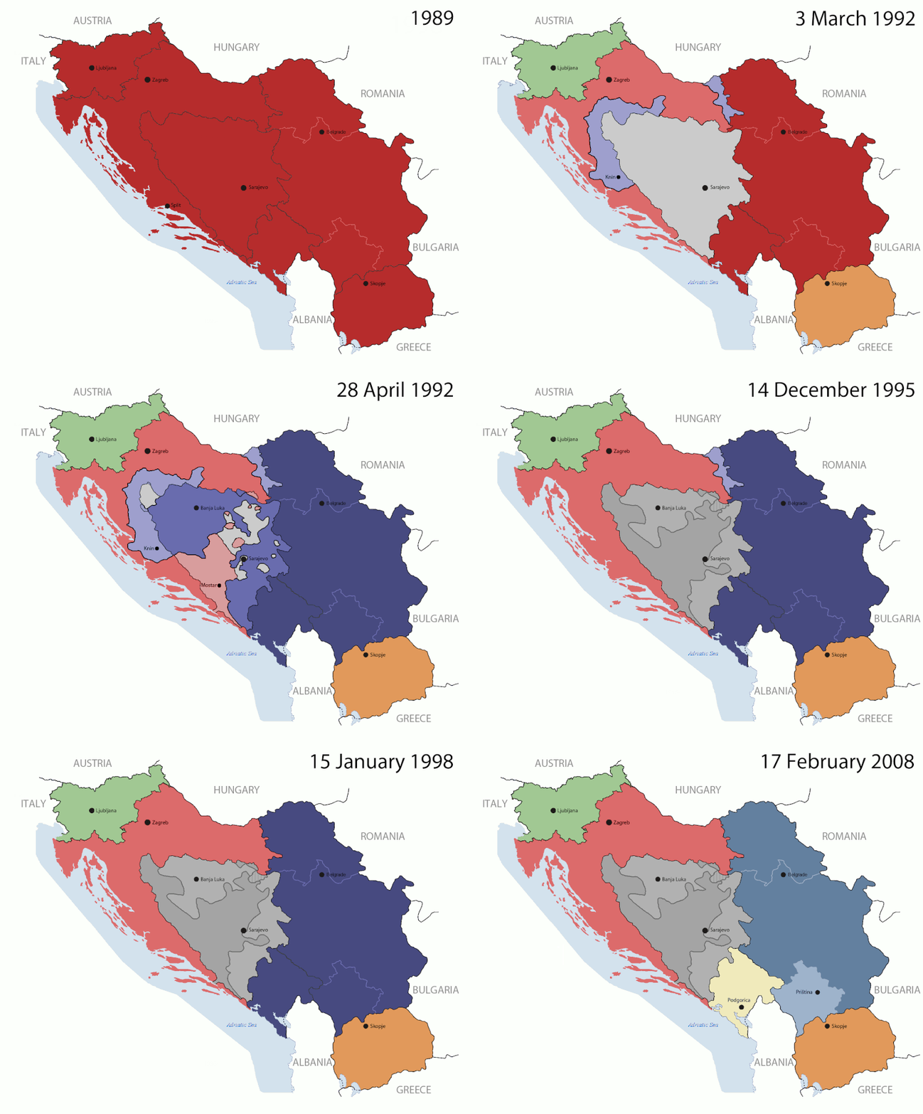
Key:

Yugoslavia (1943–1992) SFR Yugoslavia
Croatia (1991–present) Croatia
Herzeg-Bosnia (1992–1994)
UNTAES (1996–1998)
Federal Republic of Yugoslavia / Serbia and Montenegro (1992–2006) Serbia and Montenegro
Republika Srpska (1992–present) Republika Srpska
Serbian Krajina (1991–1995/96)
Republic of Bosnia and Herzegovina (1992–1995)
Bosnia and Herzegovina (1998–present) Bosnia and Herzegovina
Western Bosnia (1993–1995)
Serbia (2006–present) Serbia
Kosovo (under UNMIK control 1999–present; declaration of independence 2008) Kosovo
Montenegro (2006–present) Montenegro
Macedonia (1991–present) Macedonia
Slovenia (1991–present) Slovenia


Popis

This is an animated GIF that shows the stages of the breakup of the SFR Yugoslavia in the 90's and 2000's. The map based off Morwen's map of the divisions of the SFRY, Which is licensed by the GFDL. The source for the dates of independence is the CIA World Factbook. These maps do not now show the Inter-Entity Boundary Line (IEBL) and/or the entities that are separated by it. The IEBL has been drawn based on this CIA map; the Brčko District has been drawn based on Image:BH municipality location.gif, by user:Ante Perkovic. I might add them in the future.

Since the original map was GFDL, this image is as well.

A map depicting Kosovo's final status is ready once it takes effect.


Changelog for versions 2/3:

Here are some changes in this new build of the map:

  • The Kosovo boundary has been given a shade of red instead of the previous UN blue since they are a province of Serbia under UNIMIK control.
  • Montenegro's color has been changed to a golden shade close to what's on the flag.
  • The IEBL and the Brčko District has been redrawn because I deleted the original map; the color for the Republika Srpska is lighter.
  • The dates are at the top left hand corner of the map instead of the bottom.
  • I have taken a new approach as to the boundaries. Each part of Yugoslavia now shows the boundary on the maps starting the year they broke away. I feel this change helps readers understand the breakup better.
  • The SFRY and the FRY are in different shades since the FRY was never accepted as the successor to the former by the UN.
  • The colors for the entities of BiH have been removed as to not confuse people into thinking that they are independent states. What remains is the IEBL with both entities in green.
  • The Kosovo boundary is finally in hash marks!
  • The Brčko District has been removed. The sale is too small to show accurately.

Changelog for version 4:

  • The map is larger!
  • The image has been rebuilt to include the eastern part of FYR Macedonia.
  • The image has been updated to take in Kosovo's new status.
  • The IEBL is now a darker line.
  • Montenegro, Kosovo, and FRY/SCG/Serbia have new colors!

Changelog for version 5:

  • Rebuilt
  • Larger map: size of base image
  • Accurate Inter-Entity Boundary Line
Datum 24 July 2006 (orginal upload date)
Zdroj Made by Hoshie; see above for more details on sources.
Autor Hoshie
Další verze

Licence

GNU head Tento dokument smí být kopírován, šířen nebo upravován podle podmínek Svobodné licence GNU pro dokumenty verze 1.2 nebo libovolné vyšší verze publikované nadací Free Software Foundation. Dokument nemá neměnné části ani texty na předním či zadním přebalu. Kopie textu licence je k dispozici v oddíle nazvaném GNU Free Documentation License.
w:cs:Creative Commons
uveďte autora zachovejte licenci
Tento soubor podléhá licenci Creative Commons Uveďte autora-Zachovejte licenci 3.0 Unported
Dílo smíte:
  • šířit – kopírovat, distribuovat a sdělovat veřejnosti
  • upravovat – pozměňovat, doplňovat, využívat celé nebo částečně v jiných dílech
Za těchto podmínek:
  • uveďte autora – Máte povinnost uvést autorství, poskytnout odkaz na licenci a uvést, pokud jste provedli změny. Toho můžete docílit jakýmkoli rozumným způsobem, avšak ne způsobem naznačujícím, že by poskytovatel licence schvaloval nebo podporoval vás nebo vaše užití díla.
  • zachovejte licenci – Pokud tento materiál jakkoliv upravíte, přepracujete nebo použijete ve svém díle, musíte své příspěvky šířit pod stejnou nebo slučitelnou licencí jako originál.
Tato licenční šablona byla k tomuto souboru přidána v rámci změny licencování.

Popisky

Přidejte jednořádkové vysvětlení, co tento soubor představuje

Položky vyobrazené v tomto souboru

zobrazuje

05ca2aefea8406b809968643552d5095c847a42f

191 625 bajt

44 sekunda

1 242 pixel

1 545 pixel

Historie souboru

Kliknutím na datum a čas se zobrazí tehdejší verze souboru.

(nejnovější | nejstarší) Ukázat (10 novějších | ) (10 | 20 | 50 | 100 | 250 | 500).
Datum a časNáhledRozměryUživatelKomentář
současná17. 7. 2016, 09:40Náhled verze z 17. 7. 2016, 09:401 545 × 1 242 (187 KB)מפתח-רשימהReverted to version as of 17:22, 21 August 2015 (UTC)
21. 8. 2015, 19:22Náhled verze z 21. 8. 2015, 19:221 463 × 1 158 (1,81 MB)BraganzaReverted to version as of 03:57, 19 January 2010
21. 8. 2015, 19:22Náhled verze z 21. 8. 2015, 19:221 545 × 1 242 (187 KB)BraganzaReverted to version as of 01:02, 19 December 2011
21. 8. 2015, 19:15Náhled verze z 21. 8. 2015, 19:15120 × 95 (3 KB)Braganza03:57, 19. Jan. 2010
19. 12. 2011, 03:02Náhled verze z 19. 12. 2011, 03:021 545 × 1 242 (187 KB)DIREKTORAdded details
27. 7. 2011, 20:09Náhled verze z 27. 7. 2011, 20:091 545 × 1 242 (170 KB)DIREKTORSmall fixes
27. 7. 2011, 19:28Náhled verze z 27. 7. 2011, 19:281 545 × 1 242 (171 KB)DIREKTORAdded UNMIK
27. 7. 2011, 18:38Náhled verze z 27. 7. 2011, 18:381 545 × 1 242 (165 KB)DIREKTORDates for the last two frames.
27. 7. 2011, 14:10Náhled verze z 27. 7. 2011, 14:101 545 × 1 242 (149 KB)DIREKTORLighter shade for country names
26. 7. 2011, 18:59Náhled verze z 26. 7. 2011, 18:591 545 × 1 242 (170 KB)DIREKTORHigher res plus details
(nejnovější | nejstarší) Ukázat (10 novějších | ) (10 | 20 | 50 | 100 | 250 | 500).

Tento soubor používají následující 3 stránky:

Globální využití souboru

Tento soubor využívají následující wiki:

Zobrazit další globální využití tohoto souboru.

Metadata