Soubor:Brandberg Massif Landsat Image.jpg

Obsah stránky není podporován v jiných jazycích.
Z Wikipedie, otevřené encyklopedie

Původní soubor(1 000 × 1 000 pixelů, velikost souboru: 215 KB, MIME typ: image/jpeg)

Popis

Popis
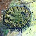
English: Satellite image of the Brandberg Massif, Namibia. Original figure caption: “Brandberg Massif is a dome-shaped granite intrusion that covers 250 square miles (650 square kilometers) and rises 1.6 miles (2,573 meters) above its surroundings in the central Namib Desert. Brandberg Massif is an important habitat for high-altitude savannah species and is of great archaeological interest due to the many prehistoric cave paintings found among its granite cliffs.
Deutsch: Satellitenbild des Brandberg Massivs, Namibia. Original Bildbeschriftung (modifizierte Übersetzung): Das Brandbergmassiv ist eine kuppelförmige Granit-Intrusion, deren Ausbiss sich über 650 Quadratkilometer erstreckt und sich 2.573 Meter über sein Umland in der zentralen Namib-Wüste erhebt. Das Brandberg-Massiv ist ein wichtiger Lebensraum für Pflanzen- und Tierarten der Hochlandsavanne und von hohem archäologischem Interesse aufgrund der zahlreichen frühgeschichtlichen Höhlenmalereien in seinen Granitklippen.
Datum 10. září 2002 (“acquisition date”)
Zdroj http://landsat.usgs.gov/images/gallery/26_L.jpg
Autor USGS

Licence

Public domain
Tento soubor je volné dílo, protože obsahuje materiály pocházející od United States Geological Survey (USGS), agentury Ministerstva vnitra USA. Pro bližší informaci vizte oficiální licenční pravidla USGS (anglicky).

Bahasa Indonesia  català  čeština  Deutsch  eesti  English  español  français  galego  italiano  Nederlands  português  polski  sicilianu  suomi  Tiếng Việt  Türkçe  български  македонски  русский  മലയാളം  한국어  日本語  中文  中文(简体)  中文(繁體)  العربية  فارسی  +/−

Popisky

Přidejte jednořádkové vysvětlení, co tento soubor představuje

Položky vyobrazené v tomto souboru

zobrazuje

14cdf2233bc91a9172ec853bb25bd2890573a295

220 169 bajt

1 000 pixel

1 000 pixel

Historie souboru

Kliknutím na datum a čas se zobrazí tehdejší verze souboru.

Datum a časNáhledRozměryUživatelKomentář
současná24. 8. 2005, 01:41Náhled verze z 24. 8. 2005, 01:411 000 × 1 000 (215 KB)Atamari{{PD-USGov-USGS}} * Brandberg Massif, Namibia * Acquisition Date:Sep 10,2002 * source http://landsat.usgs.gov/gallery/detail/367/ category:Namibia

Tento soubor používá následující stránka:

Globální využití souboru

Tento soubor využívají následující wiki:

Metadata