
Soubor:Austria satellite Grosslandschaften markerstyle.png
Velikost tohoto náhledu: 800 × 429 pixelů. Jiná rozlišení: 320 × 172 pixelů | 640 × 343 pixelů | 1 024 × 549 pixelů | 1 280 × 687 pixelů | 2 457 × 1 318 pixelů.
Původní soubor (2 457 × 1 318 pixelů, velikost souboru: 6,11 MB, MIME typ: image/png)
| Tento soubor pochází z Wikimedia Commons. Níže jsou zobrazeny informace, které obsahuje jeho tamější stránka s popisem souboru. |
| Popis |
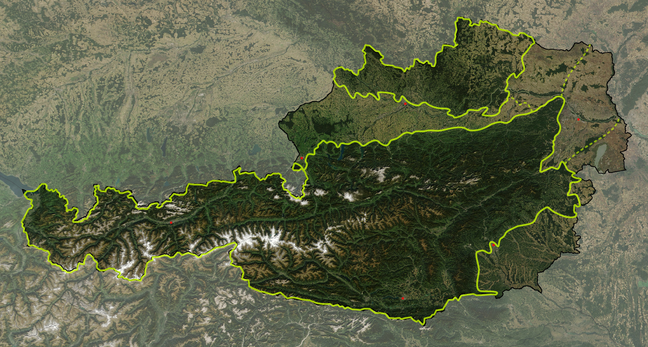
Deutsch: Satellitenbild von Österreich, mit den Großlandschaften: Österreichische Alpen, Vorländer und randalpine Becken, Granit- und Gneishochland
English: Satellite image of Austria with greater landscapes: Austrian Alps, Alpine Forelands and Rim Basins, Granite and Gneiss Highlands |
||
| Datum | |||
| Zdroj | The image is based on a satellite image from [1]. Original image: Credit Jeff Schmaltz, MODIS Rapid Response Team, NASA/GSFC. It was cropped and reduced in contrast around Austria by Michael Schmid, which is Image:Austria satellite unannotated.jpg. Borderlines added with Inkscape. | ||
| Autor | W!B: | ||
| Svolení (Užití tohoto souboru) |
Based on a NASA image, thus in the public domain. | ||
| PNG vývoj |
|
![[1]](http://visibleearth.nasa.gov/images/5947/Italy.A2003262.1005.250m.jpg)
The borders of Austrian greater landscapes are derived from:
- Alps:
- W. Kilian, F. Müller, F. Starlinger: Die forstlichen Wuchsgebiete Österreichs. Eine Naturraumgliederung nach waldökologischen Gesichtspunkten. Forstliche Bundesversuchsanstalt, Wien 1993, ISSN 0374-9037 – online version
- They are slightly simplyfied and adjusted according to local customs, following the Alpenvereinsteilung der Ostalpen and on the NASA MODIS photo.
- The border of Granite and Gneiss Highlands is adjusted to the borders of Bohemian Mass to reflect the area, given in
- K. Ash: The 1:5 Million International Geological Map of Europe and Adjacent Areas., BGR, Hannover 2005
- Geologische Übersichtskarte der Republik Österreich. ed. Geologische Bundesanstalt, Vienna 1999
- Alpine Forelands: The borders between Alpine-Carpathian Forlands, Vienna Basin and Pannonian Basin follows visually the ridgelines of Alpine-Carpathian Cliffzone and Leithagebirge – Little Carpathians
The image is adjusted by some exactly referenced points (eg. capitals, NSEW extrempoints, ..) by geographical coordinate to rectangular othogonal projection, and stored 300 dpi, so it has a slightly different size (2457 x 1318 px) than Michael Schmid's image (2550 x 1381 px) – resizing was quite lossy with Inkscape, I'll fix that sometimes with Photoshop.
- Note, the darker shade of the Alps and the Granite and Gneiss Highlands ist not retouched, but from the original satellite picture: It reflects that these areas are mainly covered by forests (about 60% of Austria), while the Alpine Forelands are primarily agricultural regions – note the Kobernaußerwald/Hausruck forests of central Northern Forlands, Allentsteig region at northeast and Rosalia near Neusiedlersee at the far east)
| This file is in the public domain in the United States because it was solely created by NASA. NASA copyright policy states that "NASA material is not protected by copyright unless noted". (See Template:PD-USGov, NASA copyright policy page or JPL Image Use Policy.) | ||
 |
Warnings:
|
Historie souboru
Kliknutím na datum a čas se zobrazí tehdejší verze souboru.
| Datum a čas | Náhled | Rozměry | Uživatel | Komentář | |
|---|---|---|---|---|---|
| současná | 18. 3. 2008, 13:57 | | 2 457 × 1 318 (6,11 MB) | W!B: | {{Information |Description= |Source=The image is based on a satellite image from [http://visibleearth.nasa.gov/images/5947/Italy.A2003262.1005.250m.jpg]. Original image: Credit Jeff Schmaltz, MODIS Rapid Response Team, NASA/GSFC. It was cropped and reduc |
Využití souboru
Tento soubor používá následující stránka:
Globální využití souboru
Tento soubor využívají následující wiki:
- Využití na de.wikipedia.org
- Využití na fr.wikipedia.org
- Využití na hu.wikipedia.org
- Využití na is.wikipedia.org
- Využití na ka.wikipedia.org
- Využití na sv.wikipedia.org
- Využití na www.wikidata.org