
Soubor:13-09-23-Fotoflug-Nordsee-RalfR-N3S 0008.jpg

Původní soubor (4 052 × 2 710 pixelů, velikost souboru: 6,95 MB, MIME typ: image/jpeg)
| Tento soubor pochází z Wikimedia Commons. Níže jsou zobrazeny informace, které obsahuje jeho tamější stránka s popisem souboru. |
Popis
| Popis |
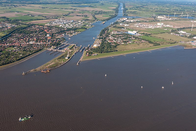
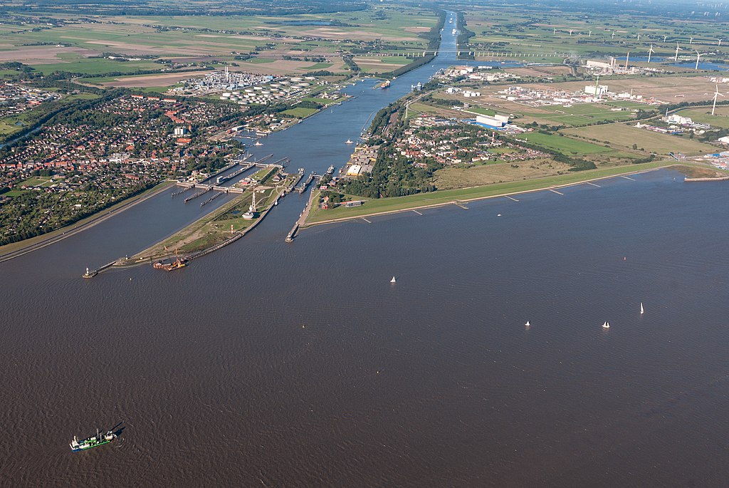
Dansk: Elben, sluserne til Kielerkanalen i Brunsbüttel og viadukten på den føderale hovedvej 5 i baggrunden.
Deutsch: Elbe, Schleusenanlagen des Nord-Ostsee-Kanals in Brunsbüttel und die Hochbrücke der Bundesstraße 5 im Hintergrund.
English: Elbe, locks of the Kiel Canal in Brunsbüttel and the high bridge of the federal highway 5 in the background.
Français : Elbe, écluses du canal de Kiel à Brunsbüttel et le viaduc de l'autoroute fédérale 5 en arrière-plan.
Italiano: Elba, chiuse del Canale di Kiel a Brunsbüttel e sullo sfondo il viadotto dell'autostrada federale 5.
Nederlands: Elbe, sluizen van het Noord-Oostzeekanaal in Brunsbüttel en het viaduct van de rijksweg 5 op de achtergrond.
|
||||||||||||||||||||||||||
| Datum | |||||||||||||||||||||||||||
| Zdroj | Vlastní dílo | ||||||||||||||||||||||||||
| Autor |
|
||||||||||||||||||||||||||
| Svolení (Užití tohoto souboru) |
|
||||||||||||||||||||||||||


| Pozice fotografa | | Tento snímek a mnohé další na: OpenStreetMap |
|---|
Licence

|
Tento dokument smí být kopírován, šířen nebo upravován podle podmínek Svobodné licence GNU pro dokumenty výhradně verze 1.2 publikované nadací Free Software Foundation. Dokument nemá neměnné části ani texty na předním či zadním přebalu. Kopie textu licence je k dispozici v oddíle nazvaném GNU Free Documentation License. | jen 1.2 |
Historie souboru
Kliknutím na datum a čas se zobrazí tehdejší verze souboru.
| Datum a čas | Náhled | Rozměry | Uživatel | Komentář | |
|---|---|---|---|---|---|
| současná | 7. 7. 2018, 16:36 | | 4 052 × 2 710 (6,95 MB) | Ralf Roletschek | Original nicht vedrändern |
| 7. 7. 2018, 16:07 |  | 4 052 × 2 710 (2,85 MB) | 1970gemini | geautobalanced | |
| 3. 10. 2017, 23:53 |  | 4 052 × 2 710 (6,95 MB) | Ralf Roletschek |
Využití souboru
Tento soubor používá následující stránka:
Globální využití souboru
Tento soubor využívají následující wiki:
- Využití na ar.wikipedia.org
- Využití na arz.wikipedia.org
- Využití na ast.wikipedia.org
- Využití na bg.wikipedia.org
- Využití na bn.wikipedia.org
- Využití na ca.wikipedia.org
- Využití na cy.wikipedia.org
- Využití na da.wikipedia.org
- Využití na de.wikipedia.org
- Využití na de.wikivoyage.org
- Využití na en.wikipedia.org
- Využití na en.wikivoyage.org
- Využití na es.wikipedia.org
- Využití na fi.wikipedia.org
- Využití na frr.wikipedia.org
- Využití na he.wikipedia.org
- Využití na hu.wikipedia.org
- Využití na hy.wikipedia.org
- Využití na lv.wikipedia.org
- Využití na my.wikipedia.org
- Využití na ru.wikipedia.org
- Využití na ru.wikivoyage.org
- Využití na sv.wikipedia.org
- Využití na uk.wikipedia.org
- Využití na www.wikidata.org
- Využití na zh-yue.wikipedia.org
- Využití na zh.wikivoyage.org