
Soubor:Spielberg bare map numbers simplified.svg

Velikost tohoto PNG náhledu tohoto SVG souboru: 742 × 600 pixelů. Jiná rozlišení: 297 × 240 pixelů | 594 × 480 pixelů | 950 × 768 pixelů | 1 267 × 1 024 pixelů | 2 533 × 2 048 pixelů | 2 419 × 1 956 pixelů.
Původní soubor (soubor SVG, nominální rozměr: 2 419 × 1 956 pixelů, velikost souboru: 134 KB)
| Tento soubor pochází z Wikimedia Commons. Níže jsou zobrazeny informace, které obsahuje jeho tamější stránka s popisem souboru. |
Popis
| Popis |
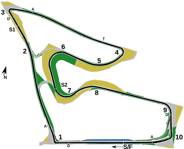
English: This is a map of the w:en:Red Bull Ring, formerly known as the A1-Ring and the Österreichring, in w:en:Spielberg, Austria. It shows the circuit roughly as it has been in the period spanning 2014-2021. Corner numbers are marked with the numbers "1" through "10", the start/finish line is marked as "S/F" with an arrow showing a direction of travel. The marker "S1" shows the end of the first sector, and the marker "S2" shows the end of the second sector. The markers labelled "D" show the w:en:Drag Reduction System detection points for w:en:Formula One, while the markers labelled "A" shows the activation points. The marker labelled "T" shows the speed trap used in Formula One. The location of these markers was sourced from the FIA's official Formula One circuit map. The arrow marked "N" shows the direction of north. The track layout and pit lane entrance and exit are shown in black with a white outline, while the pit lane itself is shown in blue. Green areas mark grass run-off areas, grey areas mark paved run-off areas, and yellow areas mark gravel traps. |
| Datum | |
| Zdroj | Planet Labs, image also available on Wikimedia Commons |
| Autor | I, User:HumanBodyPiloter5, created this SVG map as a derivative work based on the satellite image of the Spielberg circuit released by w:en:Planet Labs under CC-BY-SA 4.0 in 2018 |
Licence
Tento soubor podléhá licenci Creative Commons Uveďte autora-Zachovejte licenci 4.0 International
- Dílo smíte:
- šířit – kopírovat, distribuovat a sdělovat veřejnosti
- upravovat – pozměňovat, doplňovat, využívat celé nebo částečně v jiných dílech
- Za těchto podmínek:
- uveďte autora – Máte povinnost uvést autorství, poskytnout odkaz na licenci a uvést, pokud jste provedli změny. Toho můžete docílit jakýmkoli rozumným způsobem, avšak ne způsobem naznačujícím, že by poskytovatel licence schvaloval nebo podporoval vás nebo vaše užití díla.
- zachovejte licenci – Pokud tento materiál jakkoliv upravíte, přepracujete nebo použijete ve svém díle, musíte své příspěvky šířit pod stejnou nebo slučitelnou licencí jako originál.
Historie souboru
Kliknutím na datum a čas se zobrazí tehdejší verze souboru.
| Datum a čas | Náhled | Rozměry | Uživatel | Komentář | |
|---|---|---|---|---|---|
| současná | 26. 6. 2021, 21:57 | | 2 419 × 1 956 (134 KB) | HumanBodyPiloter5 | Uploaded a work by I, User:HumanBodyPiloter5, created this SVG map as a derivative work based on the satellite image of the Spielberg circuit released by Planet Labs under CC-BY-SA 4.0 in 2018 from [https://medium.com/planet-stories/a-grand-prix-world-tour-86b08d45ae46 Planet Labs], image also available [https://commons.wikimedia.org/wiki/File:Red_Bull_Ring,_April_18,_2018_SkySat.jpg on Wikimedia Commons] with UploadWizard |
Využití souboru
Tento soubor používá následující stránka:
Globální využití souboru
Tento soubor využívají následující wiki:
- Využití na en.wikipedia.org
- Využití na gl.wikipedia.org