
Soubor:Operation-Pleshet-map1.png
Velikost tohoto náhledu: 529 × 600 pixelů. Jiná rozlišení: 212 × 240 pixelů | 423 × 480 pixelů | 900 × 1 020 pixelů.
Původní soubor (900 × 1 020 pixelů, velikost souboru: 152 KB, MIME typ: image/png)
| Tento soubor pochází z Wikimedia Commons. Níže jsou zobrazeny informace, které obsahuje jeho tamější stránka s popisem souboru. |
Popis
| Popis |
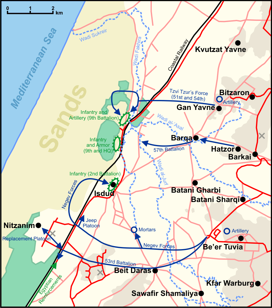
English: Map of the Israeli attacks on Egyptian positions during Operation Pleshet.
Note: The map is as geographically accurate as possible, although since some of the streams were since diverted, and most of the maps from the period do not exactly match, it is difficult to say for sure, and small errors likely exist. |
| Datum | |
| Zdroj | Vlastní dílo |
| Autor | Ynhockey |
| Další verze | File:Operation-Pleshet-map heb.png (Hebrew), File:Operation-Pleshet-map rus.png (Russian) |
Legend
There are four background colors on the map: Green stands for plantations and groves, the brownish color on the left is sand dunes, and the rest is regular ground (darker indicates an elevation of above 50 m)
Lines:
- Red: roads
- Pink: very minor roads or unpaved paths
- Black: railways
- Baby blue: wadis
Other:
- Black circles: villages
- Dark blue lines and arrows: Israeli movement
- Green lines and arrows: Egyptian movement
- Green ellipse: Egyptian position
- Blue cicle: Israeli mortar and field artillery
- Grey X: Former British military base
Sources used in making the map
- Carta's Atlas of Israel (1978), vol. 2, p. 32 (map 46)
- Battle Sites in the Land of Israel (2003), p. 24
- Ayalon, Avraham (1963), Givati Brigade Against the Egyptian Invader, pp. 120, 131
- Palestine Exploration Fund maps (such as here)
- http://www.amudanan.co.il archive copy at the Wayback Machine
Licence
Já, držitel autorských práv k tomuto dílu, ho tímto zveřejňuji za podmínek následujících licencí:
Tento soubor podléhá licenci Creative Commons Uveďte autora-Zachovejte licenci 3.0 Unported
- Dílo smíte:
- šířit – kopírovat, distribuovat a sdělovat veřejnosti
- upravovat – pozměňovat, doplňovat, využívat celé nebo částečně v jiných dílech
- Za těchto podmínek:
- uveďte autora – Máte povinnost uvést autorství, poskytnout odkaz na licenci a uvést, pokud jste provedli změny. Toho můžete docílit jakýmkoli rozumným způsobem, avšak ne způsobem naznačujícím, že by poskytovatel licence schvaloval nebo podporoval vás nebo vaše užití díla.
- zachovejte licenci – Pokud tento materiál jakkoliv upravíte, přepracujete nebo použijete ve svém díle, musíte své příspěvky šířit pod stejnou nebo slučitelnou licencí jako originál.

|
Tento dokument smí být kopírován, šířen nebo upravován podle podmínek Svobodné licence GNU pro dokumenty verze 1.2 nebo libovolné vyšší verze publikované nadací Free Software Foundation. Dokument nemá neměnné části ani texty na předním či zadním přebalu. Kopie textu licence je k dispozici v oddíle nazvaném GNU Free Documentation License. |
Můžete si zvolit libovolnou z těchto licencí.
Historie souboru
Kliknutím na datum a čas se zobrazí tehdejší verze souboru.
| Datum a čas | Náhled | Rozměry | Uživatel | Komentář | |
|---|---|---|---|---|---|
| současná | 3. 8. 2009, 09:56 | | 900 × 1 020 (152 KB) | Ynhockey | Added more info on Egyptian positions |
| 20. 6. 2009, 04:09 |  | 897 × 1 019 (149 KB) | Ynhockey | Added some groves important to the battle, also slightly modified Tzur force's movement | |
| 18. 6. 2009, 00:26 |  | 897 × 1 019 (149 KB) | Ynhockey | Corrected some wadi-related issues | |
| 17. 6. 2009, 23:47 |  | 900 × 1 020 (149 KB) | Ynhockey | More accurate Irgun battle movements, according to the text from Ayalon's book. | |
| 16. 6. 2009, 21:52 |  | 900 × 1 020 (149 KB) | Ynhockey | {{Information |Description={{en|1=Map of the Israeli attacks on Egyptian positions during Operation Pleshet. Note: The map is as geographically accurate as possible, although since some of the streams were since diverted, and most of the maps from the pe |
Využití souboru
Tento soubor používá následující stránka:
Globální využití souboru
Tento soubor využívají následující wiki:
- Využití na de.wikipedia.org
- Využití na en.wikipedia.org
- Využití na es.wikipedia.org
- Využití na pl.wikipedia.org
- Využití na sr.wikipedia.org