
Soubor:Military districts of Russia 2016.svg

Velikost tohoto PNG náhledu tohoto SVG souboru: 800 × 455 pixelů. Jiná rozlišení: 320 × 182 pixelů | 640 × 364 pixelů | 1 024 × 583 pixelů | 1 280 × 728 pixelů | 2 560 × 1 457 pixelů | 1 107 × 630 pixelů.
Původní soubor (soubor SVG, nominální rozměr: 1 107 × 630 pixelů, velikost souboru: 263 KB)
| Tento soubor pochází z Wikimedia Commons. Níže jsou zobrazeny informace, které obsahuje jeho tamější stránka s popisem souboru. |

|
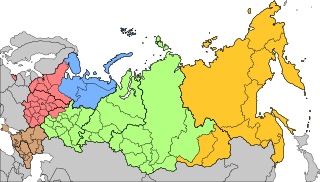
Hranice na této mapě zobrazuji situaci tak, jak de facto je; neznamená to vyjádření uznání či souhlasu se situací. |
Popis
| Popis |
Русский: Военно-административное деление территории Российской Федерации с 15 декабря 2014 года
Западный военный округ
Северный флот
Южный военный округ
Центральный военный округ
Восточный военный округ English: Areas of responsibility of the 5 Operational Strategic Commands of the Russian Armed Forces since Dec 15th, 2014
Western Operational Strategic Command
Northern Fleet
Southern Operational Strategic Command
Central Operational Strategic Command
Eastern Operational Strategic Command |
| Datum | |
| Zdroj | |
| Autor | AlexWelens |

Licence
Já, držitel autorských práv k tomuto dílu, ho tímto zveřejňuji za podmínek následující licence:
Tento soubor podléhá licenci Creative Commons Uveďte autora-Zachovejte licenci 4.0 International
- Dílo smíte:
- šířit – kopírovat, distribuovat a sdělovat veřejnosti
- upravovat – pozměňovat, doplňovat, využívat celé nebo částečně v jiných dílech
- Za těchto podmínek:
- uveďte autora – Máte povinnost uvést autorství, poskytnout odkaz na licenci a uvést, pokud jste provedli změny. Toho můžete docílit jakýmkoli rozumným způsobem, avšak ne způsobem naznačujícím, že by poskytovatel licence schvaloval nebo podporoval vás nebo vaše užití díla.
- zachovejte licenci – Pokud tento materiál jakkoliv upravíte, přepracujete nebo použijete ve svém díle, musíte své příspěvky šířit pod stejnou nebo slučitelnou licencí jako originál.
Historie souboru
Kliknutím na datum a čas se zobrazí tehdejší verze souboru.
| Datum a čas | Náhled | Rozměry | Uživatel | Komentář | |
|---|---|---|---|---|---|
| současná | 24. 12. 2020, 00:56 | | 1 107 × 630 (263 KB) | AlexWelens | fixed islands according map at mil.ru |
| 17. 2. 2017, 17:06 |  | 1 107 × 630 (263 KB) | AlexWelens | Reverted to version as of 16:50, 15 July 2016 (UTC) | |
| 9. 2. 2017, 03:38 |  | 1 107 × 630 (489 KB) | Metrancya | The Northern Fleet area of responsibility is only a part of the area of the new "Unified Strategic Command »North«. All territories north of the Arctic Circle will in the future be governed by the "Unified Strategic Command »North«, which then will... | |
| 15. 7. 2016, 18:50 |  | 1 107 × 630 (263 KB) | AlexWelens | User created page with UploadWizard |
Využití souboru
Tento soubor používají následující 2 stránky:
Globální využití souboru
Tento soubor využívají následující wiki:
- Využití na ar.wikipedia.org
- Využití na ast.wikipedia.org
- Využití na be-tarask.wikipedia.org
- Využití na bg.wikipedia.org
- Využití na da.wikipedia.org
- Využití na de.wikipedia.org
- Využití na en.wikipedia.org
- Využití na es.wikipedia.org
- Využití na et.wikipedia.org
- Využití na fi.wikipedia.org
- Využití na fr.wikipedia.org
- Využití na he.wikipedia.org
- Využití na hu.wikipedia.org
- Využití na it.wikipedia.org
- Využití na ja.wikipedia.org
- Využití na my.wikipedia.org
- Využití na nn.wikipedia.org
Zobrazit další globální využití tohoto souboru.