
Soubor:Island of Ireland location map Kildare.svg

Velikost tohoto PNG náhledu tohoto SVG souboru: 481 × 599 pixelů. Jiná rozlišení: 192 × 240 pixelů | 385 × 480 pixelů | 616 × 768 pixelů | 822 × 1 024 pixelů | 1 643 × 2 048 pixelů | 1 450 × 1 807 pixelů.
Původní soubor (soubor SVG, nominální rozměr: 1 450 × 1 807 pixelů, velikost souboru: 642 KB)
| Tento soubor pochází z Wikimedia Commons. Níže jsou zobrazeny informace, které obsahuje jeho tamější stránka s popisem souboru. |
| Popis |
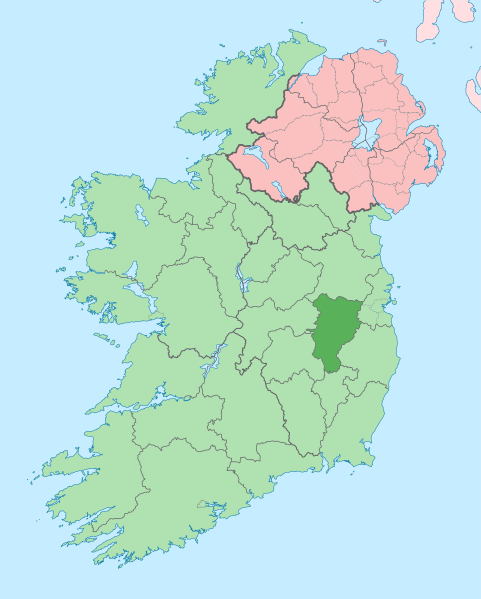
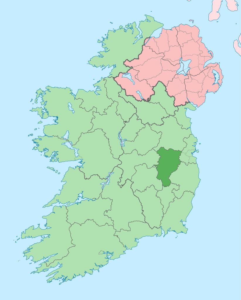
English: The island of Ireland, showing international border between Ireland and Northern Ireland, traditional provinces, traditional counties, and local authority areas in Ireland and Northern Ireland. |
| Datum | (UTC) |
| Zdroj | |
| Autor |
|
| Toto je upravený obrázek, což znamená, že byl oproti původní verzi digitálně změněn. Úpravy: Coloured in regions with county of article highlighted. Původní verzi je možné zhlédnout zde: Island of Ireland location map.svg. Úpravy provedl Mabuska.
|
Já, držitel autorských práv k tomuto dílu, ho tímto zveřejňuji za podmínek následující licence:
Tento soubor podléhá licenci Creative Commons Uveďte autora-Zachovejte licenci 3.0 Unported
- Dílo smíte:
- šířit – kopírovat, distribuovat a sdělovat veřejnosti
- upravovat – pozměňovat, doplňovat, využívat celé nebo částečně v jiných dílech
- Za těchto podmínek:
- uveďte autora – Máte povinnost uvést autorství, poskytnout odkaz na licenci a uvést, pokud jste provedli změny. Toho můžete docílit jakýmkoli rozumným způsobem, avšak ne způsobem naznačujícím, že by poskytovatel licence schvaloval nebo podporoval vás nebo vaše užití díla.
- zachovejte licenci – Pokud tento materiál jakkoliv upravíte, přepracujete nebo použijete ve svém díle, musíte své příspěvky šířit pod stejnou nebo slučitelnou licencí jako originál.
Původní historie souboru
This image is a derivative work of the following images:
- File:Island_of_Ireland_location_map.svg licensed with Cc-by-sa-3.0
- 2010-03-06T20:43:33Z Rannpháirtí anaithnid 1450x1807 (679207 Bytes) Fix incorrectly coloured isands.
- 2010-03-03T22:19:29Z Rannpháirtí anaithnid 1450x1807 (679744 Bytes) {{Information |Description={{de|Positionskarte von [[:de:Irland|Irland]]}} Quadratische Plattkarte, N-S-Streckung 170 %. Geographische Begrenzung der Karte: * N: 55.6° N * S: 51.2° N * W: 11.0° W * O: 5.0° W {{en|Location
Uploaded with derivativeFX
Historie souboru
Kliknutím na datum a čas se zobrazí tehdejší verze souboru.
| Datum a čas | Náhled | Rozměry | Uživatel | Komentář | |
|---|---|---|---|---|---|
| současná | 3. 7. 2020, 11:12 | | 1 450 × 1 807 (642 KB) | Chipmunkdavis | Per the Local Government Reform Act 2014, joining both Tipperarys and both Waterfords (and removing Limerick City code). Colouring in islands, cleaning up and grouping code to remove stray objects and show Galway and Lough Ree. |
| 19. 7. 2010, 02:48 |  | 1 450 × 1 807 (815 KB) | Mabuska | {{Information |Description={{en|The island of Ireland, showing international border between Northern Ireland and Republic of Ireland, traditional provinces, traditional counties, and local authority areas in the Republic of Ireland and Northern Ireland.}} |
Využití souboru
Tento soubor používá následujících 5 stránek:
Globální využití souboru
Tento soubor využívají následující wiki:
- Využití na ar.wikipedia.org
- Využití na ast.wikipedia.org
- Využití na be.wikipedia.org
- Využití na bg.wikipedia.org
- Využití na ca.wikipedia.org
- Comtat de Kildare
- Naas
- Maynooth
- Leixlip
- Plantilla:Comtat Kildare
- Athy
- Newbridge (Kildare)
- Kildare
- Curragh
- Turó d'Allen
- Monasterevin
- Castledermot
- Calverstown
- Allen (Kildare)
- Kilcullen
- Ballymore Eustace
- Rathangan (Kildare)
- Prosperous
- Allenwood
- Caragh
- Clane
- Kill (Kildare)
- Kilcock
- Baile Eoin
- Baile an Mhuilinn (Kildare)
- Využití na ceb.wikipedia.org
- Využití na da.wikipedia.org
- Využití na en.wikipedia.org
Zobrazit další globální využití tohoto souboru.