
Soubor:Gettysburg Day2 Wheatfield1.png
Velikost tohoto náhledu: 800 × 600 pixelů. Jiná rozlišení: 320 × 240 pixelů | 640 × 480 pixelů | 1 024 × 768 pixelů | 1 280 × 960 pixelů | 2 560 × 1 920 pixelů | 4 800 × 3 600 pixelů.
Původní soubor (4 800 × 3 600 pixelů, velikost souboru: 9,56 MB, MIME typ: image/png)
| Tento soubor pochází z Wikimedia Commons. Níže jsou zobrazeny informace, které obsahuje jeho tamější stránka s popisem souboru. |
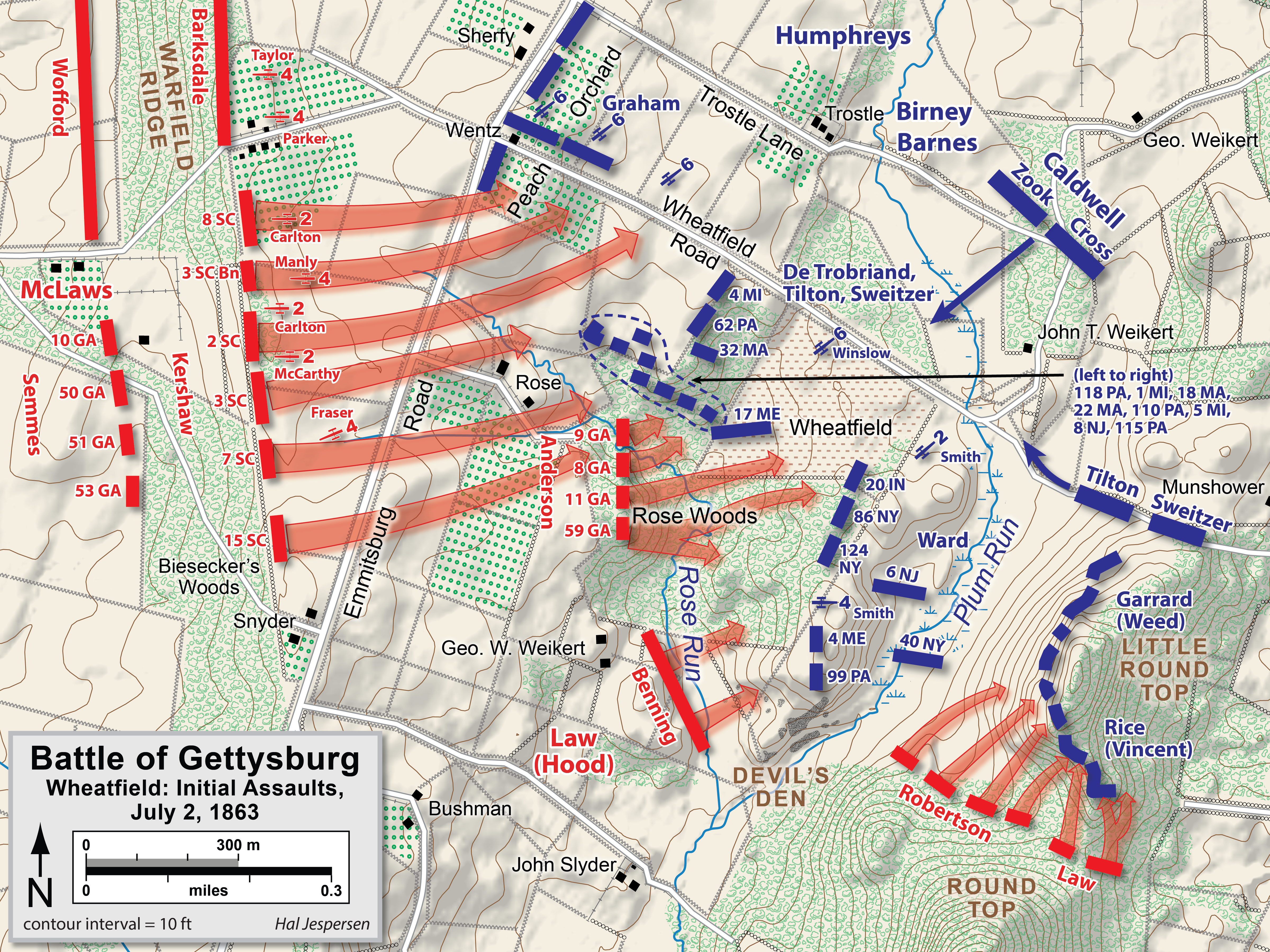
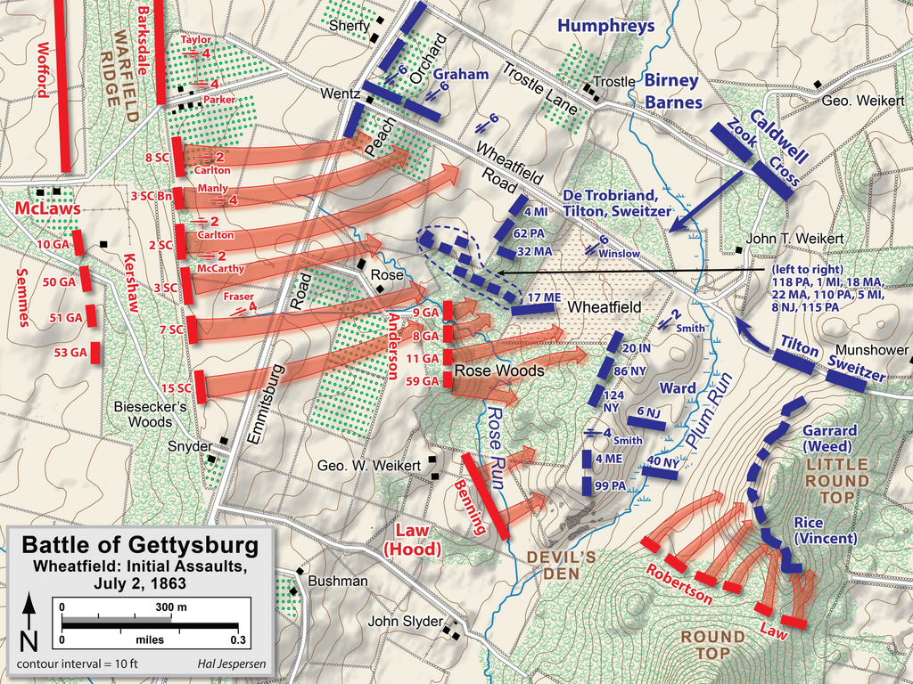
| Popis | Map of Wheatfield actions in the Battle of Gettysburg, Second Day, of the American Civil War. Updated unit positions and made topographical background consistent with many other Wikipedia Gettysburg maps. Drawn in Adobe Illustrator CS5 by Hal Jespersen. Graphic source file is available at http://www.posix.com/CWmaps/ |
| Datum | |
| Zdroj | Vlastní dílo |
| Autor | Hal Jespersen |
Tento soubor podléhá licenci Creative Commons Uveďte autora 3.0 Unported
Uveďte autora: Map by Hal Jespersen, www.posix.com/CW
- Dílo smíte:
- šířit – kopírovat, distribuovat a sdělovat veřejnosti
- upravovat – pozměňovat, doplňovat, využívat celé nebo částečně v jiných dílech
- Za těchto podmínek:
- uveďte autora – Máte povinnost uvést autorství, poskytnout odkaz na licenci a uvést, pokud jste provedli změny. Toho můžete docílit jakýmkoli rozumným způsobem, avšak ne způsobem naznačujícím, že by poskytovatel licence schvaloval nebo podporoval vás nebo vaše užití díla.
Historie souboru
Kliknutím na datum a čas se zobrazí tehdejší verze souboru.
| Datum a čas | Náhled | Rozměry | Uživatel | Komentář | |
|---|---|---|---|---|---|
| současná | 3. 2. 2023, 19:39 | | 4 800 × 3 600 (9,56 MB) | Hlj | improved graphics and detail |
| 2. 4. 2011, 22:03 |  | 2 449 × 1 789 (1,21 MB) | Hlj | Updated graphical format of rivers and roads. Same license. | |
| 31. 7. 2010, 02:04 |  | 2 449 × 1 789 (1,17 MB) | Hlj | New version improves accuracy of unit positions and graphic style that matches others in the Gettysburg series. Added legend box. Drawn by Hal Jespersen in Adobe Illustrator CS5. Graphic source file is available at http://www.posix.com/CWmaps/ {{cc-by-3.0 | |
| 10. 7. 2010, 20:33 |  | 2 449 × 1 789 (1,17 MB) | Hlj | {{Information |Description=Map of Little Round Top (Battle of Gettysburg) of the American Civil War. Updated unit positions and made topographical background consistent with many other Wikipedia Gettysburg maps. Drawn in Adobe Illustrator CS5 by Hal J | |
| 16. 11. 2006, 16:15 |  | 1 483 × 1 203 (510 KB) | Rheo1905~commonswiki | This map is made by en:User:Hlj. 1863. 7. 2. Gettysburg Second Day, Battle of Wheatfield (1) {{PD-release}} |
Využití souboru
Tento soubor používá následující stránka:
Globální využití souboru
Tento soubor využívají následující wiki:
- Využití na da.wikipedia.org
- Využití na en.wikipedia.org
- Využití na hu.wikipedia.org
- Využití na ko.wikipedia.org
- Využití na ru.wikipedia.org
- Využití na zh.wikipedia.org