
Soubor:Enstone-airfield-the-grand-tour-gravel-test-track-20171223.svg

Velikost tohoto PNG náhledu tohoto SVG souboru: 790 × 273 pixelů. Jiná rozlišení: 320 × 111 pixelů | 640 × 221 pixelů | 1 024 × 354 pixelů | 1 280 × 442 pixelů | 2 560 × 885 pixelů.
Původní soubor (soubor SVG, nominální rozměr: 790 × 273 pixelů, velikost souboru: 1,86 MB)
| Tento soubor pochází z Wikimedia Commons. Níže jsou zobrazeny informace, které obsahuje jeho tamější stránka s popisem souboru. |
Popis
| Popis |
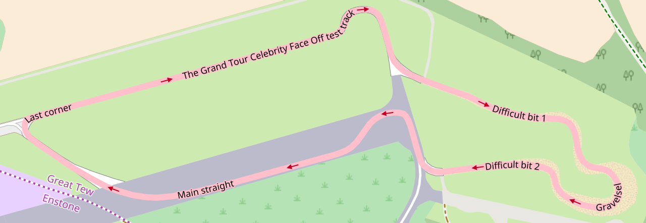
English: w:The Grand Tour (TV series) test track at the former w:RAF Enstone, home of w:Enstone Airfield. The course is constructed of sections of former test track, a redesign of an existing gravel course, and a section on the former main runway—joined together with new asphalt stub sections. Obtained with [1]. |
| Datum | |
| Zdroj | w:OpenStreetMap |
| Autor | OpenStreetMap Contributors. |
| Pozice fotografa | | Tento snímek a mnohé další na: OpenStreetMap |
|---|
Licence
| This work contains information from OpenStreetMap, which is made available under the Open Database License (ODbL).
The ODbL does not require any particular license for maps produced from ODbL data. Prior to 1 August 2020, map tiles produced by the OpenStreetMap Foundation were licensed under the CC-BY-SA-2.0 license. Maps produced by other people may be subject to other licences. |
Historie souboru
Kliknutím na datum a čas se zobrazí tehdejší verze souboru.
| Datum a čas | Náhled | Rozměry | Uživatel | Komentář | |
|---|---|---|---|---|---|
| současná | 23. 12. 2017, 14:25 | 790 × 273 (1,86 MB) | Sladen | User created page with UploadWizard |
Využití souboru
Tento soubor používá následující stránka:
Globální využití souboru
Tento soubor využívají následující wiki:
- Využití na de.wikipedia.org
- Využití na en.wikipedia.org
- Využití na fa.wikipedia.org
- Využití na ru.wikipedia.org
- Využití na zh.wikipedia.org