
Soubor:Deutschen Kolonie Afrika - Togoland.png
Větší rozlišení není k dispozici
Deutschen_Kolonie_Afrika_-_Togoland.png (336 × 371 pixelů, velikost souboru: 50 KB, MIME typ: image/png)
| Tento soubor pochází z Wikimedia Commons. Níže jsou zobrazeny informace, které obsahuje jeho tamější stránka s popisem souboru. |
Popis
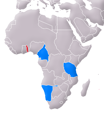
| Popis | Location of Togoland (red) and the other German colonies in Africa (blue) |
| Datum | 06.04.2007 |
| Zdroj | Image:Map of the German Empire.PNG |
| Autor | User:Flor!an |
| Další verze | de:Image:Karte Togo (1914).PNG |
.PNG)
Licence
| Já, autor tohoto díla, jej tímto uvolňuji jako volné dílo, a to celosvětově. V některých zemích to není podle zákona možné; v takovém případě: Poskytuji komukoli právo užívat toto dílo za libovolným účelem, a to bezpodmínečně s výjimkou podmínek vyžadovaných zákonem. |
Historie souboru
Kliknutím na datum a čas se zobrazí tehdejší verze souboru.
| Datum a čas | Náhled | Rozměry | Uživatel | Komentář | |
|---|---|---|---|---|---|
| současná | 6. 5. 2007, 15:03 | | 336 × 371 (50 KB) | Flor!an | {{Information |Description= Location of Togoland (red) and the other German colonies in Africa (blue) |Source= Image:Map of the German Empire.PNG |Date= 06.04.2007 |Author= User:Flor!an |Permission= see below |other_versions= [[Image:Karte Togo ( |
Využití souboru
Tento soubor používá následující stránka:
Globální využití souboru
Tento soubor využívají následující wiki:
- Využití na ca.wikipedia.org
- Využití na da.wikipedia.org
- Využití na es.wikipedia.org
- Využití na fa.wikipedia.org
- Využití na hr.wikipedia.org
- Využití na pt.wikipedia.org
- Využití na sl.wikipedia.org
- Využití na sv.wikipedia.org