
Soubor:Watersnoodramp 1953.jpg
Velikost tohoto náhledu: 746 × 600 pixelů. Jiná rozlišení: 299 × 240 pixelů | 597 × 480 pixelů | 955 × 768 pixelů | 1 274 × 1 024 pixelů | 2 548 × 2 048 pixelů | 2 943 × 2 366 pixelů.
Původní soubor (2 943 × 2 366 pixelů, velikost souboru: 1,94 MB, MIME typ: image/jpeg)
| Tento soubor pochází z Wikimedia Commons. Níže jsou zobrazeny informace, které obsahuje jeho tamější stránka s popisem souboru. |
Popis
| Popis |
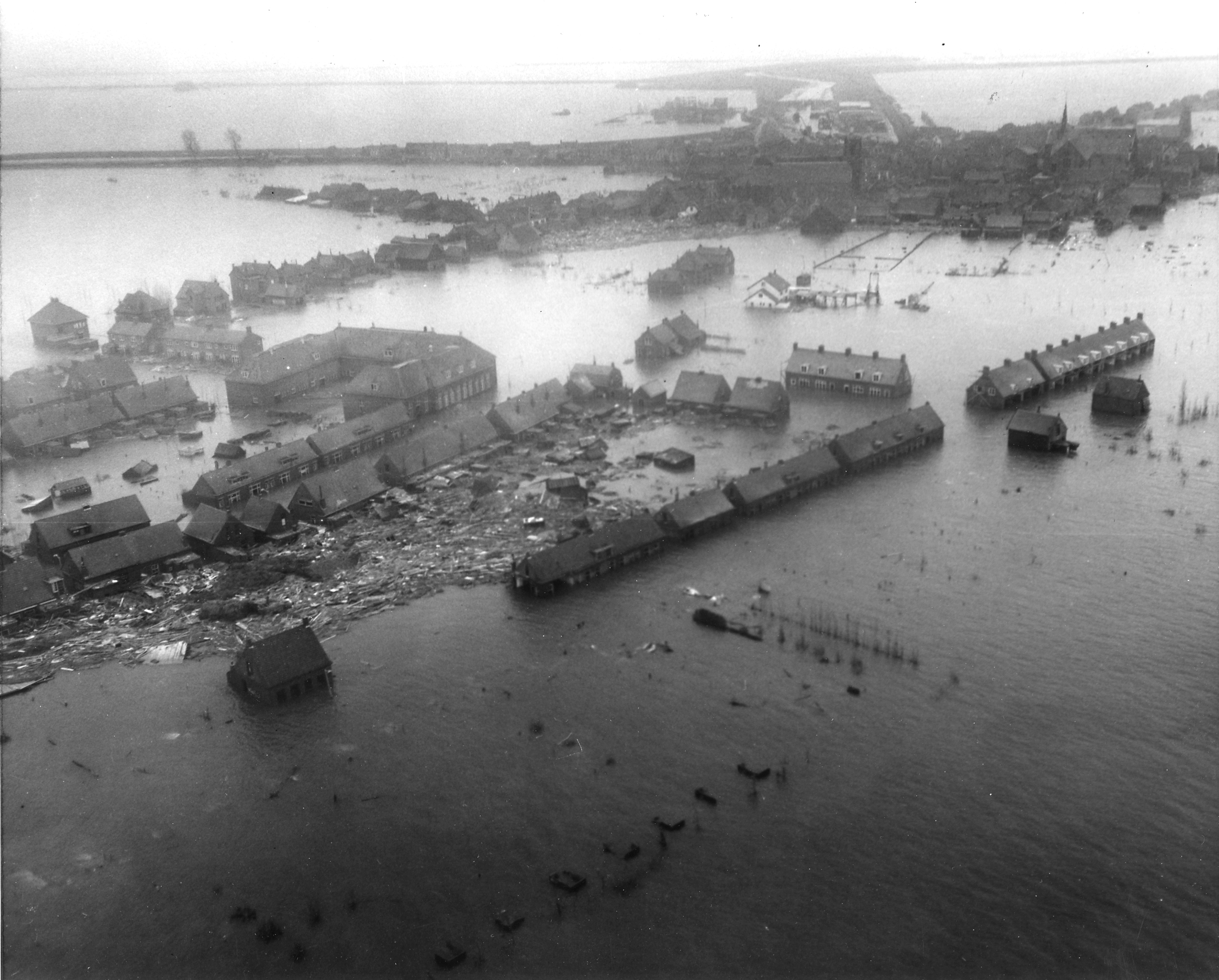
Nederlands: Luchtfoto van het overstroomde dorp Oude Tonge op Goeree-Overflakkee tijdens de Watersnoodramp van 1953. Foto gemaakt vanuit een U.S. Army helicopter.
English: Netherlands. Viewed from a U.S. Army helicopter, gives a hint of the tremendous damage wrought by the flood to Dutch islands. NB Original caption ("Zuid Beveland town") was a false determination of the location, it is actually Oude-Tonge on the island of Goeree-Overflakkee. |
|||
| Datum | ||||
| Zdroj |
|
|||
| Autor | Agency for International Development |
Licence
Toto dílo je ve Spojených státech volným dílem, protože jde o dílo úřadů americké federální vlády podle ustanovení Hlavy 17, Kapitoly 1, Sekce 105 amerického právního řádu. Viz Autorské právo.
Upozornění: uvedené se vztahuje pouze na díla úřadů federální vlády, nikoliv na úřady jednotlivých států, okresů, či nižších územně správních jednotek.
|
 | |
| Bylo zjištěno, že u tohoto souboru nejsou známa žádná omezení daná autorským právem a právy s ním souvisejícími. | ||
Historie souboru
Kliknutím na datum a čas se zobrazí tehdejší verze souboru.
| Datum a čas | Náhled | Rozměry | Uživatel | Komentář | |
|---|---|---|---|---|---|
| současná | 21. 10. 2009, 01:36 | | 2 943 × 2 366 (1,94 MB) | Pieter Kuiper | better resolution from http://narademo.umiacs.umd.edu/cgi-bin/isadg/viewobject.pl?object=78667 |
| 16. 8. 2008, 22:38 |  | 600 × 484 (67 KB) | Pieter Kuiper | {{Information |Description={{en|1=Netherlands. Viewed from a U.S. Army helicopter, a Zuid Beveland town gives a hint of the tremendous damage wrought by the flood to Dutch islands.}} |Source=[http://www.archives.gov/ NARA], ARC Identifier 541705 / Local I |
Využití souboru
Tento soubor používají následující 2 stránky:
Globální využití souboru
Tento soubor využívají následující wiki:
- Využití na ar.wikipedia.org
- Využití na arz.wikipedia.org
- Využití na br.wikipedia.org
- Využití na ca.wikipedia.org
- Využití na cy.wikipedia.org
- Využití na de.wikipedia.org
- Využití na en.wikipedia.org
- Využití na eo.wikipedia.org
- Využití na es.wikipedia.org
- Využití na fa.wikipedia.org
- Využití na fi.wikipedia.org
- Využití na fr.wikipedia.org
- Využití na fy.wikipedia.org
- Využití na gl.wikipedia.org
- Využití na he.wikipedia.org
- Využití na hr.wikipedia.org
- Využití na it.wikipedia.org
- Využití na ja.wikipedia.org
- Využití na ko.wikipedia.org
- Využití na lv.wikipedia.org
- Využití na ms.wikipedia.org
- Využití na nl.wikipedia.org
Zobrazit další globální využití tohoto souboru.