Soubor:Vatican City annex.jpg

Obsah stránky není podporován v jiných jazycích.
Z Wikipedie, otevřené encyklopedie

Původní soubor(1 024 × 818 pixelů, velikost souboru: 318 KB, MIME typ: image/jpeg)

Popis

Popis
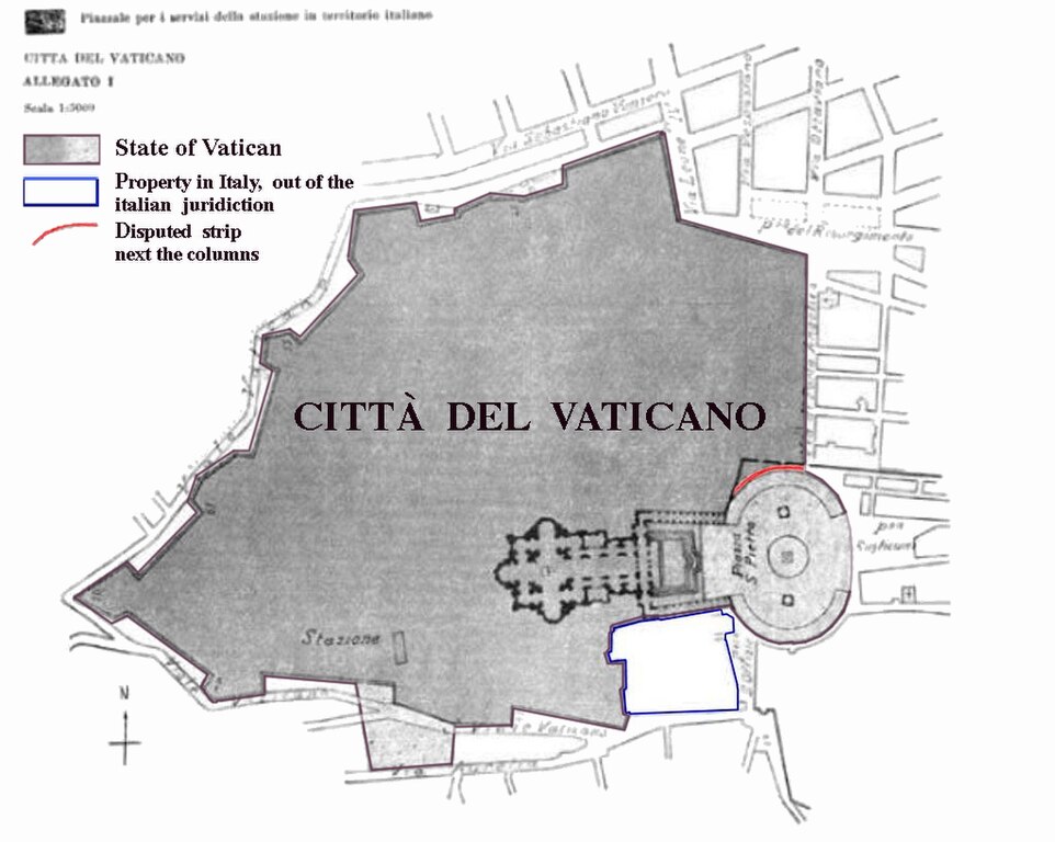
Deutsch: Karte der Vatikanstadt (aus dem Annex der Lateranverträge)
  • dunkelgrau: Territorium der Vatikanstadt
  • hellgrau (Petersplatz): Territorium der Vatikanstadt; Sicherheitsagenden an italienische Sicherheitskräfte delegiert (jederzeit widerrufbar).
  • rot: Der schmale Streifen (ca. 3 m breit und 60 m lang) entlang der Außenseite der rechten (d. h. nördlichen) Kolonnade Berninis ist nach den Lateranverträgen italienisches Territorium und unterliegt der italienischen Jurisdiktion. Diese Tatsache wurde von einer gemischten vatikanisch-italienischen Kommission, die bis 1932 tagte und welche die technischen Details der Verträge präzisierte, bestritten. Da diese Kommission jedoch von italienischen Seite nicht mit hochrangigen Juristen beschickt wurde und darüber hinaus nur beratende Funktion innehatte, wird die rechtliche Relevanz dieses Standpunktes von Italien nicht anerkannt.
  • blau umrandet: Das blauumrandete Gebiet ist zwar italienisches Territorium, steht jedoch im Besitz des Heiligen Stuhls und genießt exterritorialen Status (vergleichbar mit ausländischen Botschaften). Es untersteht nicht der italienischen Jurisdiktion.
  • Sonstiges: Das hellgraue Areal südlich des vatikanischen Bahnhofs (stazione) wurde laut Notiz links unten auf der Karte als "Fläche auf italienischem Territorium zur Versorgung des Bahnhofs" eingefärbt (dieser Bereich wurde in einer Karte der Gazetta Ufficiale von 1929 nicht hellgrau unterlegt). Möglicherweise wurde es dem Heiligen Stuhl aus dem genannten Grund als exterritoriale Besitzung auf italienischem Boden (eine Quelle weist es als solches aus) zur Verfügung gestellt.
English: Boundary map taken from the annex of the Lateran treaties. Colored areas are modifications of original image for purposes of clarification.
  • dark grey: territory of Vatican City.
  • light grey: territory of Vatican City. Security dispositive of Italy. Free access to public and to Italian police authorities may be revoked at any time for special ceremonial occasions.
  • red: The small strip (3 m wide, 60 m long) alongside the northern colonnade is - according to the Lateran treaties - Italian territory and underlies Italian jurisdiction. This fact has been disputed by the mixed Italian-Vatican commission which was in place until 1932 to refine and detail the findings of the treaties. Since this commission had only a consultatory status Italy does not recognize any legal relevance of this dispute.
  • blue zone: territory of Italy, but in possession of the Holy See. The area has extraterritorial status and Italian jurisdiction is not applied. The area contains the seat of the en:Congregation for the Doctrine of the Faith, the bigger part of the en:Paul VI Audience Hall, the Campo Santo Teutonico and the German College.
  • other: The light grey area next to the station has evidently been added in by mistake and is Italian territory.
Français : * gris foncé: territoire de plein-droit de l'état du Saint-Siège.
  • gris clair: territoire de l'état du Saint-Siège où s'appliquent les dispositifs de sécurité de l'Italie. Le libre accès du public et de la police italienne peut être suspendu à tout moment en cas de cérémonies et autres occasions spéciales. Ce statut est valide pour la Place Saint-Pierre mais non pour la zone située à la sortie du chemin de fer au niveau de la gare, qui n'a finalement pas été concédée à l'État du Vatican dans la version définitive du traité.
  • rouge: une bande de territoire large de 3m et longue de 60m le long des colonnes du nord est territoire italien selon le traité, mais jusqu'en 1932 ce fait est contesté par la partie vaticane dans la commission mixte italo-vaticane pour la délimitation. Cette commission n'a qu'un statut consultatif. L'Italie rejette toute contestation et ne reconnaît pas qu'il existerait une dispute. Toutefois de facto c'est l'État du Vatican qui administre ce territoire.
  • liséré bleu: territoire italien, propriété du Saint-Siège bénéficiant du statut d'exterritorialité. La juridiction italienne ne s'y applique pas. Ces bâtiments abritent la Congrégation pour la Doctrine de la Foi (ex-Inquisition), la plus grande partie de la salle d'audience du pape Paul VI et les bureaux de l'Ordre Teutonique.
Română: * gri închis: teritoriu al Vaticanului în plină suveranitate.
  • gri deschis: teritoriu al Vaticanului, în care pot fi aplicate dispozitivele de securitate ale Italiei. Accesul liber pentru public și pentru poliția italiană poate fi suspendat oricând pentru ocazii ceremoniale speciale.
  • roșu: O mică fâșie (lată de 3m, lungă de 60m) de-alungul coloanelor nordice este - în conformitate cu tratatul - teritoriu italian sub jurisdicție italiană, dar este administrat de fapt de Vatican. Fâșia a fost disputată în comisiile mixte italo-vaticane până în 1932 pentru detalierea frontierelor. Deoarece comisia a avut doar statut consultativ, Italia nu recunoaște din punct de vedere legal această dispută.
  • zona albastră: teritoriu italian, proprietate a Sfântulu Scaun. Zona are statut extrateritorial și nu se aplică jurisdicția italiană : ea conține biroul Congregației pentru doctrina credinței (fosta Inchiziție), partea cea mare a sălii de audiență a papei Paul VI, colegiul german și birourile Ordinului Teutonic.
  • altele: zona gri deschis dinafara zidurilor cetății, în dreptul gării, a fost inițial prevăzută ca teritoriu al Vaticanului, dar în versiunea finală a tratatului este teritoriu italian.
Datum
Zdroj Annex of the Lateran Treaty
Autor Original: de:Bild:Vatikanstadt_Annex.jpg, amended by gugganij
Atlas This map has been uploaded by Electionworld from en.wikipedia.org to enable the Wikimedia Atlas of the World . Original uploader to en.wikipedia.org was El Suizo, known as El Suizo at en.wikipedia.org. Electionworld is not the creator of this map. Licensing information is below.

Licence

Public domain

Toto dílo je volné také v zemích, jejichž právní řád chrání majetková autorská práva po dobu života autora a 70 let po jeho smrti.


You must also include a United States public domain tag to indicate why this work is in the public domain in the United States. Note that a few countries have copyright terms longer than 70 years: Mexico has 100 years, Jamaica has 95 years, Colombia has 80 years, and Guatemala and Samoa have 75 years. This image may not be in the public domain in these countries, which moreover do not implement the rule of the shorter term. Honduras has a general copyright term of 75 years, but it does implement the rule of the shorter term. Copyright may extend on works created by French who died for France in World War II (more information), Russians who served in the Eastern Front of World War II (known as the Great Patriotic War in Russia) and posthumously rehabilitated victims of Soviet repressions (more information).

Původní historie souboru

Původní stránka s popisem souboru byla zde. Všechna následující uživatelská jména odkazují na projekt de.wikipedia.
  • 2010-05-16 01:43 Saibo 2283×2098× (1084697 bytes) gedreht (Einnordung) und Legendenelemente verschoben und Untertitel gelöscht
  • 2004-07-30 13:23 Gugganij 2104×2625× (219537 bytes) verkleinert (noch ein Versuch)
  • 2004-07-30 13:21 Gugganij 2104×2625× (219537 bytes) verkleinert
  • 2004-07-26 14:32 Gugganij 2104×2625× (219571 bytes) verkleinert
  • 2004-07-26 14:04 Gugganij 2104×2625× (262857 bytes) Karte der Vatikanstadt (aus dem [[Annex]] der [[Lateranverträge]]), [[Public domain]], bearbeitet von [[Benutzer:gugganij|gugganij]]

Popisky

Přidejte jednořádkové vysvětlení, co tento soubor představuje
Zdiecie

Položky vyobrazené v tomto souboru

zobrazuje

11. 2. 1929gregoriánský

Historie souboru

Kliknutím na datum a čas se zobrazí tehdejší verze souboru.

Datum a časNáhledRozměryUživatelKomentář
současná25. 7. 2014, 18:51Náhled verze z 25. 7. 2014, 18:511 024 × 818 (318 KB)Spiridon Ion CepleanuNew version with legend
1. 4. 2011, 14:00Náhled verze z 1. 4. 2011, 14:002 096 × 2 625 (261 KB)RotatebotBot: Rotate 90°
21. 12. 2006, 00:37Náhled verze z 21. 12. 2006, 00:372 625 × 2 104 (261 KB)Electionworld{{ew|en|El Suizo}} *Description: Boundary map taken from the annex of the lateran treaties. Colored areas are modifications of original image for purposes of clarification. *Source: German Wikipedia ==Details== * '''dark grey''': territory of Vatican Cit

Tento soubor používá následující stránka:

Globální využití souboru

Tento soubor využívají následující wiki:

Zobrazit další globální využití tohoto souboru.

Metadata