
Soubor:Storm in Bagram.jpg

Původní soubor (1 024 × 633 pixelů, velikost souboru: 260 KB, MIME typ: image/jpeg)
| Tento soubor pochází z Wikimedia Commons. Níže jsou zobrazeny informace, které obsahuje jeho tamější stránka s popisem souboru. |
Popis
| Popis |
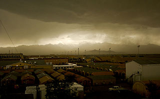
A storm rolls into Bagram Air Field, Afghanistan, April 20. The 455th Expeditionary Operations Support Squadron, combat weather team, uses a variety of techniques to predict weather. They use of a Mark IV satellite and visual reference to determine type and severity of storm to better prepare personnel on BAF to maintain mission effectiveness. Rainstorms are frequent this time of year and have the ability to change the landscape to include rivers and streams. With the lack of drainage systems, floods occur regularly throughout the southeast region of Afghanistan. Precipitation in east and southeast regions is about forty centimeters per year. 455th Air Expeditionary Wing Photo by Senior Airman Erik Cardenas Date: 04.20.2009 Location: BAGRAM AIR FIELD, AF Related photos: dvidshub.net/r/zk92xz |
| Datum | Snímek pořízen 20. dubna 2009, 15:29 |
| Zdroj | Storm in Bagram |
| Autor | DVIDSHUB |
Licence
- Dílo smíte:
- šířit – kopírovat, distribuovat a sdělovat veřejnosti
- upravovat – pozměňovat, doplňovat, využívat celé nebo částečně v jiných dílech
- Za těchto podmínek:
- uveďte autora – Máte povinnost uvést autorství, poskytnout odkaz na licenci a uvést, pokud jste provedli změny. Toho můžete docílit jakýmkoli rozumným způsobem, avšak ne způsobem naznačujícím, že by poskytovatel licence schvaloval nebo podporoval vás nebo vaše užití díla.
| This image was originally posted to Flickr by DVIDSHUB at https://www.flickr.com/photos/28650594@N03/3483547353. It was reviewed on 18. května 2009 by FlickreviewR and was confirmed to be licensed under the terms of the cc-by-2.0. |
Historie souboru
Kliknutím na datum a čas se zobrazí tehdejší verze souboru.
| Datum a čas | Náhled | Rozměry | Uživatel | Komentář | |
|---|---|---|---|---|---|
| současná | 17. 5. 2009, 22:49 | | 1 024 × 633 (260 KB) | Geo Swan | {{Information |Description= A storm rolls into Bagram Air Field, Afghanistan, April 20. The 455th Expeditionary Operations Support Squadron, combat weather team, uses a variety of techniques to predict weather. They use of a Mark IV satellite and visual r |
Využití souboru
Tento soubor používá následující stránka:
Globální využití souboru
Tento soubor využívají následující wiki:
- Využití na sk.wikipedia.org