
Soubor:Pre-roman iron age (map).PNG
Velikost tohoto náhledu: 577 × 600 pixelů. Jiná rozlišení: 231 × 240 pixelů | 462 × 480 pixelů | 657 × 683 pixelů.
Původní soubor (657 × 683 pixelů, velikost souboru: 38 KB, MIME typ: image/png)
| Tento soubor pochází z Wikimedia Commons. Níže jsou zobrazeny informace, které obsahuje jeho tamější stránka s popisem souboru. |
Popis
| Popis |
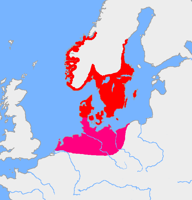
English: Map of the Nordic Iron Age and the Jastorf culture. |
||
| Datum | |||
| Zdroj | Image:Europe plain rivers.png and the Harper Atlas of World History (ed. Vidal-Naquet) in Swedish translation: Atlas över mänsklighetens historia. | ||
| Autor | Copied from en:, uploaded by Wiglaf | ||
| Další verze |
|

.PNG)
Licence
| Wiglaf, autor tohoto díla, jej uvolnil jako volné dílo, a to celosvětově. V některých zemích to není podle zákona možné; v takovém případě: |
Historie souboru
Kliknutím na datum a čas se zobrazí tehdejší verze souboru.
| Datum a čas | Náhled | Rozměry | Uživatel | Komentář | |
|---|---|---|---|---|---|
| současná | 8. 8. 2017, 07:43 | | 657 × 683 (38 KB) | Velivieras | Updated the map concerning the Åland islands. Scandinavian influence to the island started in 11th century. |
| 15. 8. 2005, 09:26 |  | 657 × 683 (32 KB) | Square87~commonswiki | from en.wiki {{PD}} |
Využití souboru
Tento soubor používá následující stránka:
Globální využití souboru
Tento soubor využívají následující wiki:
- Využití na af.wikipedia.org
- Využití na als.wikipedia.org
- Využití na ast.wikipedia.org
- Využití na be.wikipedia.org
- Využití na ca.wikipedia.org
- Využití na ca.wiktionary.org
- Využití na da.wikipedia.org
- Využití na da.wikibooks.org
- Využití na de.wikipedia.org
- Využití na eml.wikipedia.org
- Využití na en.wikipedia.org
- Využití na eo.wikipedia.org
- Využití na es.wikipedia.org
- Využití na et.wikipedia.org
- Využití na eu.wikipedia.org
- Využití na fa.wikipedia.org
- Využití na fi.wikipedia.org
- Využití na fi.wikibooks.org
- Využití na fr.wikipedia.org
- Využití na fr.wikiversity.org
- Využití na fr.wiktionary.org
- Využití na fy.wikipedia.org
- Využití na gl.wikipedia.org
Zobrazit další globální využití tohoto souboru.
.PNG)
.PNG)