
Soubor:Persian Empire, 490 BC.png
Velikost tohoto náhledu: 800 × 577 pixelů. Jiná rozlišení: 320 × 231 pixelů | 640 × 461 pixelů | 946 × 682 pixelů.
Původní soubor (946 × 682 pixelů, velikost souboru: 159 KB, MIME typ: image/png)
| Tento soubor pochází z Wikimedia Commons. Níže jsou zobrazeny informace, které obsahuje jeho tamější stránka s popisem souboru. |
Popis
| Popis |
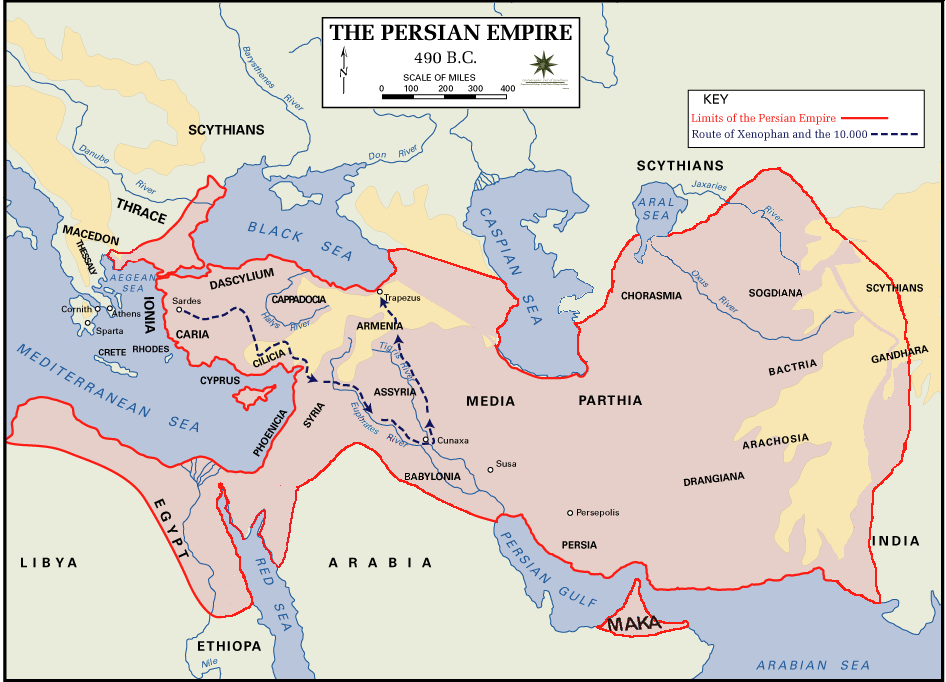
 English: Persian Empire, 490 BC, showing route of Cyrus the Younger, Xenophon and the 10.000.
Legends:
|
| Datum | |
| Zdroj | The Department of History - United States Military Academy |
| Autor | DHUSMA |
| Svolení (Užití tohoto souboru) |
In the public domain as original works of the United States federal government and/or military |
| Další verze | For a version of this image altered to display better in Wikipedia articles (converted to PNG format, slightly cropped in File:Persian Empire, 490 BC.gif) y Italian version. |

|
Tento obrázek (skupina historical map) by měl být vytvořen pomocí vektorové grafiky jako SVG soubor. To má několik výhod; podrobnosti najdete na stránce Commons:Media for cleanup. Je-li SVG verze tohoto obrázku již k dispozici, prosím nahrajte ji. Po nahrání nahraďte tuto šablonu šablonou {{Vector version available|jméno nového obrázku.svg}}.
|
Licence
Toto dílo je ve Spojených státech volným dílem, protože jde o dílo úřadů americké federální vlády podle ustanovení Hlavy 17, Kapitoly 1, Sekce 105 amerického právního řádu. Viz Autorské právo.
Upozornění: uvedené se vztahuje pouze na díla úřadů federální vlády, nikoliv na úřady jednotlivých států, okresů, či nižších územně správních jednotek.
|
 | |
| Bylo zjištěno, že u tohoto souboru nejsou známa žádná omezení daná autorským právem a právy s ním souvisejícími. | ||
Historie souboru
Kliknutím na datum a čas se zobrazí tehdejší verze souboru.
| Datum a čas | Náhled | Rozměry | Uživatel | Komentář | |
|---|---|---|---|---|---|
| současná | 2. 8. 2015, 04:11 | | 946 × 682 (159 KB) | History of Persia | Achaemenid Arabia. see wikipedia article about achaemenid arabia |
| 11. 4. 2013, 13:21 |  | 942 × 684 (64 KB) | HistoryofIran | {{subst:Upload marker added by en.wp UW}} {{Information |Description = {{en|Added another region named Maka, it was listen on the Behistun inscription as part of the Achaemenid Empire.}} |Source = https://en.wikipedia.org/wiki/File:Persian_Empire,_490_... | |
| 10. 4. 2013, 21:21 |  | 942 × 684 (64 KB) | HistoryofIran | Changed where Chorasmia was written, it was much closer to the Aral sea. | |
| 10. 4. 2013, 21:19 |  | 942 × 684 (64 KB) | HistoryofIran | Added a more accurate map. | |
| 8. 12. 2012, 00:55 |  | 942 × 684 (64 KB) | Geagea | Colchis and Caucasian Iberia. Not Georgia. | |
| 25. 11. 2012, 18:24 |  | 942 × 684 (97 KB) | SilvioRusso | correction | |
| 27. 8. 2009, 02:49 |  | 942 × 684 (64 KB) | AnonMoos | Version of File:Persian Empire, 490 BC.gif altered to display better in Wikipedia articles (converted to PNG format, slightly cropped). == Summary == ; Description : Persian Empire, 490 BC ; Author/Source : [http://www.dean.usma.edu/history/ The Depa |
Využití souboru
Tento soubor používá následující stránka:
Globální využití souboru
Tento soubor využívají následující wiki:
- Využití na ast.wikipedia.org
- Využití na bg.wikipedia.org
- Využití na ca.wikipedia.org
- Využití na da.wikipedia.org
- Využití na el.wikipedia.org
- Využití na en.wikipedia.org
- Využití na eo.wikipedia.org
- Využití na eu.wikipedia.org
- Využití na fa.wikipedia.org
- Využití na fr.wikipedia.org
- Využití na fr.wikisource.org
- Využití na fy.wikipedia.org
- Využití na hr.wikipedia.org
- Využití na hu.wikipedia.org
- Využití na hy.wikipedia.org
- Využití na id.wikipedia.org
- Využití na it.wikipedia.org
- Využití na ko.wikipedia.org
- Využití na ku.wikipedia.org
- Využití na la.wikipedia.org
- Využití na nl.wikipedia.org
- Využití na no.wikipedia.org
- Využití na pnb.wikipedia.org
- Využití na pnt.wikipedia.org
- Využití na ro.wikipedia.org
- Využití na ru.wikipedia.org
- Využití na sh.wikipedia.org
- Využití na sr.wikipedia.org
Zobrazit další globální využití tohoto souboru.