
Soubor:OoNL1786.png
OoNL1786.png (565 × 481 pixelů, velikost souboru: 539 KB, MIME typ: image/png)
| Tento soubor pochází z Wikimedia Commons. Níže jsou zobrazeny informace, které obsahuje jeho tamější stránka s popisem souboru. |
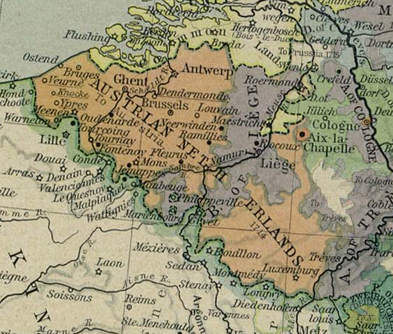
- Description: Cropped version of a map of Europe in 1786. From The Historical Atlas by William R. Shepherd, 1926.
Popis
Austrian Netherlands 1786. This picture is from the collection of the University of Texas (http://www.lib.utexas.edu/maps/historical/history_europe.html). These maps are under public domain (http://www.lib.utexas.edu/maps/faq.html#3.html).
Licence
|
Toto dílo je volné také v zemích, jejichž právní řád chrání majetková autorská práva po dobu života autora a 70 let po jeho smrti.
| |
| Bylo zjištěno, že u tohoto souboru nejsou známa žádná omezení daná autorským právem a právy s ním souvisejícími. | |

|
Tento obrázek (skupina old map) by měl být vytvořen pomocí vektorové grafiky jako SVG soubor. To má několik výhod; podrobnosti najdete na stránce Commons:Media for cleanup. Je-li SVG verze tohoto obrázku již k dispozici, prosím nahrajte ji. Po nahrání nahraďte tuto šablonu šablonou {{Vector version available|jméno nového obrázku.svg}}.
|
Historie souboru
Kliknutím na datum a čas se zobrazí tehdejší verze souboru.
| Datum a čas | Náhled | Rozměry | Uživatel | Komentář | |
|---|---|---|---|---|---|
| současná | 5. 2. 2006, 00:31 | | 565 × 481 (539 KB) | Stullkowski | Austrian Netherlands 1786. This picture is from the collection of the University of Texas (http://www.lib.utexas.edu/maps/). These maps are under public domain (http://www.lib.utexas.edu/maps/faq.html#3.html). |
Využití souboru
Tento soubor používají následující 3 stránky:
Globální využití souboru
Tento soubor využívají následující wiki:
- Využití na af.wikipedia.org
- Využití na ast.wikipedia.org
- Využití na br.wikipedia.org
- Využití na ca.wikipedia.org
- Využití na da.wikipedia.org
- Využití na de.wikipedia.org
- Využití na en.wikipedia.org
- Využití na eo.wikipedia.org
- Využití na et.wikipedia.org
- Využití na fi.wikipedia.org
- Využití na fr.wikipedia.org
- Využití na gl.wikipedia.org
- Využití na he.wikipedia.org
- Využití na hu.wikipedia.org
- Využití na it.wikipedia.org
- Využití na ja.wikipedia.org
- Využití na lb.wikipedia.org
- Využití na lmo.wikipedia.org
- Využití na lt.wikipedia.org
- Využití na lv.wikipedia.org
- Využití na ms.wikipedia.org
- Využití na nl.wikipedia.org
- Verenigde Nederlandse Staten
- Oostkantons
- Oostenrijkse Nederlanden
- Portaal:België
- Portaal:Tachtigjarige Oorlog/Tijdlijn
- Portaal:Tachtigjarige Oorlog/Tijdlijn/Overzicht
- Portaal:Tachtigjarige Oorlog
- Vrede van Leoben
- Portaal:Vroegmoderne Tijd/Uitgelicht
- Portaal:Vroegmoderne Tijd/Uitgelicht/32
- Portaal:België/Geschiedenis
Zobrazit další globální využití tohoto souboru.