
Soubor:Montjuïc circuit.svg

Velikost tohoto PNG náhledu tohoto SVG souboru: 800 × 531 pixelů. Jiná rozlišení: 320 × 212 pixelů | 640 × 425 pixelů | 1 024 × 680 pixelů | 1 280 × 850 pixelů | 2 560 × 1 700 pixelů | 1 512 × 1 004 pixelů.
Původní soubor (soubor SVG, nominální rozměr: 1 512 × 1 004 pixelů, velikost souboru: 318 KB)
| Tento soubor pochází z Wikimedia Commons. Níže jsou zobrazeny informace, které obsahuje jeho tamější stránka s popisem souboru. |
Popis
| Popis |
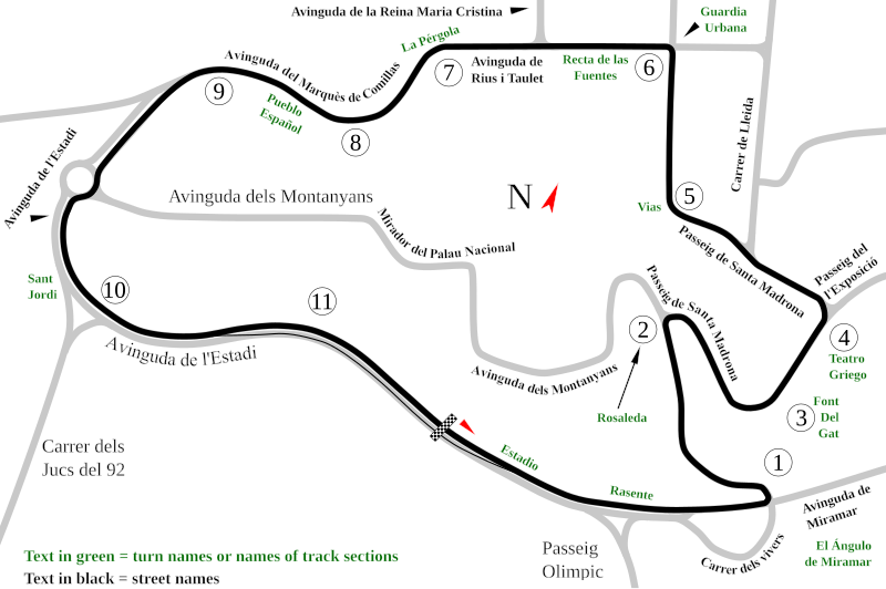
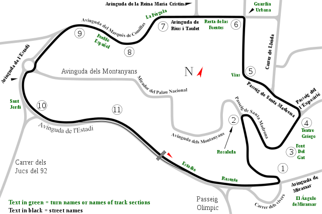
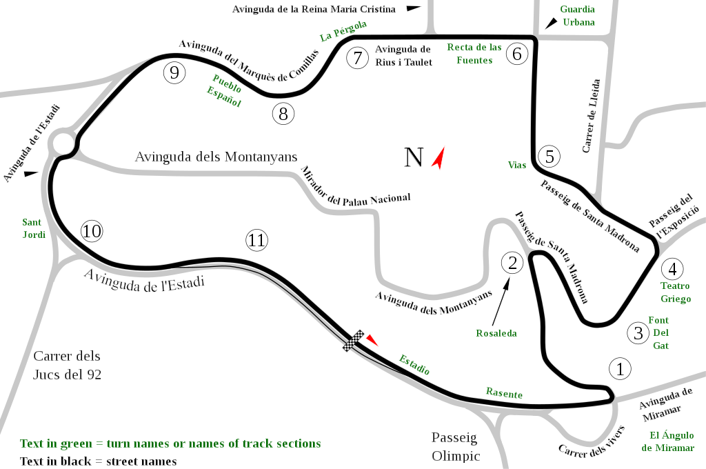
English: Track map of Montjuïc circuit. Gray lines are streets. Green text are either turn names or track section names. Black text (with out the circle) are street names. |
| Datum | |
| Zdroj | Vlastní dílo |
| Autor | Will Pittenger |
| Další verze |
|

| Pozice fotografa | | Tento snímek a mnohé další na: OpenStreetMap |
|---|
Licence
| Já, autor tohoto díla, jej tímto uvolňuji jako volné dílo, a to celosvětově. V některých zemích to není podle zákona možné; v takovém případě: Poskytuji komukoli právo užívat toto dílo za libovolným účelem, a to bezpodmínečně s výjimkou podmínek vyžadovaných zákonem. |
Historie souboru
Kliknutím na datum a čas se zobrazí tehdejší verze souboru.
| Datum a čas | Náhled | Rozměry | Uživatel | Komentář | |
|---|---|---|---|---|---|
| současná | 19. 7. 2008, 14:55 | | 1 512 × 1 004 (318 KB) | Will Pittenger | Once again, please use the previous version if you need to edit the file. |
| 19. 7. 2008, 14:54 |  | 1 512 × 1 004 (128 KB) | Will Pittenger | Corrected typos. The text objects that were on paths are back on paths. | |
| 19. 7. 2008, 14:20 |  | 1 512 × 1 004 (318 KB) | Will Pittenger | Mediawiki/RSVG has problems with text on paths. It tends to hide such text objects. This version gets around that bug by converting such objects to paths. If you need to edit the file, please use the previous version. | |
| 19. 7. 2008, 14:17 |  | 1 512 × 1 004 (128 KB) | Will Pittenger | New version has keywords added. | |
| 19. 7. 2008, 13:58 |  | 1 512 × 1 004 (127 KB) | Will Pittenger | This version fixes the document size. | |
| 19. 7. 2008, 13:54 |  | 744 × 1 052 (126 KB) | Will Pittenger | {{Information |Description={{en|1=Track map of w:Montjuïc circuit. Gray lines are streets. Green text are either turn names or track section names. Black text (with out the circle) are street names.}} |Source=Own work by uploader |Author=[[User:W |
Využití souboru
Tento soubor používá následujících 9 stránek:
Globální využití souboru
Tento soubor využívají následující wiki:
- Využití na af.wikipedia.org
- Využití na ar.wikipedia.org
- Využití na ast.wikipedia.org
- Využití na bg.wikipedia.org
- Využití na bn.wikipedia.org
- Využití na br.wikipedia.org
- Využití na ca.wikipedia.org
- Circuit de Montjuïc
- 24 Hores de Montjuïc
- Gran Premi d'Espanya de motociclisme de 1964
- Gran Premi d'Espanya de motociclisme de 1965
- Gran Premi d'Espanya de motociclisme de 1966
- Gran Premi d'Espanya de motociclisme de 1968
- Gran Premi d'Espanya de motociclisme de 1974
- Gran Premi d'Espanya de motociclisme de 1961
- Gran Premi d'Espanya de motociclisme de 1962
- Gran Premi d'Espanya de motociclisme de 1963
- Gran Premi d'Espanya de motociclisme de 1967
- Gran Premi d'Espanya de motociclisme de 1970
- 24 Hores de Montjuïc 1961
- 24 Hores de Montjuïc 1962
- 24 Hores de Montjuïc 1965
- 24 Hores de Montjuïc 1968
- 24 Hores de Montjuïc 1973
- 24 Hores de Montjuïc 1977
- 24 Hores de Montjuïc 1979
- 24 Hores de Montjuïc 1981
- 24 Hores de Montjuïc 1982
- 24 Hores de Montjuïc 1984
- 24 Hores de Montjuïc 1985
- Využití na de.wikipedia.org
- Využití na en.wikipedia.org
Zobrazit další globální využití tohoto souboru.