
Soubor:Isla Brasilera 57.62646W 30.18248S.jpg

Velikost tohoto náhledu: 800 × 600 pixelů. Jiná rozlišení: 320 × 240 pixelů | 640 × 480 pixelů | 1 024 × 768 pixelů.
Původní soubor (1 024 × 768 pixelů, velikost souboru: 303 KB, MIME typ: image/jpeg)
| Tento soubor pochází z Wikimedia Commons. Níže jsou zobrazeny informace, které obsahuje jeho tamější stránka s popisem souboru. |
Popis
| Popis |
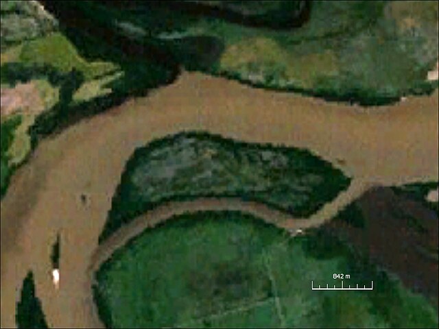
English: Isla Brasilera, river island, northern Uruguay/southeastern Argentina |
| Datum | cca 2000 |
| Zdroj | NASA World Wind Screenshot |
| Autor | NASA |
Licence
| This image is in the public domain because it is a screenshot from NASA’s globe software World Wind using a public domain layer, such as Blue Marble, MODIS, Landsat, SRTM, USGS or GLOBE.
|
 |
Historie souboru
Kliknutím na datum a čas se zobrazí tehdejší verze souboru.
| Datum a čas | Náhled | Rozměry | Uživatel | Komentář | |
|---|---|---|---|---|---|
| současná | 6. 4. 2010, 21:44 | | 1 024 × 768 (303 KB) | Ratzer | {{Information |Description={{en|1=Isla Brasilera, river island, northern Uruguay/southeastern Argentina}} |Source=NASA World Wind Screenshot |Author=NASA |Date=2000? |Permission= |other_versions= }} Category:River Island [[Category:Disputed territori |
Využití souboru
Tento soubor používá následující stránka:
Globální využití souboru
Tento soubor využívají následující wiki:
- Využití na arz.wikipedia.org
- Využití na ca.wikipedia.org
- Využití na ceb.wikipedia.org
- Využití na de.wikipedia.org
- Využití na he.wikipedia.org
- Využití na pt.wikipedia.org
- Využití na vi.wikipedia.org
- Využití na www.wikidata.org