
Soubor:Historical map of the Balkans around 582-612 AD.jpg
Původní soubor (1 688 × 1 977 pixelů, velikost souboru: 476 KB, MIME typ: image/jpeg)
| Tento soubor pochází z Wikimedia Commons. Níže jsou zobrazeny informace, které obsahuje jeho tamější stránka s popisem souboru. |
Popis
| Popis |
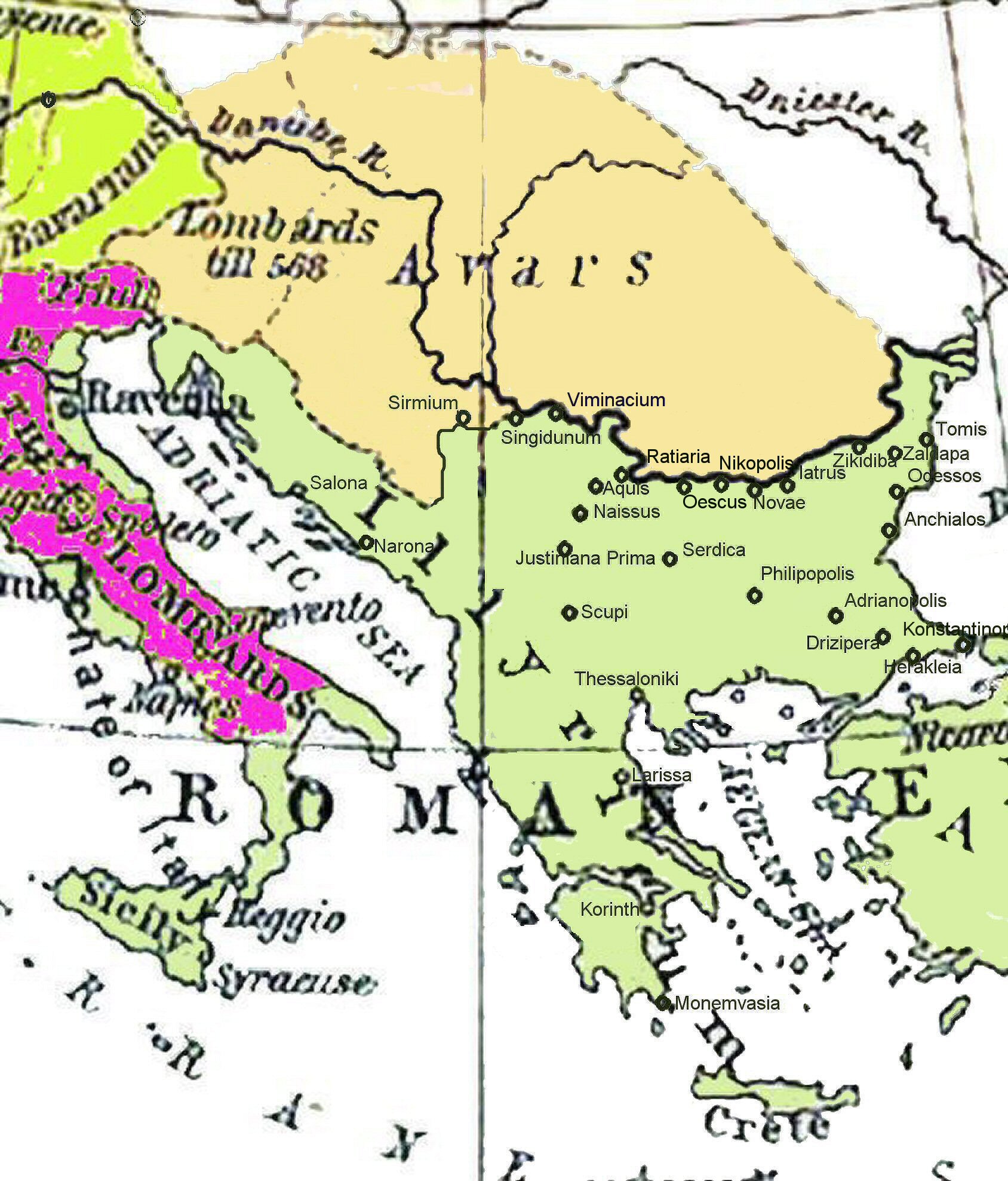
Български: Балканския Полуостров 582-612.
Deutsch: Diese Karte gibt einen Überblick über den Balkan zur Zeit der Kaiser Maurikios und Phokas, insbesondere über die Städte, in deren Umgebung die Kampfhandlungen während der Balkanfeldzüge des Maurikios statt fanden. Das Reich der Awaren. Der Balkan 582-612.
English: Historical map of the Balkans around 582-612 AD showing the Avar Khaganate, Byzantine (Eastern Roman) Empire.
Español: Mapa mostrando la localización del Jaganato de los Ávaros hacia 600 d. C.
Italiano: Il khaganato avaro dal 582 al 615 circa. La locazione del khanato Avaro verso il 600. I Balcani dal 582 al 615.
日本語: 600年頃のアヴァール(Avars)と東ローマ(ROMAN EMPIRE)。.
Română: Imperiul Avar.
Srpskohrvatski / српскохрватски: Balkan 582-612.
Slovenščina: Karta Balkana okoli leta 600.
Shqip: Ballkani në vitet 582 – 612 para dyndjeve sllave. Der Balkan 582–612.
Svenska: Avarernas rike på 600-talet.
ไทย: แผนที่แสดงตำแหน่งของอาณาจักรข่านของอาวาร์ราว ค.ศ. 600.
Türkçe: 600'lü yıllarda Avar Kağanlığı. 600'lü yıllarda Avar toprakları. |
| Datum | 04.11.2006 |
| Zdroj | Ursprung Shepherd, William: Historical Atlas. New York: Henry Holt and Company, 1911 |
| Tvůrce |
William Shepherd R. (1871-1934); Wolf Halama (nur der hier überarbeitete Kartenausschnitt) |
| Georeferencing | If inappropriate please set warp_status = skip to hide. |
Licence
|
Toto dílo je volné také v zemích, jejichž právní řád chrání majetková autorská práva po dobu života autora a 70 let po jeho smrti.
| |
| Bylo zjištěno, že u tohoto souboru nejsou známa žádná omezení daná autorským právem a právy s ním souvisejícími. | |
Původní historie souboru
Na Commons přenesl z de.wikipedia uživatel Roberta F. pomocí nástroje CommonsHelper.
- 2007-04-14 10:29 Hungerhahn 1688×1977× (487589 bytes) {{Information |Beschreibung = |Quelle = |Urheber = |Datum = |Genehmigung = |Andere Versionen = |Anmerkungen = }}
- 2007-03-16 19:01 Hungerhahn 1688×1977× (477133 bytes) {{Information |Beschreibung = |Quelle = |Urheber = |Datum = |Genehmigung = |Andere_Versionen = |Anmerkungen = }}
- 2007-03-16 18:58 Hungerhahn 1688×1977× (477133 bytes) {{Information |Beschreibung = |Quelle = |Urheber = |Datum = |Genehmigung = |Andere_Versionen = |Anmerkungen = }}
- 2007-03-16 18:55 Hungerhahn 1688×1977× (477133 bytes) {{Information |Beschreibung = |Quelle = |Urheber = |Datum = |Genehmigung = |Andere_Versionen = |Anmerkungen = }}
- 2006-11-04 18:51 Hungerhahn 1688×1977× (474804 bytes) {{Information |Beschreibung= Der Balkan Ende des 6. Jahrhunderts |Quelle= |Urheber=Wolf Halama |Datum=04.11.2006 |Genehmigung= |Andere Versionen= |Anmerkungen= }}
Historie souboru
Kliknutím na datum a čas se zobrazí tehdejší verze souboru.
| Datum a čas | Náhled | Rozměry | Uživatel | Komentář | |
|---|---|---|---|---|---|
| současná | 9. 8. 2009, 18:43 | | 1 688 × 1 977 (476 KB) | File Upload Bot (Magnus Manske) | {{BotMoveToCommons|de.wikipedia|year={{subst:CURRENTYEAR}}|month={{subst:CURRENTMONTHNAME}}|day={{subst:CURRENTDAY}}}} {{Information |Description={{de|Diese Karte gibt einen Überblick über den Balkan zur Zeit der Kaiser de:Maurikios und [[:de:Pho |
Využití souboru
Globální využití souboru
Tento soubor využívají následující wiki:
- Využití na als.wikipedia.org
- Využití na ast.wikipedia.org
- Využití na azb.wikipedia.org
- Využití na az.wiktionary.org
- Využití na be.wikipedia.org
- Využití na bg.wikipedia.org
- Využití na da.wikipedia.org
- Využití na de.wikipedia.org
- Využití na dsb.wikipedia.org
- Využití na el.wikipedia.org
- Využití na en.wikipedia.org
- Využití na et.wikipedia.org
- Využití na fa.wikipedia.org
- Využití na fr.wikipedia.org
- Využití na hr.wikipedia.org
- Využití na hy.wikipedia.org
Zobrazit další globální využití tohoto souboru.