Soubor:Empire of Theodoric the Great 523.gif

Obsah stránky není podporován v jiných jazycích.
Z Wikipedie, otevřené encyklopedie

Empire_of_Theodoric_the_Great_523.gif(523 × 478 pixelů, velikost souboru: 33 KB, MIME typ: image/gif)

Popis

Popis
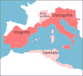
English: Map of the territories (pink) ruled by Theodoric the Great at their height in 523, when he annexed the southern part of the Burgundian kingdom, between the rivers Durance and Isere. Stippled areas indicate other kingdoms dominated by Theodoric at this time.
Datum
Zdroj prepared from information in Wikipedia, Historical Atlases, and other books,in particular The Goths by Peter Heather
Autor Howard Wiseman
Další verze based on a map at http://www.sci.gu.edu.au/~wiseman/Roman/5CompMaps.html

Licence

Vortimer na projektu Wikipedie v jazyce angličtina, držitel autorských práv k tomuto dílu, ho tímto zveřejňuje za podmínek následujících licencí:
GNU head Tento dokument smí být kopírován, šířen nebo upravován podle podmínek Svobodné licence GNU pro dokumenty verze 1.2 nebo libovolné vyšší verze publikované nadací Free Software Foundation. Dokument nemá neměnné části ani texty na předním či zadním přebalu. Kopie textu licence je k dispozici v oddíle nazvaném GNU Free Documentation License.
w:cs:Creative Commons
uveďte autora
Tento soubor podléhá licenci Creative Commons Uveďte autora 3.0 Unported
Uveďte autora: Vortimer na projektu Wikipedie v jazyce angličtina
Dílo smíte:
  • šířit – kopírovat, distribuovat a sdělovat veřejnosti
  • upravovat – pozměňovat, doplňovat, využívat celé nebo částečně v jiných dílech
Za těchto podmínek:
  • uveďte autora – Máte povinnost uvést autorství, poskytnout odkaz na licenci a uvést, pokud jste provedli změny. Toho můžete docílit jakýmkoli rozumným způsobem, avšak ne způsobem naznačujícím, že by poskytovatel licence schvaloval nebo podporoval vás nebo vaše užití díla.
Můžete si zvolit libovolnou z těchto licencí.

Původní historie souboru

Na Commons přenesl z en.wikipedia uživatel Lazyhawk pomocí nástroje CommonsHelper.

Původní stránka s popisem souboru byla zde. Všechna následující uživatelská jména odkazují na projekt en.wikipedia.
  • 2007-12-28 04:23 Vortimer 523×478× (33298 bytes) {{Information |Description=Map of the territories (pink) ruled by Theodoric the Great at their height in 523, when he annexed the souther part of the Burgundian kingdom, between the rivers Durance and Isere. Stippled areas indicate other kin
  • 2007-12-27 12:01 Vortimer 523×478× (33484 bytes) {{Information |Description=Map of the territories (pink) ruled by Theodoric the Great at their height in 523, when he annexed the souther part of the Burgundian kingdom, between the rivers Durance and Isere. Stippled areas indicate other kingdoms dominate
  • 2007-12-27 11:57 Vortimer 523×478× (32320 bytes) {{Information |Description=Map of the territories (pink) ruled by Theodoric the Great at their height in 523, when he annexed the souther part of the Burgundian kingdom, between the rivers Durance and Isere. Stippled areas indicate other kingdoms dominate

Popisky

Přidejte jednořádkové vysvětlení, co tento soubor představuje

Položky vyobrazené v tomto souboru

zobrazuje

Historie souboru

Kliknutím na datum a čas se zobrazí tehdejší verze souboru.

Datum a časNáhledRozměryUživatelKomentář
současná20. 12. 2011, 15:15Náhled verze z 20. 12. 2011, 15:15523 × 478 (33 KB)OgreBot(BOT): Reverting to most recent version before archival
20. 12. 2011, 15:15Náhled verze z 20. 12. 2011, 15:15523 × 478 (33 KB)OgreBot(BOT): Uploading old version of file from en.wikipedia; originally uploaded on 2007-12-27 12:01:51 by Vortimer
20. 12. 2011, 15:15Náhled verze z 20. 12. 2011, 15:15523 × 478 (32 KB)OgreBot(BOT): Uploading old version of file from en.wikipedia; originally uploaded on 2007-12-27 11:57:01 by Vortimer
12. 9. 2011, 03:55Náhled verze z 12. 9. 2011, 03:55523 × 478 (33 KB)File Upload Bot (Magnus Manske) {{BotMoveToCommons|en.wikipedia|year={{subst:CURRENTYEAR}}|month={{subst:CURRENTMONTHNAME}}|day={{subst:CURRENTDAY}}}} {{Information |Description={{en|Map of the territories (pink) ruled by Theodoric the Great at their height in 523, when he annexed the

Tento soubor používá následující stránka:

Globální využití souboru

Tento soubor využívají následující wiki: